Steveston in Richmond in Metro Vancouver, British Columbia — Canada’s West Coast (North America)
West Coast Fishery
⎯⎯⎯
La Pêche Sur La Côte Ouest

Photographed by Kevin Westell, July 8, 2012
1. West Coast Fishery - Marker

West Coast Fishery
For thousands of years the fishery has been vitally important to people on Canada's west coast. It provided food for Aboriginal peoples and is still an essential element of their culture. Commercial fishing began in the 1830s when the Hudson's Bay Company salted salmon for export in barrels. More efficient fishing methods, new canning and freezing technologies, and access to remote markets by ship and railway fostered an industry which has for generations employed men and women of many origins. The Gulf of Georgia Cannery, built in 1894, serves as a symbol of this history.
La Pêche Sur La Côte Ouest
Pendant des millénaires, la pêche a été vitale pour les habitants de la côte ouest. Elle assurait la subsistance des autochtones et demeure un élément essentiel de leur culture. Dans les années 1830, la Compagnie de la baie d'Hudson se mit à saler du saumon pour l'exporter en barils. L'amélioration des méthodes de pêche, la mise en conserve, la congélation et l'accès à des marchés éloignés par bateau et par train firent prospérer cette industrie, qui emploie depuis des
this page online
Erected by Historic Sites and Monuments Board of Canada.
Topics and series. This historical marker is listed in this topic list: Industry & Commerce. In addition, it is included in the Canada, Historic Sites and Monuments Board series list. A significant historical year for this entry is 1830.
Location. 49° 7.486′ N, 123° 11.191′ W. Marker is in Richmond, British Columbia, in Metro Vancouver. It is in Steveston. It is at the intersection of Fourth Avenue and Moncton Street, on the right when traveling south on Fourth Avenue. Touch for map. Marker is at or near this postal address: 12138 Fourth Avenue, Richmond BC V7E 3H1, Canada. Touch for directions.

Regionally, this marker is on the Lower Mainland and in Coast & Mountains. Globally, it is in North America, in the Cascade Range, in the Inside Passage, on the Ring of Fire, on the Pacific Rim, in the Western Hemisphere, in the Western World, and in the Anglosphere. Historically, it finds itself in what was once a British
Photographed by Kevin Westell, July 8, 2012
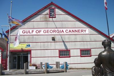
2. Gulf of Georgia Cannery
Photo faces west from Gulf of Georgia Cannery Park. The marker is on a low stand just north (right) of the entrance door.
Other nearby markers. At least 8 other markers are within 16 kilometers of this marker, measured as the crow flies: Japanese Fisherman Monument (approx. 1.1 kilometers away); Thanks and Remembrance (approx. 7.8 kilometers away); B.C. Hydro Helped The YVR Expansion Take Flight (approx. 7.8 kilometers away); Vancouver Control Tower / La tour de contrôle de Vancouver (approx. 7.8 kilometers away); New International Terminal and Third Runway (approx. 7.8 kilometers away); Whatcom County Parks & Recreation Dept (approx. 15.4 kilometers away in the U.S.); Normal School (approx. 16 kilometers away); Model School (approx. 16 kilometers away). Touch for a list and map of all markers in Richmond.
Photographed by Kevin Westell, July 8, 2012
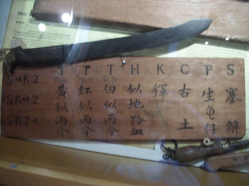
3. Directions to Fillet Various Fish Species

Photographed by Kevin Westell, July 7, 2012
4. Fish in the Fraser River
Credits. This page was last revised on September 18, 2025. It was originally submitted on September 16, 2025, by Kevin Westell of St. Catharines, Ontario. This page has been viewed 61 times since then and 18 times this year. Photos: 1, 2, 3, 4. submitted on September 16, 2025, by Kevin Westell of St. Catharines, Ontario. • Andrew Ruppenstein was the editor who published this page.
