Presidio of San Francisco in San Francisco City and County, California — The American West (Pacific Coastal)
Establishment of the Presidio of San Francisco
Photographed by Douglass Halvorsen, July 26, 2025
1. Establishment of the Presidio of San Francisco Marker
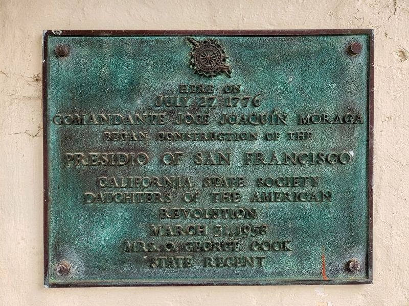
July 27, 1776
Comandante José Joaquín Moraga
Began Construction of the
Presidio of San Francisco
Erected 1958 by Daughters of the American Revolution, Mrs. O. George Cook, State Regent.
Topics and series. This historical marker is listed in these topic lists: Military • Settlements & Settlers. In addition, it is included in the Daughters of the American Revolution (DAR) series list. A significant historical date for this entry is July 27, 1776.
Location. 37° 47.865′ N, 122° 27.55′ W. Marker is in San Francisco, California, in San Francisco City and County. It is in Presidio of San Francisco. It is on Moraga Avenue, on the right when traveling east. Touch for map. Marker is at or near this postal address: 50 Moraga Avenue, San Francisco CA 94129, United States of America. Touch for directions.

Regionally, this marker is on the Coast Ranges. It is also on the American Pacific Coast. Globally, it is in North America, on the Ring of Fire, on the Pacific Rim, in the Western Hemisphere, in the Western World, and in the Anglosphere. Historically, it finds itself in what was once New Spain and also Mexico’s
this page online
Other nearby markers. At least 8 other markers are within walking distance of this marker: Oldest Adobe Building in San Francisco (within shouting distance of this marker); Site of General Pershing’s Quarters (within shouting distance of this marker); North West Corner of Original Presidio (about 300 feet away, measured in a direct line); Old Post Chapel (about 300 feet away); Outpost of an Empire (about 300 feet away); Pershing Square (about 400 feet away); Pershing Hall (about 500 feet away); Bachelor Officers' Quarters: Pershing Hall (about 500 feet away). Touch for a list and map of all markers in San Francisco.
Also see . . . 1776 - Plan of the Presidio of San Francisco.
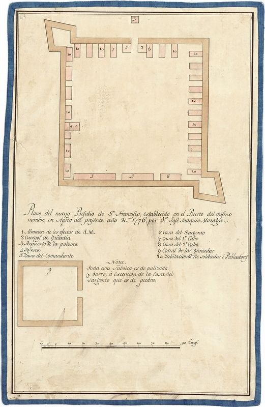
Jose Joaquin Moraga’s plan for the new San Francisco Presidio. All this construction was of palisade and mud, except for the Sergeant's house which is made of stone. This plan called for an enclosure ninety-two Varas, or two hundred and fifty-three feet, square. Structures inside the enclosure included: (1) a storage room for goods of His Majesty; (2) a guard house; (3) a magazine room for extra gun powder supply; (4)the chapel;(Submitted on September 18, 2025, by Douglass Halvorsen of Klamath Falls, Oregon.)(5) the commandant's house; (6) sergeant's house; (7) a house for the 1st Corporal; (8) a house for 2nd Corporal; (9) the cattle corral; and (10) the soldiers' and settlers' rooms. Moraga was second in command to Juan Bautista de Anza in the 1776 overland colonizing expedition from the region of Alta California which would become part of southern Arizona and northern Mexico, to what is now San Francisco, California. When de Anza returned south in 1777, Moraga was left in charge of efforts to build housing for the colonists and a military headquarters, the Presidio of San Francisco. Presidio de San Francisco became the northernmost fortress of the Spanish colonization network. The presidio's role was to protect the frontier from foreign invaders.Photographed by Douglass Halvorsen, July 26, 20252. Establishment of the Presidio of San Francisco Marker

Photographed by Douglass Halvorsen, July 26, 2025
3. Establishment of the Presidio of San Francisco
Photographed by Douglass Halvorsen, July 26, 2025
4. Establishment of the Presidio of San Francisco
Photographed by Cal State Monterey Bay Digital Commons, circa 1776
5. Establishment of the Presidio of San Francisco
1776 - Plan of the Presidio of San Francisco established at the port of the same name in August of the current year of 1776 by Don Jose Joaquin Moraga
Credits. This page was last revised on September 18, 2025. It was originally submitted on September 18, 2025, by Douglass Halvorsen of Klamath Falls, Oregon. This page has been viewed 151 times since then and 72 times this year. Photos: 1, 2, 3, 4, 5. submitted on September 18, 2025, by Douglass Halvorsen of Klamath Falls, Oregon. • Andrew Ruppenstein was the editor who published this page.
