
Garrison in McLean County, North Dakota — The American Midwest (Upper Plains)
Four Bears Bridge
Indian Hills
Photographed by Barry Swackhamer
1. Four Bears Bridge Marker
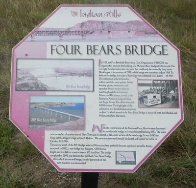
Captions:( top) 1954 Four Bears Bridge; (upper left) 1934 Four Bears Bridge; (lower left) 2003 Four Bears Bridge.
In 1928 the Fort Berthold Reservation Civic Organization (FBRCO) was organized to promote the building of a Missouri River bridge at Elbowoods. The river split the reservation into two parts that could only be crossed by ferry boats. Work began in the summer of 1932 and the bridge was completed in June 1934. To dedicate the bridge, four days of festivities were scheduled from June 15-18, 1934. The celebration included parades, rodeos, carnivals, games, Indian dancing, picnics, ceremonies and speeches. Music was provided by marching bands from Garrison, Minot, and Dickinson, as well as the Bismarck American Legion Drum and Bugle Corps. The affair attracted 8,000 visitors. The highlight of the celebration was the decmcatin ceremony on June 15, which named it the Four Bears Bridge in honor of both the Mandan and Hidatsa chiefs of that name.
With the construction of the Garrison Dam, flood waters threatened to inundate the bridge, so it was dismantled during 1953. The spans were moved to a location west of New Town and re-erected as the center section of the new bridge. It was 4,483 feet long, the longest bridge in North
this page online
The narrow width of the 1954 bridge with its 20-foot roadway gradually became a problem as traffic density increased. In 2002, a new bridge was designed, 4,200 feet in length, and was bid for construction at $55.5 million. The bridge, completed in 2005, was dedicated as the third Four Bears Bridge. after which the second bridge, located just south of the new structure, was dismantled.
Erected by Indian Hills Resort.
Topics. This historical marker is listed in this topic list: Bridges & Viaducts. A significant historical month for this entry is June 1934.
Location. 47° 35.933′ N, 102° 5.933′ W. Marker is in Garrison, North Dakota, in McLean County. It can be reached from the intersection of 73rd Avenue NorthWest and 14th Street NorthWest. The marker is located on the Nux Baa Ga (meaning “All the People” in Arikara) Trail. Touch for map. Marker is in this post office area: Garrison ND 58540, United States of America. Touch for directions.

Regionally, this marker is in North Dakota’s Mandan, Hidatsa, and Arikara Nation, in the Standing
Photographed by Barry Swackhamer
2. Four Bears Bridge Marker
Other nearby markers. At least 8 other markers are within walking distance of this marker: Encampments (about 400 feet away, measured in a direct line); Contemporary Towns (about 400 feet away); Lewis & Clark (about 600 feet away); Sakakawea (about 700 feet away); Lake Sakakawea (about 800 feet away); Geology (approx. 0.2 miles away); Nightwalker's Butte (approx. 0.2 miles away); a different marker also named Nightwalker's Butte (approx. 0.2 miles away). Touch for a list and map of all markers in Garrison.
Credits. This page was last revised on September 22, 2025. It was originally submitted on September 22, 2025, by Barry Swackhamer of Brentwood, California. This page has been viewed 58 times since then and 20 times this year. Photos: 1, 2. submitted on September 22, 2025, by Barry Swackhamer of Brentwood, California.
