
Garrison in McLean County, North Dakota — The American Midwest (Upper Plains)
Lewis & Clark
Indian Hills
Photographed by Barry Swackhamer
1. Lewis & Clark Marker
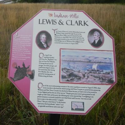
On April 9, the expedition headed west from the "Big Bend," two days out from Fort Mandan, 33 strong aboard one red pirogue, one white pirogue, and a half dozen dugout canoes. For several days after leaving Fort Mandan, they were greeted by hunting parties of Hidatsa along the banks.
One of the most embarrassing moments of the entire expedition occurred on August 11, 1806 when Lewis was shot in the buttocks while hunting with Pierre Cruzatte at a point between present-day Williston and New Town. Cruzatte was absolved of blame because, as Clark wrote in his journal, he "is near Sighted and has the use of but one eye." Despite great pain, Lewis's group pressed on and caught up with Clark and his party the following day. Lewis reported that "as wrighting in my present situation
this page online
Side-bar on left:
Lewis observed various plant and wildlife during those first days, including Jerusalem artichokes, two species of juniper, snow geese, a flicker tail, and several varieties of pocket gopher. Sgt. John Ordway noted that "The Musquetoes began to Suck our blood this afternoon." and indication of what was to come. Several months later, Lewis would describe, "Musquetoes, eye knats and prickley pears" as "our trio of pests."
Erected by Indian Hills Resort.
Topics and series. This historical marker is listed in this topic list: Exploration. In addition, it is included in the Lewis & Clark Expedition series list. A significant historical date for this entry is August 11, 1806.
Location. 47° 35.917′ N, 102° 5.8′ W. Marker is in Garrison, North Dakota, in McLean County. It can be reached from the intersection of 73rd Avenue NorthWest and 14th Street NorthWest. The marker
Photographed by Barry Swackhamer
2. Lewis & Clark Marker

Regionally, this marker is in North Dakota’s Mandan, Hidatsa, and Arikara Nation, in the Standing Rock Sioux Tribe, in the Drift Prairie, and on the Missouri Plateau. It is also in the American Lewis & Clark Corridor, on the prairies, and on the Northern Plains. Globally, it is in North America, the Western Hemisphere, the Western World, and the Anglosphere. Historically, it finds itself in what was once Rupert’s Land and also the Louisiana Purchase.
Other nearby markers. At least 8 other markers are within walking distance of this marker: Sakakawea (within shouting distance of this marker); Lake Sakakawea (within shouting distance of this marker); Contemporary Towns (about 300 feet away, measured in a direct line); Encampments (about 400 feet away); Nightwalker's Butte (about 500 feet away); a different marker also named Nightwalker's Butte (about 500 feet away); Four Bears Bridge (about 600 feet away); Geology (approx. 0.2 miles away). Touch for a list and map of all markers in Garrison.
Credits. This page was last revised on September 22, 2025. It was originally submitted on September 22, 2025, by Barry Swackhamer of Brentwood, California. This page has been viewed 56 times since then and 19 times this year. Photos: 1, 2. submitted on September 22, 2025, by Barry Swackhamer of Brentwood, California.
