Benicia in Solano County, California — The American West (Pacific Coastal)
Benicia Southern Pacific Railroad Passenger Depot
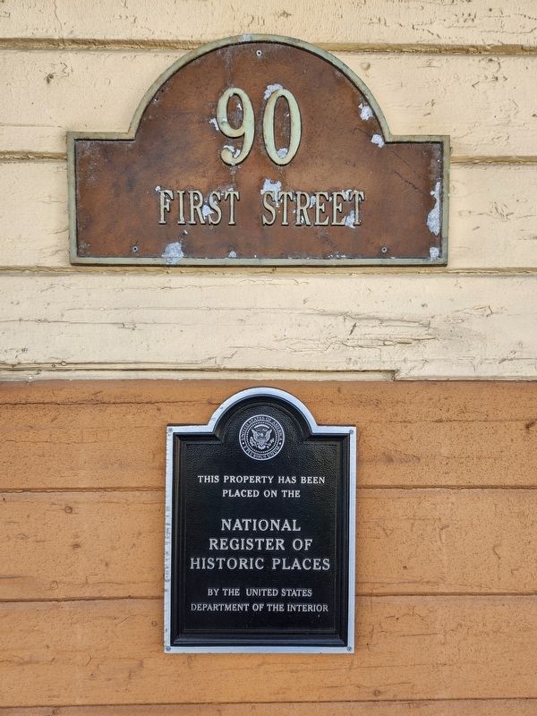
Photographed by Douglass Halvorsen, July 25, 2025
1. Southern Pacific Railroad Passenger Depot Marker
Placed on the
National
Register of
Historic Places
by the United States
Department of the Interior
Erected by United States Department of the Interior.
Topics and series. This historical marker is listed in this topic list: Railroads & Streetcars. In addition, it is included in the National Register of Historic Places (NRHP) series list.
Location. 38° 2.674′ N, 122° 9.728′ W. Marker is in Benicia, California, in Solano County. It is on First Street, on the left when traveling south. Touch for map. Marker is at or near this postal address: 90 First Street, Benicia CA 94510, United States of America. Touch for directions.

Regionally, this marker is in the San Francisco Bay Area, in the Sacramento Valley, and specifically in the Central Valley. It is also on the American Pacific Coast. Globally, it is in North America, on the Ring of Fire, on the Pacific Rim, in the Western Hemisphere, in the Western World, and in the Anglosphere. Historically, it finds itself in what was once New Spain and also Mexico’s Alta California.
Other nearby markers. At
this page online
Another marker is no longer nearby. Merritt House c. 1869 (was approx. ¼ mile away but has been confirmed missing).
Also see . . . National Register of Historic Places Registration Form (2017). Statement of Significance
The Benicia Southern Pacific Railroad Passenger Depot, constructed in Banta, California in 1897 and moved to Benicia, California in 1902, is eligible for the National Register of Historic Places under Criterion A at the local level in the area of transportation. From 1902 until 1930 the depot served as the primary passenger and freight(Submitted on October 4, 2025, by Douglass Halvorsen of Klamath Falls, Oregon.)station in Benicia, servicing a rail operation that shaped the southern waterfront and proved instrumental in facilitating local economic production. The Benicia connection was a critical link in the transcontinental railroad, navigating the Carquinez Strait using a complex train-ferry system to connect the ports of the San Francisco Bay Area to other regions of California and the United States. At the local level, the railroad operation and the connections it provided allowed Benicia to capitalize economically on its strategic geographic advantages. The rail yard reorganization and expansion, along with the installation of the new depot in 1902 cemented the railroad as a major employer and fundamental feature of the manufacturing, processing, and shipping industries located at Benicia’s waterfront during the early 20th century. The depot also qualifies for Criterion C in the area of architecture at the local level as an excellent example of the Western Stick style. Additionally, the Benicia depot is an example of the Number 18 standard depot plan used throughout California by the Southern Pacific Railroad Company in the late 19th and early 20th century.Photographed by Douglass Halvorsen, July 25, 20252. Southern Pacific Railroad Passenger Depot MarkerThe marker is visible from the street on the west side of the building.This standard style was thought to reflect a particular set of corporate values, allowed for the rapid establishment of new depots, and gave the sprawling rail enterprise a coherent regional image. The property meets the requirements of Criteria Consideration B as a moved property because it was moved to this location more than 50 years ago, establishing significance in its own right, and the more recent vertical move did not alter its orientation and brought the building up to what is now the new height of the land surrounding the property.Photographed by Douglass Halvorsen, July 25, 20253. Southern Pacific Railroad Passenger Depot


Photographed by Douglass Halvorsen, July 25, 2025
4. Southern Pacific Railroad Passenger Depot

Photographed by Douglass Halvorsen, July 25, 2025
5. Southern Pacific Railroad Passenger Depot
Credits. This page was last revised on October 4, 2025. It was originally submitted on October 4, 2025, by Douglass Halvorsen of Klamath Falls, Oregon. This page has been viewed 97 times since then and 45 times this year. Photos: 1, 2, 3, 4, 5. submitted on October 4, 2025, by Douglass Halvorsen of Klamath Falls, Oregon. • Andrew Ruppenstein was the editor who published this page.
