Sharbot Lake in Central Frontenac in Frontenac County, Ontario — Central Canada (North America)
Pump House
The Railway Heritage Walkway Tour Stop #5
Photographed by William Fischer, Jr., May 12, 2025
1. Pump House Marker
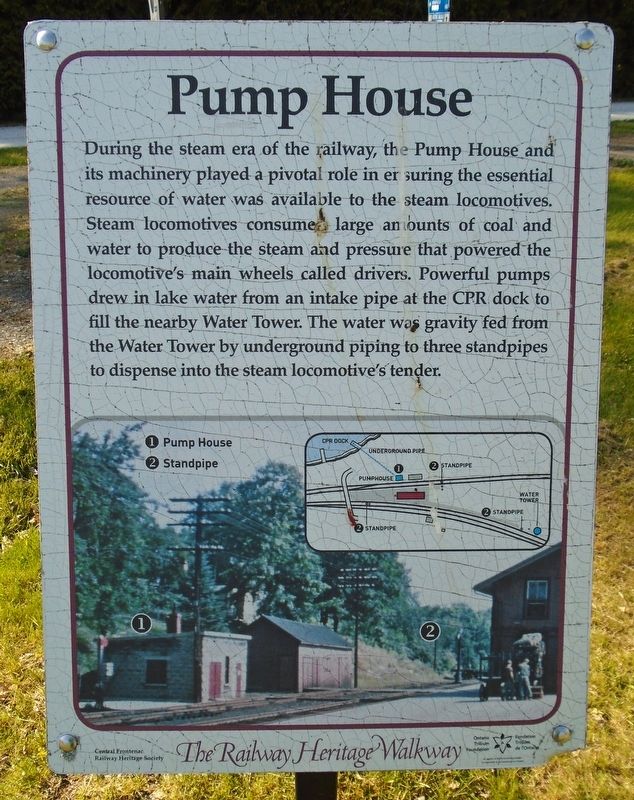
During the steam era of the railway, the Pump House and its machinery played a pivotal role in ensuring the essential resource of water was available to the steam locomotives. Steam locomotives consumed large amounts of coal and water to produce the steam and pressure that powered the locomotive's main wheels called drivers. Powerful pumps drew in lake water from an intake pipe at the CPR dock to fill the nearby Water Tower. The water was gravity fed from the Water Tower by underground piping to three standpipes to dispense into the steam locomotive's tender.
[Legend:]
① Pump House
② Standpipe
Erected 2017 by Central Frontenac Railway Heritage Society and Ontario Trillium Foundation. (Marker Number 5.)
Topics and series. This historical marker is listed in this topic list: Railroads & Streetcars. In addition, it is included in the Canada, Sharbot Lake ON Railway Heritage Walkway series list.
Location. 44° 46.394′ N, 76° 41.383′ W. Marker is in Central Frontenac, Ontario, in Frontenac County. It is in Sharbot Lake. It is at the intersection of Elizabeth
this page online

Regionally, this marker is in Eastern Ontario and specifically in Southeastern Ontario. It is also in Central Canada. Globally, it is in North America, on the Great Lakes, in the Western Hemisphere, in the Western World, and in the Anglosphere. Historically, it finds itself in what was once a British colony, the Viceroyalty of New France, the Haudenosaunee (Iroquois) Confederacy, and Rupert’s Land.
Other nearby markers. At least 8 other markers are within walking distance of this marker: Site of the Former Sharbot Lake Railway Station (a few steps from this marker); Iris versicolor (a few steps from this marker); The Station (a few steps from this marker); The Sharbot Lake Hotel (within shouting distance of this marker); The K&P (within shouting distance of this marker); The Union Hotel (within shouting distance of this marker); Section Car (within shouting distance of this marker); Track Dolly (within
Photographed by William Fischer, Jr., May 12, 2025
2. Pump House Marker
Also see . . . The Railway Heritage Walkway Tour. (Submitted on May 27, 2025, by William Fischer, Jr. of Reynoldsburg, Ohio.)
Credits. This page was last revised on October 13, 2025. It was originally submitted on May 27, 2025, by William Fischer, Jr. of Reynoldsburg, Ohio. This page has been viewed 117 times since then and 22 times this year. Last updated on October 11, 2025, by Tim Boyd of Hamilton, Ontario. Photos: 1, 2. submitted on May 27, 2025, by William Fischer, Jr. of Reynoldsburg, Ohio. • Devry Becker Jones was the editor who published this page.
