
Milford Mine Memorial Park near Wolford in Crow Wing County, Minnesota — The American Midwest (Upper Plains)
Milford Mine Pre-Disaster
Photographed by McGhiever, June 27, 2025
1. Milford Mine Pre-Disaster Marker
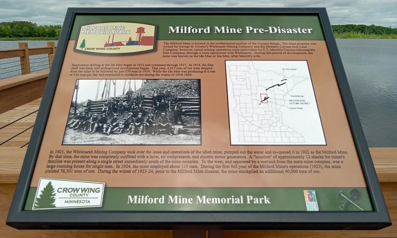
The Milford Mine is located in the northernmost portion of the Cuyuna Range. The mine property was owned by George H. Crosby's Whitmarsh Mining Company and the Messaba Cuyuna Iron Land Company; however, initial mining operations were undertaken by E.T. Merritt's Cuyuna-Minneapolis Iron Company, through a lease agreement with Whitmarsh. During this period of development, the mine was known as the Ida Mae or Ida May, after Merritt's wife.
Exploratory drilling at the Ida Mae began in 1912 and continued through 1917. In 1918, the first shaft was sunk, and underground development began. That year, 4,917 tons of ore were shipped from the mine to be followed by just 270 tons in 1919. While the Ida Mae was producing at a rate of 140 tons per day and continued to stockpile ore during the winter of 1919-1920.
In 1921, the Whitmarsh Mining Company took over the lease and operations of the idled mine, pumped out the water and re-opened it in 1922 as the Milford Mine. By that time, the mine was completely outfitted with a hoist, air compressors, and electric motor generators. A "location" of approximately 12 shacks for miner's
this page online
Erected by Crow Wing County.
Topics. This historical marker is listed in this topic list: Industry & Commerce. A significant historical year for this entry is 1912.
Location. 46° 32.123′ N, 93° 58.188′ W. Marker is near Wolford, Minnesota, in Crow Wing County. It is in Milford Mine Memorial Park. It can be reached from Milford Lake Drive. The marker is partway down the pier in Milford Lake. Touch for map. Marker is in this post office area: Crosby MN 56441, United States of America. Touch for directions.

Regionally, this marker is in Minnesota’s Northland. It is also in the American Midwest, in the Corn Belt, and in the Great River Road Region. Globally, it is in North

Photographed by McGhiever, June 27, 2025
2. Milford Mine Pre-Disaster Marker on the pier in Milford Lake
Other nearby markers. At least 8 other markers are within walking distance of this marker: Geology (within shouting distance of this marker); Timber Shaft (within shouting distance of this marker); Milford Mine Collapse (within shouting distance of this marker); a different marker also named Milford Mine Collapse (within shouting distance of this marker); a different marker also named Milford Mine Collapse (within shouting distance of this marker); Milford Miners Memorial (within shouting distance of this marker); a different marker also named Milford Mine Collapse (within shouting distance of this marker); a different marker also named Milford Miners Memorial (within shouting distance of this marker). Touch for a list and map of all markers in Wolford.
Credits. This page was last revised on October 12, 2025. It was originally submitted on October 12, 2025, by McGhiever of Minneapolis, Minnesota. This page has been viewed 59 times since then and 31 times this year. Photos: 1, 2. submitted on October 12, 2025, by McGhiever of Minneapolis, Minnesota.
