Walnut Ridge in Lawrence County, Arkansas — The American South (West South Central)
World War II Army Air Field
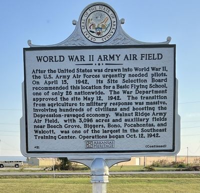
Photographed by Thomas Moore of Walnut Ridge, Arkansas
1. World War II Army Air Field Marker (Side 1)
After the United States of America was drawn into World War II, the U.S. Army Air Forces urgently needed pilots. On April 15, 1942, its Site Selection Board recommended this location for a Basic Flying School, one of only 26 nationwide. The War Department approved the site May 12, 1942. The transition from agriculture to military response was massive, involving hundreds of civilians and boosting the Depression-ravaged economy. Walnut Ridge Army Air Field, with 3,096 acres and auxiliary fields near Beech Grove, Biggers, Bono, Pocahontas, and Walcott, was one of the largest in the Southeast Training Center. Operations began Oct. 12, 1942.
In less than two years, 5,310 young men entered the nine-week program, with 4,641 cadets finishing training in the Vultee Valiant aircraft. Tragically, 42 trainees and instructors died in accidents. Classes ended June 27, 1944, and the airfield became a Marine Corps Air Facility later that year. After the war, an estimated 10,000 surplus aircraft were flown in; 4,871 were smelted, and the rest were sold. The government transferred 1,866 acres to the City of Walnut Ridge in 1950. The
this page online
Erected 2025 by Lawrence County Historical Society; Arkansas Heritage. (Marker Number 51.)
Topics and series. This historical marker is listed in these topic lists: Air & Space • War, World II. In addition, it is included in the Arkansas Heritage series list. A significant historical date for this entry is October 12, 1942.
Location. 36° 7.459′ N, 90° 55.617′ W. Marker is in Walnut Ridge, Arkansas, in Lawrence County. It is on Ramp Road, Sky Watch Road, Douglas Road. Marker stands in a field just south of the parking lot between the airport terminal (Sky Watch Road) and the Wings of Honor Museum (Ramp Road). Touch for map. Marker is at or near this postal address: 11 Sky Watch Road, Walnut Ridge AR 72476, United States of America. Touch for directions.

Regionally, this marker is in the American South and specifically in the Upper South. Globally, it is in North America, the Western Hemisphere, the Western World, and the Anglosphere. Historically, it finds itself in what was once the territory

Photographed by Thomas Moore of Walnut Ridge, Arkansas
2. World War II Army Air Field Marker (Side 2)
Other nearby markers. At least 8 other markers are within walking distance of this marker: Debra Jane "Debbie" Johnson (within shouting distance of this marker); In Honor Of Carter and Della Holm Family (within shouting distance of this marker); Duty Called…They Answered (within shouting distance of this marker); In Memory of the Young Men who made the Supreme Sacrifice (within shouting distance of this marker); To Honor Robert P Bush (within shouting distance of this marker); Company A, 2nd Battalion Memorial (approx. 0.2 miles away); T/Sgt Cucial Julian Roberts (approx. 0.2 miles away); Clark Family Served Their Country (approx. 0.2 miles away). Touch for a list and map of all markers in Walnut Ridge.
Credits. This page was last revised on February 17, 2026. It was originally submitted on October 17, 2025, by Ashley Sides of Little Rock, Arkansas. This page has been viewed 131 times since then and 52 times this year. Photos: 1, 2. submitted on October 17, 2025, by Ashley Sides of Little Rock, Arkansas. • Andrew Ruppenstein was the editor who published this page.
Editor’s want-list for this marker. A wide shot of the marker and its surroundings. • Can you help?
