Petersburg, Virginia — The American South (Mid-Atlantic)
Petersburg’s Role In Trade
Photographed by Bernard Fisher, October 16, 2011
1. Petersburg’s Role In Trade Marker
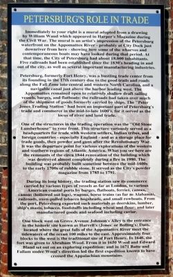
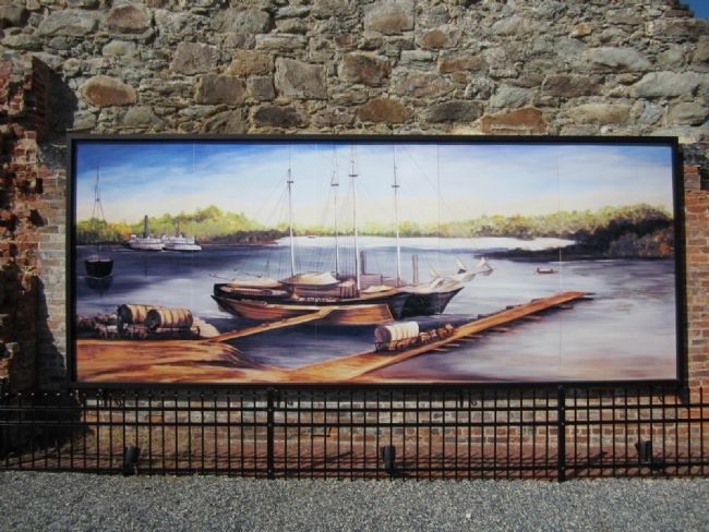
Petersburg, formerly Fort Henry, was a bustling trade center from its founding in the 17th century due to the good trails and roads along the Fall Zone into central and western North Carolina, and a navigable canal just above the harbor leading west. The Appomattox remained open to relatively shallow draft sailing vessels, barges, and flatboats: the railroads had taken over much of the shipment of goods formerly carried by ships. The “Peter Jones Trading Station” had been an important part of Petersburg’s trade and commerce in the mid-to-late 1600’s, for it served as the locus of river and land trade.
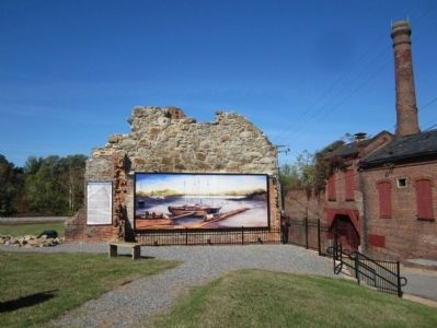
One of the structures in the trading operations was the “Old Stone Lumberhouse” to your front. This structure variously served as a headquarters for trade with western settlers, Indian tribes and foreign countries - especially England - and as a storage place for trade goods, then powder and guns after the Revolutionary War. It was the departure point for various explorations of the western and southern regions of Atlantic America. What you see here are the remnants of the circa 1844 renovation of the building which was destroyed almost completely during a fire in 1980. The building was probably built sometime between the mid-1600s to the
this page online
During its long history, the trading station saw its commerce carried by various types of vessels as far as London, to various American coastal ports by barges, flatboats, ferries, canoes, canoas (hollowed out logs), wagons, horse trains (as far as Alabama), railroads, oxen-pulled tobacco hogsheads, and small rowboats. From the port, Petersburg exported such materials as deerskins, lumber, ship’s masts, tobacco, foodstuffs including wheat and flour; and later manufactured goods and seafood including caviar.
One block west on Grove Avenue Johnson’s Alley is the entrance to the historic site known as Harvell’s (Jones’ or Bolling’s) Dam, located where the great falls of the Appomattox River meet the tidewaters of the ocean 100 miles to the east. Approximately four blocks to the west is the traditional site of Fort Henry. In 1646, the fort was given to Abraham Wood. From it in 1650 Wood and Edward Bland set out on an exploring expedition; and in 1671 Batte and Fallam under Wood’s direction led the first expedition known to have crossed the Appalachian
Photographed by Bernard Fisher, October 16, 2011
2. Peter Jones Trading Station
Erected 2011 by Petersburg Foundation, Historic Petersburg Foundation.
Topics. This historical marker is listed in these topic lists: Industry & Commerce • Settlements & Settlers. A significant historical year for this entry is 1844.
Location. Marker is missing. It was located near 37° 13.981′ N, 77° 24.443′ W. Marker was in Petersburg, Virginia. It was at the intersection of North Market Street and Grove Avenue, on the left when traveling north on North Market Street. Touch for map. Marker was in this post office area: Petersburg VA 23803, United States of America. Touch for directions.

Regionally, this marker was in Central Virginia. It was also in the American South and specifically in the Upper South. Globally, it was in North America, the Western Hemisphere, the Western World, and the Anglosphere. Historically, it found itself in what was once the territory of the Mississippian Culture, one of the original Thirteen Colonies, one of the Confederate States of America, and the Antebellum South.
Other nearby markers. At least 8 other markers are within walking distance of this location: Major Peter Jones
Photographed by Bernard Fisher, October 16, 2011
3. Mural of the Petersburg Appomattox River Waterfront
Another marker is no longer nearby. Rock Garden (was a few steps from this marker but has been confirmed missing).
Also see . . . Historic Petersburg Foundation. (Submitted on October 18, 2011.)

Photographed by Evan Dwyer, October 11, 2025
4. Petersburg’s Role In Trade Marker's Former Location
Marker has been removed.
Credits. This page was last revised on October 22, 2025. It was originally submitted on October 18, 2011, by Bernard Fisher of Richmond, Virginia. This page has been viewed 1,063 times since then and 48 times this year. Last updated on October 19, 2025, by Evan Dwyer of Richmond, Virginia. Photos: 1, 2, 3. submitted on October 18, 2011, by Bernard Fisher of Richmond, Virginia. 4. submitted on October 19, 2025, by Evan Dwyer of Richmond, Virginia.
