
Fort Calhoun in Washington County, Nebraska — The American Midwest (Upper Plains)
The Corps of Discovery

Photographed by Barry Swackhamer, July 16, 2025
1. The Corps of Discovery Marker
In 1803, President Thomas Jefferson directed his personal secretary, Meriwether Lewis, and a young army officer, William Clark, to explore the course of the Missouri River in search of a water route to the Pacific Ocean. Leading an expedition called the Corps of Discovery, Lewis and Clark were instructed to document any new plants, animals, landforms, and people they saw along the way. Accompanied by 26 men, Lewis and Clark left their camp at River Dubois in Illinois, across from St. Louis, Missouri and the mouth of the Missouri River, on May 14, 1804.
By the end of their journey, on September 23, 1806, almost 8,000 miles and 28 months later, Lewis and Clark had described 178 plants, and 122 animals previously unknown to science. Many of these species are important to today's biological arm of the federal government - the U.S. Fish and Wildlife Service. Some of the species discovered are now endangered or threatened.
July 30 - August 3, 1804
The expedition camped at the "Council Bluff" near Boyer Chute.
July 30, 1804 - Lewis begins recording natural history notes as entered in Journal Codex Q.
• A badger was preserved by Lewis, probably the first zoological specimen on the expedition.
• The first indication in the journals of the illness that your result in Sergeant Floyd's death in less than a month.
• William Clark celebrated his thirty-fourth birthday, August1, 1804.
August 3, 1804 - "The Situation of this place which we call Council Bluff which is handsome elevated a Spot well Calculated for a Trading establishment..." (William Clark)
The first expedition peace medals were distributed to Oto and Missouri leaders.
Topics and series. This historical marker is listed in this topic list: Exploration. In addition, it is included in the Lewis & Clark Expedition series
this page online
Location. 41° 27.085′ N, 95° 57.049′ W. Marker is in Fort Calhoun, Nebraska, in Washington County. It can be reached from County Road 34 near Road 51. The marker is located at Boyer Chute National Wildlife Refuge. Touch for map. Marker is in this post office area: Fort Calhoun NE 68023, United States of America. Touch for directions.

Regionally, this marker is in Eastern Nebraska and in Greater Omaha. It is also in the American Midwest, in the Lewis & Clark Corridor, in the Corn Belt, and on the prairies. Globally, it is in North America, the Western Hemisphere, the Western World, and the Anglosphere. Historically, it finds itself in what was once the Louisiana Purchase.
Other nearby markers. At least 8 other markers are within 4 miles of this marker, measured as the crow flies: Restoring River Habitat (within shouting distance of this marker); Tamed River Trade-off (within shouting distance of this marker); Fort Atkinson (approx. 3.3 miles away); The People the Expedition Met Here (approx. 3.3 miles away); Creating a Council Ceremony (approx. 3.3 miles away); Essential Friends and Allies
Photographed by Barry Swackhamer, July 16, 2025
2. The Corps of Discovery Marker, detail
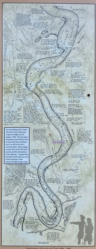
Cartographic Reconstruction Map by Martin Plamodon UTM Zone 14, 15, Map Numbers67 & 68 (Joined) Courtesy, Washington State University Press
insert: You are standing in the vicinity where the Corps of Discovery camped overnight, July 30, - August 2, 1804. The map shows the pathway of the Missouri River as Lewis and Clark would have seen it, as well as the river's current location.
Enjoy reading excerpts for Lewis and Clark's journals and their descriptions of the landscape. Compare their description with what you see at DeSoto and Boyer Chute National Wildlife Refuges today.
Click on the image to enlarge it. Unfortunately, the photograph is not sharp enough for one to read the journal entries.
insert: You are standing in the vicinity where the Corps of Discovery camped overnight, July 30, - August 2, 1804. The map shows the pathway of the Missouri River as Lewis and Clark would have seen it, as well as the river's current location.
Enjoy reading excerpts for Lewis and Clark's journals and their descriptions of the landscape. Compare their description with what you see at DeSoto and Boyer Chute National Wildlife Refuges today.
Click on the image to enlarge it. Unfortunately, the photograph is not sharp enough for one to read the journal entries.

Photographed by Barry Swackhamer, July 16, 2025
3. The Corps of Discovery Marker

Photographed by Barry Swackhamer, July 16, 2025
4. The Corps of Discovery Marker, supplementary map

Photographed by Barry Swackhamer, July 16, 2025
5. The Corps of Discovery Marker and Kiosk
Credits. This page was last revised on November 2, 2025. It was originally submitted on October 31, 2025, by Barry Swackhamer of Brentwood, California. This page has been viewed 65 times since then and 36 times this year. Photos: 1, 2, 3, 4, 5. submitted on October 31, 2025, by Barry Swackhamer of Brentwood, California.
