Brampton in Peel Region, Ontario — Central Canada (North America)
Historical Summary 27 Church Street West
⎯⎯⎯
Résumé historique 27 Church Street West
Photographed by Tim Boyd, November 2, 2025
1. Historical Summary 27 Church Street West/Résumé historique 27 Church Street West Marker

27 Church Street West
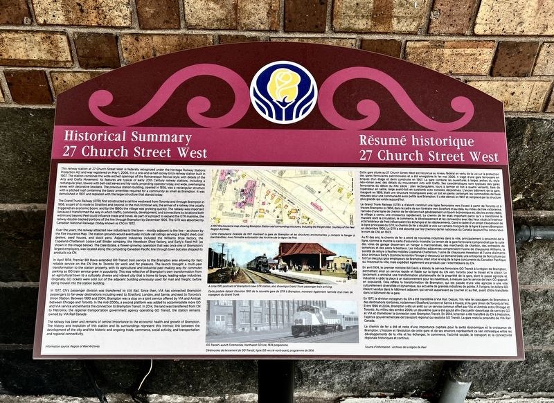
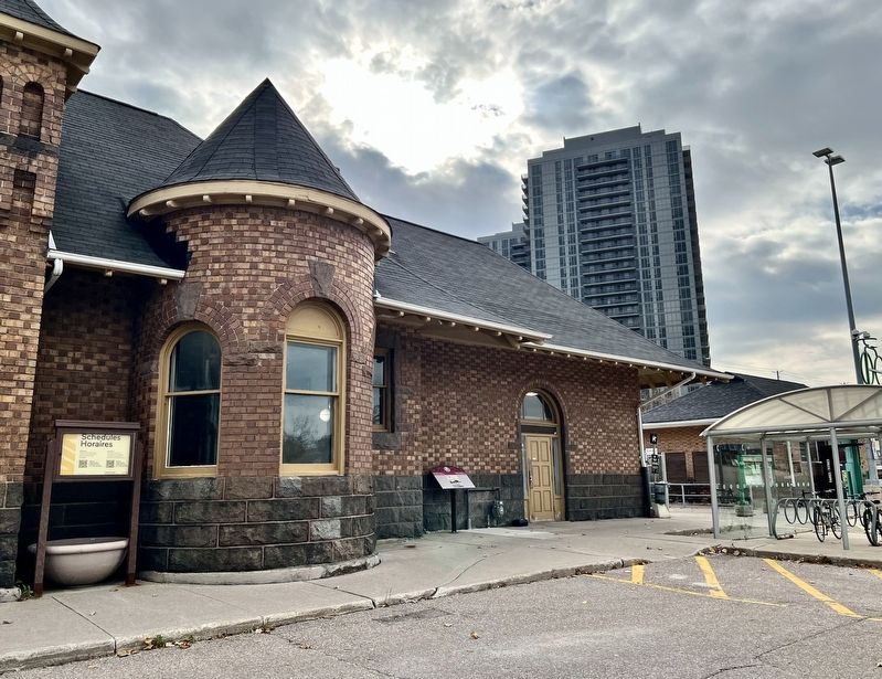
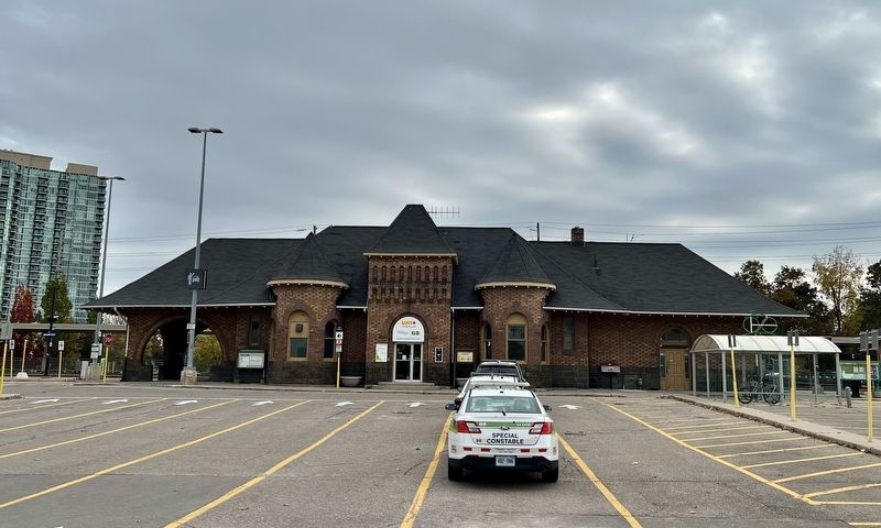
This railway station at 27 Church Street West is federally recognized under the Heritage Railway Stations Protection Act and was registered on May 1, 2006, it is a one-and-a-half-storey brick railway station built in 1907. The station combines the wide-arched openings of the Romanesque Revival style with details of the arts and Crafts Movement. Its features are typical of early 20th Century railway stations, including a rectangular plan, towers with bell-cast eaves and hip roofs, projecting operator's bay, and wide, overhanging eaves with decorative brackets. The previous station building, opened in 1856, was a rectangular structure with a pitched roof containing the basic amenities required for a community as small as Brampton. It was demolished in 1907 and replaced with the larger structure that stands today.
The Grand Trunk Railway (GTR) first constructed a rail line westward from Toronto and through Brampton in 1856, as part of its route to Stratford and beyond. In the mid-Victorian era, the arrival of a railway line usually triggered an economic boom, and by the
this page online
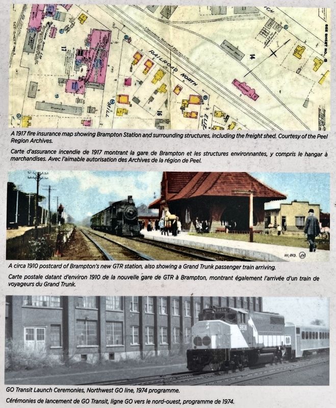
Over the years, the railway attracted new industries to the town - mostly adjacent to the line - as shown by the Fire Insurance Map. The station grounds would eventually include rail sidings serving a freight shed, coal dealers, seed houses, and stock pens. Adjacent industries included the Williams Shoe factory. the Copeland-Chatterson Loose-Leaf Binder company, the Hewetson Shoe factory, and Early's Feed Mill (as shown in the image below). The Dale Estate, a flower-growing operation that was once one of Brampton's largest employers, was located long the competing canadian Pacific line through town but aiso shipped its products via CN.
In April 1974, Premier Bill Davis extended GO Transit train service
Photographed by Tim Boyd, November 2, 2025
2. Historical Summary 27 Church Street West/Résumé historique 27 Church Street West Marker
In 1977, CN's passenger division was transferred to VIA Rail. Since then, VIA has connected Brampton passengers to far-away destinations including west to Stratford, London, and Sarnia, and east to Toronto's Union Station. Between 1990 and 2004, Brampton was a stop on a joint service offered by VIA and Amtrak between Chicago and Toronto. In the mid-200s, a second platform was added to accommodate more GO and VIA service and enhance the connection to Brampton Transit. In 2014, the land was transferred from CN to Metrolinx, the regional
Photographed by Tim Boyd, November 2, 2025
3. Historical Summary 27 Church Street West marker photos and captions detail
The railway has been and remains of central importance to the economic health and growth of Brampton The history and evolution of this station and its surroundings represent this intrinsic link between the development of the city and the historic and ongoing trade, commerce, social activity, and transportation and regional connectivity.
27 Church Street West
Cette gare située au 27 Church Street West est reconnue au niveau fédéral en vertu de la Loi sur la protection des gares ferroviaires patrimoniales et a été enregistrée le ler mai 2006. Il s'agit d'une gare ferroviaire en briques d'un étage et demi construite en 1907. La gare combine les ouvertures à larges arches du style néo-roman avec des détails du mouvement Arts and Crafts. Ses caractéristiques sont typiques des gares ferroviaires du début du XXe siècle: plan rectangulaire, tours à larmier et toit à quatre versants, baie de l'opérateur en saillie, large avant-toit en surplomb avec consoles décoratives. L'ancien bâtiment de la gare, inauguré en 1856,
Photographed by Tim Boyd, November 2, 2025
4. Brampton Via/GO Station in 2025
Le Grand Trunk Railway (GTR) a d'abord construit une ligne ferroviaire vers l'ouest à partir de Toronto et à travers Brampton en 1856, dans le cadre de son itinéraire vers Stratford et au-delà. Au milieu de l'ère victorienne, l'arrivée d'une ligne de chemin de fer déclenchait généralement un boom économique et, dès les années 1860, le village a connu une croissance rapidement. Le chemin de fer était important parce qu'il a transformé la manière dont la circulation, le commerce, le développement et les connexions avec des lieux situés à l'intérieur et à l'extérieur de Peel influençaient les échanges et les déplacements. Dans le cadre d'un projet d'expansion de la ligne principale du GTR, le chemin de fer a doublé la voie sur certains tronçons de la ligne à travers Brampton en décembre 1905. Le GTR a été absorbé par les Chemins de fer nationaux du Canada (aujourd'hui connu sous le nom de CN) en 1923.
Au fil des ans, le chemin de fer a attiré de nouvelles industries dans la ville, principalement à proximité de la ligne, comme le montre la carte d'assurance incendie. Le terrain de la gare ferroviaire comprendrait par la suite des voies de garage desservant un hangar à marchandises, des marchands de charbon, des entrepôts de semences et des parcs à bestiaux. Les industries adjacentes comprenaient l'usine de chaussures Williams, la societé de reliure à feuilles mobiles Copeland-Chatterson, l'usine de chaussures Hewetson et l'usine d'aliments pour animaux Early's (comme le montre l'image ci-dessous). Le domaine Dale, une entreprise de floriculture qui fut l'un des plus gros employeurs de Brampton, était situé le long de la ligne concurrente du Canadien Pacifique qui traversait la ville, mais expédiait également ses produits par l'intermédiaire du CN.
En avril 1974, le premier ministre Bill Davis a étendu le service ferroviaire GO Transit à la région de Brampton, permettant ainsi un service rapide et fiable sur la ligne du CN vers Toronto pour le travail et le plaisir. Le lancement a entrainé une transformation pluriannuelle de la propriété de la gare, dont le passé agricole et industriel a cédé la place à un stationnement pour les navetteurs, à mesure que le service de train GO gagnait en popularité. Cela reflète la transformation de Brampton, qui est passée d'une ville agricole à une ville culturellement diversifiée et dynamique, qui accueille de grandes industries de pointe. A l'origine, les billets GO étaient vendus dans le bâtiment adjacent qui servait auparavant au courrier et au fret, avant d'être transférés dans le bâtiment de la gare.
En 1977, la division voyageurs du CN a été transférée à VIA Rail. Depuis, VIA relie les passagers de Brampton à des destinations lointaines, notamment Stratford, London et Sarnia à l'ouest, et la gare Union de Toronto à l'est. Entre 1990 et 2004, Brampton a été un arrêt sur un service commun offert par VIA et Amtrak entre Chicago et Toronto. Au milieu des années 2000, un deuxième quai a été ajouté afin d'accueillir davantage de services GO et VIA et d'améliorer la connexion avec Brampton Transit. En 2014, le terrain a été transféré du CN à Metrolinx, l'agence gouvernementale de transport régional qui exploite GO Transit. La gare reste la propriété de VIA Rail Canada.
Le chemin de fer a été et reste d'une importance capitale pour la santé économique et la croissance de Brampton. L'histoire et l'évolution de cette gare et de ses environs représentent ce lien intrinsèque entre les développements de la ville et les échanges, le commerce, l'activité sociale, le transport et la connectivité régionale historiques et continus.
Topics. This historical marker is listed in these topic lists: Architecture • Railroads & Streetcars. A significant historical month for this entry is April 1856.
Location. 43° 41.215′ N, 79° 45.89′ W. Marker is in Brampton, Ontario, in Peel Region. It is on Church Street West 0.2 kilometers west of Main Street North, on the left when traveling west. The marker is attached to the north side of the Brampton Via/GO Station. Touch for map. Marker is at or near this postal address: 27 Church Street W, Brampton ON L6X 1G2, Canada. Touch for directions.

Regionally, this marker is in Greater Toronto, specifically on the Golden Horseshoe, and in the Toronto Metropolitan Area. It is also in Central Canada. Globally, it is in North America, on the Great Lakes, in the Western Hemisphere, in the Western World, and in the Anglosphere. Historically, it finds itself in what was once a British colony, the Viceroyalty of New France, the Haudenosaunee (Iroquois) Confederacy, and Rupert’s Land.
Other nearby markers. At least 8 other markers are within walking distance of this marker: The McKillop House (about 240 meters away, measured in a direct line); Carnegie Library (approx. half a kilometer away); St. Paul’s United Church (approx. half a kilometer away); The Old Fire Hall (approx. half a kilometer away); The Etobicoke Creek (approx. half a kilometer away); Brampton Cenotaph (approx. 0.6 kilometers away); 20th Regiment Halton Rifles/ 36th Peel Regiment (approx. 0.6 kilometers away); The Armstrong House (approx. 0.6 kilometers away). Touch for a list and map of all markers in Brampton.
Credits. This page was last revised on November 4, 2025. It was originally submitted on November 4, 2025, by Tim Boyd of Hamilton, Ontario. This page has been viewed 47 times since then and 19 times this year. Photos: 1, 2, 3, 4. submitted on November 4, 2025, by Tim Boyd of Hamilton, Ontario. • Andrew Ruppenstein was the editor who published this page.
