Burgwindheim in Bamberg, Bavaria, Germany — Central Europe
Ensemble Hauptstraße
⎯⎯⎯
Main Street Ensemble
| — | Kulturhistorischer Rundweg Burgwindheim | — |
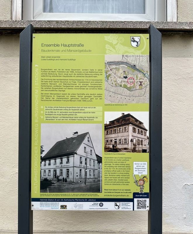
Photographed by Andrew Ruppenstein, September 2, 2025
1. Ensemble Hauptstraße / Main Street Ensemble Marker

Baudenkmale und Mansardgebäude
Burgwindheim war nie ein reines Bauerndorf, sondern hatte in seiner Funktion als Markt, Poststation (ab 1696), Amtssitz und als Wallfahrtsort eine zentrale Bedeutung. Davon zeugt auch die stattliche Bebauung entlang der wellenförmig verlaufenden Hauptstraße mit zahlreichen Baudenkmalen.
Die Errichtung des repräsentativen Amtsschlosses bis 1725 im französischen Stil hatte einen starken Bauschub zur Folge. Charakteristisch sind zahlreiche stattliche Mansard- und Walmdachhäuser mit strengen Fensterachsen, Kantenlisenen, profilierten Traufgesimsen sowie geohrten Fenstergewänden. Sie verleihen Burgwindheim auf ebenso monumentale wie vornehme Weise sein barockzeitliches Gepräge.
Bei einem Mansarddach besitzt die untere Dachhälfte eine deutlich steilere Dachneigung im Gegensatz zur oberen, flacher geneigten Dachhälfte. Der Name der charakteristisch geknickten Dachform geht auf den französischen Architekten François Mansart (1598-1666) zurück.
• Die einstige zentrale Bedeutung Burgwindheims lässt sich heute noch an den zahlreichen Baudenkmalen
this page online
• Um die Mitte des 18. Jahrhunderts muss Burgwindheim aufgrund der hohen Bautätigkeit eine einzige Baustelle gewesen sein.
• Zahlreiche Mansard- und Walmdachhäuser stehen entlang der Hauptstraße; das Mansarddach" ist nach dem franz. Architekten François Mansart benannt.
Main street ensemble
Listed buildings and mansard buildings
Burgwindheim was never a purely agricultural village, but held a central position as a market town, post station (from 1696), administrative center, and pilgrimage site. This is evidenced by the stately buildings along the undulating main street, which includes numerous listed buildings.
The construction of the impressive administrative castle in the French style, completed in 1725, triggered a significant building boom. Characteristic features include numerous stately mansard and hipped-roof houses with strict window axes, pilasters, profiled cornices, and window jambs with eared frames. These give Burgwindheim its Baroque character in a manner that is both monumental and refined.
In a mansard roof, the lower half of the roof has a significantly
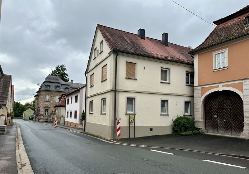
Photographed by Andrew Ruppenstein, September 2, 2025
2. Ensemble Hauptstraße / Main Street Ensemble Marker - wide view, looking east
• Burgwindheim's former central importance is still evident today in the numerous listed buildings along the main street.
• Around the mid-18th century, Burgwindheim must have been one giant construction site due to the high level of building activity.
• Numerous mansard and hipped roof houses line the main street; the mansard roof is named after the French architect François Mansart.
Erected by Markt Burgwindheim. (Marker Number 7.)
Topics. This historical marker is listed in these topic lists: Architecture • Settlements & Settlers. A significant historical year for this entry is 1725.
Location. 49° 49.629′ N, 10° 35.779′ E. Marker is in Burgwindheim, Bayern (Bavaria), in Bamberg. It is on Hauptstraße, on the right when traveling east. Touch for map. Marker is at or near this postal address: Hauptstraße 25, Burgwindheim BY 96154, Germany. Touch for directions.

Regionally, this marker is in German Franconia. Globally, it is in Europe, the European Union, Atlantic Europe, Central Europe, the Schengen Area, Western Europe, and the Western World. Historically, it finds itself in what was once the Holy Roman Empire and also the former West Germany.
Other nearby markers. At least 8 other markers are within walking distance of this marker: Kath. Pfarrkiche St. Jakobus / Catholic Parish Church of St. Jakobus (within shouting distance of this marker); Ehem. Amtschloss des Klosters Ebrach / Former Official Castle of Ebrach Monastery (within shouting distance of this marker); Ehem. Gasthof Zum Hirschen / Former Inn “Zum Hirschen” (within shouting distance of this marker); Pfarrkirche St. Jakobus / St. James Parish Church (about 90 meters away, measured in a direct line); Nonnenhof (about 120 meters away); Posthalterei / Posting Inn (about 120 meters away); Ebrachisches Richterhaus / Ebrach Magistrate’s House (about 120 meters away); Obertorbrücke / Bridge “Obertorbrücke” (approx. 0.3 kilometers away). Touch for a list and map of all markers in Burgwindheim.
Also see . . . Main street ensemble (Markt Burgwindheim). The QR code on the marker leads to this page, which is one of a set of pages, with each page describing a location on the historical tour of Burgwindheim. The text is no different than what is presented on the marker, but it does include additional photos, as well as an interactive map of the town that depicts the stops on the tour. (Submitted on November 8, 2025.)
Credits. This page was last revised on November 8, 2025. It was originally submitted on November 8, 2025, by Andrew Ruppenstein of Lamorinda, California. This page has been viewed 47 times since then and 23 times this year. Photos: 1, 2. submitted on November 8, 2025, by Andrew Ruppenstein of Lamorinda, California.
