Near Fort Calhoun in Washington County, Nebraska — The American Midwest (Upper Plains)
The Fort Storehouse
Fort Atkinson State Historical Park
Photographed by Barry Swackhamer, July 16, 2025
1. The Fort Storehouse Marker
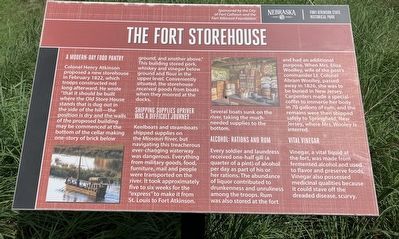
A Modern-day Food Pantry
Colonel Henry Atkinson proposed a new storehouse in February 1822, which troops constructed not long afterwards. He wrote "that it should be built where the Old Store House stands that is dug out in the side of the hill-the position is dry and the walls of the proposed building may be commenced at the bottom of the cellar making one-story of brick below ground, and another above." This building stored pork, whiskey and vinegar below ground and flour in the upper level. Conveniently situated, the storehouse goods from boats when they moored at the docks.
Shipping Supplies Upriver Was a Difficult Journey
Keelboats and steamboats shipped supplies on the Missouri River, but navigating this treacherous ever-changing waterway was dangerous. Everything from military goods, food, furniture, mail and people were transported on the river. It took approximately five to six weeks for the "express" to make it from St. Louis to Fort Atkinson. Several boats sunk on the river, taking the much-needed supplies to the bottom.
Alcohol: Rations and Rum
Every soldier and laundress received one-half gill
this page online
Vital Vinegar
Vinegar, a vital liquid at the fort, was made from fermented alcohol and used to flavor and preserve foods. Vinegar also possessed medical qualities because it could stave off the dreaded disease, scurvy.
Erected by City of Fort Calhoun, Fort Atkinson Foundation.
Topics. This historical marker is listed in these topic lists: Forts and Castles • Military. A significant historical month for this entry is February 1822.
Location. 41° 27.298′ N, 96° 0.923′ W. Marker is near Fort Calhoun, Nebraska, in Washington County. It can be reached from South 7th Street near Monroe Street. The marker is
Photographed by Barry Swackhamer, July 16, 2025
2. The Fort Storehouse Marker

Regionally, this marker is in Eastern Nebraska and in Greater Omaha. It is also in the American Midwest, in the Lewis & Clark Corridor, in the Corn Belt, and on the prairies. Globally, it is in North America, the Western Hemisphere, the Western World, and the Anglosphere. Historically, it finds itself in what was once the Louisiana Purchase.
Other nearby markers. At least 8 other markers are within walking distance of this marker: Lewis and Clark Campsite (within shouting distance of this marker); A Grinding Operation (within shouting distance of this marker); The People the Expedition Met Here (within shouting distance of this marker); Cultivating Friendship and Understanding (about 300 feet away, measured in a direct line); Creating a Council Ceremony (about 300 feet away); Essential Friends and Allies (about 300 feet away); Fort Atkinson (approx. 0.2 miles away); Fort Calhoun Schools at Washington Square (approx. 0.4 miles away). Touch for a list and map of all markers in Fort Calhoun.
Credits. This page was last revised on November 13, 2025. It was originally submitted on November 13, 2025, by Barry Swackhamer of Brentwood, California. This page has been viewed 66 times since then and 26 times this year. Photos: 1, 2. submitted on November 13, 2025, by Barry Swackhamer of Brentwood, California.
