Papillion in Sarpy County, Nebraska — The American Midwest (Upper Plains)
Papillion's History as a Main Railroad Hub
Photographed by Cosmos Mariner, September 15, 2025
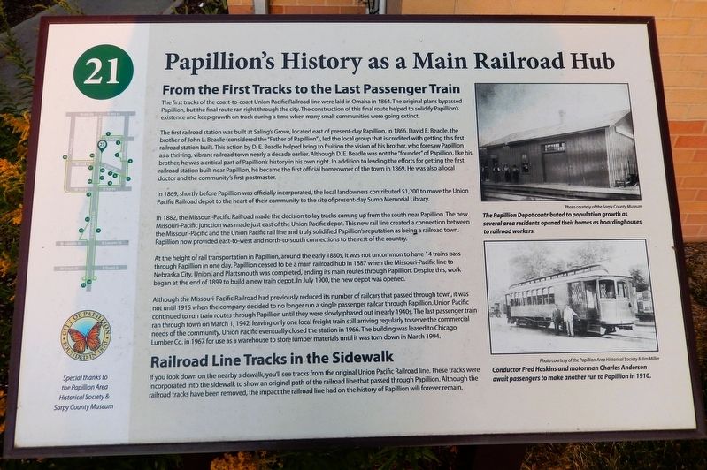
1. Papillion's History as a Main Railroad Hub Marker
From the First Tracks to the Last Passenger Train
The first tracks of the coast-to-coast Union Pacific Railroad line were laid in Omaha in 1864. The original plans bypassed Papillion, but the final route ran right through the city. The construction of this final route helped to solidify Papillion's existence and keep growth on track during a time when many small communities were going extinct.
The first railroad station was built at Saling's Grove, located east of present-day Papillion, in 1866. David E. Beadle, the brother of John L. Beadle (considered the "Father of Papillion"), led the local group that is credited with getting this first railroad station built. This action by D. E. Beadle helped bring to fruition the vision of his brother, who foresaw Papillion as a thriving, vibrant railroad town nearly a decade earlier. Although D. E. Beadle was not the "founder" of Papillion, like his brother, he was a critical part of Papillion's history in his own right. In addition to leading the efforts for getting the first railroad station built near Papillion, he became the first official homeowner of the town in 1869. He was
this page online
In 1869, shortly before Papillion was officially incorporated, the local landowners contributed $1,200 to move the Union Pacific Railroad depot to the heart of their community to the site of present-day Sump Memorial Library.
In 1882, the Missouri-Pacific Railroad made the decision to lay tracks coming up from the south near Papillion. The new Missouri-Pacific junction was made just east of the Union Pacific depot. This new rail line created a connection between the Missouri-Pacific and the Union Pacific rail line and truly solidified Papillion's reputation as being a railroad town. Papillion now provided east-to-west and north-to-south connections to the rest of the country.
At the height of rail transportation in Papillion, around the early 1880s, it was not uncommon to have 14 trains pass through Papillion in one day. Papillion ceased to be a main railroad hub in 1887 when the Missouri-Pacific line to Nebraska City, Union, and Plattsmouth was completed, ending its main routes through Papillion. Despite this, work began at the end of 1899 to build a new train depot. In July

Courtesy Sarpy County Museum
2. Marker detail: The Papillion Depot
The Papillion Depot contributed to population growth as several area residents opened their homes as boardinghouses to railroad workers.
Although the Missouri-Pacific Railroad had previously reduced its number of railcars that passed through town, it was not until 1915 when the company decided to no longer run a single passenger railcar through Papillion. Union Pacific continued to run train routes through Papillion until they were slowly phased out in early 1940s. The last passenger train ran through town on March 1, 1942, leaving only one local freight train still arriving regularly to serve the commercial needs of the community. Union Pacific eventually closed the station in 1966. The building was leased to Chicago Lumber Co. in 1967 for use as a warehouse to store lumber materials until it was torn down in March 1994.
Railroad Line Tracks in the Sidewalk
If you look down on the nearby sidewalk, you'll see tracks from the original Union Pacific Railroad line. These tracks were incorporated into the sidewalk to show an original path of the railroad line that passed through Papillion. Although the railroad tracks have been removed, the impact the railroad line had on the history of Papillion will forever remain.
Erected by Historic

Courtesy Papillion Area Historical Society & Jim Miller
3. Marker detail: Conductor Fred Haskins & Motorman Charles Anderson
Conductor Fred Haskins and Motorman Charles Anderson await passengers to make another run to Papillion in 1910.
Topics. This historical marker is listed in this topic list: Railroads & Streetcars.
Location. 41° 9.476′ N, 96° 2.567′ W. Marker is in Papillion, Nebraska, in Sarpy County. It is at the intersection of North Washington Street (Highway 85) and West 3rd Street, on the right when traveling north on North Washington Street. The marker is located beside the sidewalk at the northwest corner of the Sump Memorial Library. Touch for map. Marker is at or near this postal address: 222 North Jefferson Street, Papillion NE 68046, United States of America. Touch for directions.

Regionally, this marker is in Eastern Nebraska and in Greater Omaha. It is also in the American Midwest, in the Lewis & Clark Corridor, in the Corn Belt, and on the prairies. Globally, it is in North America, the Western Hemisphere, the Western World, and the Anglosphere. Historically, it finds itself in what was once the Louisiana Purchase.
Other nearby markers. At least 8 other markers are within walking distance of this marker: The Original Union Pacific Mainline Through Papillion

Photographed by Cosmos Mariner, September 15, 2025
4. Papillion's History as a Main Railroad Hub Marker
The marker is at the northwest corner of the Sump Memorial Library. The arrow shows where Union Pacific Railroad tracks are incorporated into the sidewalk, indicating the original path of the railroad line through Papillion.
Related markers. Click here for a list of markers that are related to this marker. Historic Downtown Papillion Walking Tour
Credits. This page was last revised on November 14, 2025. It was originally submitted on November 13, 2025, by Cosmos Mariner of Cape Canaveral, Florida. This page has been viewed 154 times since then and 123 times this year. Photos: 1, 2, 3, 4. submitted on November 14, 2025, by Cosmos Mariner of Cape Canaveral, Florida.
