
Charles City in Charles City County, Virginia — The American South (Mid-Atlantic)
Weyanoke & Parrish Hill
Charles City County, Virginia
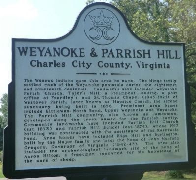
Photographed by Don Morfe, June 23, 2012
1. Wryanoke & Parrish Hill Marker
Topics and series. This historical marker is listed in these topic lists: African Americans • Notable Places. In addition,
this page online
Location. 37° 20.149′ N, 77° 3.081′ W. Marker is in Charles City, Virginia, in Charles City County. It is at the intersection of John Tyler Memorial Highway (Virginia Route 5) and Weyanoke Road ( Route 619), on the right when traveling south on John Tyler Memorial Highway. Touch for map. Marker is at or near this postal address: 12631 John Tyler Memorial Hwy, Charles City VA 23030, United States of America. Touch for directions.

Regionally, this marker is in Coastal Virginia. It is also in the American South, specifically in the Upper South, in the Tidewater, and on the Eastern Seaboard. Globally, it is in the North Atlantic Region, North America, the Western Hemisphere, the Western World, and the Anglosphere. Historically, it finds itself in what was once the territory of the Mississippian Culture, one of the original Thirteen Colonies, one of the Confederate States of America, and the Antebellum South.
Other nearby markers. At least 8 other markers are within 2 miles of this marker, measured as the crow flies: Kittiewan and Doctor Rickman (here, next to this marker); Upper Weyanoke (here, next to this marker); North Bend (a few steps from this marker); Charles City Court House (approx. 1.2 miles away); Black Political Activism in Charles City (approx. 1.2 miles away); Three Courthouse Essentials (approx. 1.2 miles away); John Tyler (approx. 1.2 miles away); America’s 3rd Oldest Courthouse (approx. 1.2 miles away). Touch for a list and map of all markers in Charles City.
Another marker is no longer nearby. New Hope & Court House (was approx. 0.7 miles away but has been confirmed missing).
Credits. This page was last revised on November 23, 2025. It was originally submitted on September 19, 2012, by Don Morfe of Baltimore, Maryland. This page has been viewed 1,683 times since then and 110 times this year. Last updated on November 23, 2025, by Evan Dwyer of Richmond, Virginia. Photo 1. submitted on September 19, 2012, by Don Morfe of Baltimore, Maryland. • Devry Becker Jones was the editor who published this page.
