Midtown - Downtown in Columbia in Richland County, South Carolina — The American South (South Atlantic)
Ordinance of Secession
( First Baptist Church )
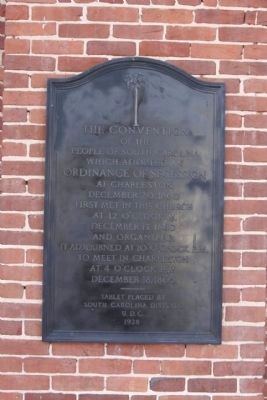
Photographed By Mike Stroud, 2010
1. Ordinance of Secession Marker
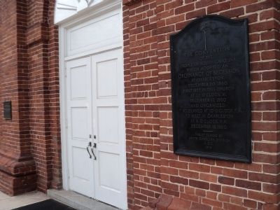
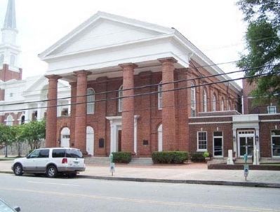
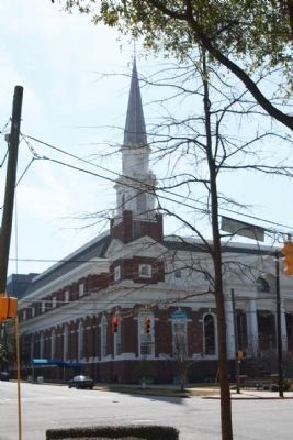
On February 17, 1865, during the Civil War, much of Columbia was destroyed by fire while being occupied by Union troops under the command of General William Tecumseh Sherman. According to legend, Columbia's First Baptist Church barely missed being torched by Sherman's troops. The soldiers marched up to the church and asked the groundskeeper if he could direct them to the church where the declaration of secession was signed. The loyal groundskeeper directed the men to the nearby Washington Street United Methodist church; thus, the historic landmark was saved from destruction by Union soldiers.
of the
people of South Carolina
which adapted an
Ordinance Of Secession
at Charleston,
December 20, 1860
first met in this church
at 12 o'clock M.[sic]
December 17, 1860
and organized.
It adjourned at 10 o' clock P.M.
to meet in Charleston
at 4 o'clock P.M.
December 18, 1860.
——
Tablet placed by
South Carolina Division
U.D.C.
1928
Topics and series. This historical marker is listed in these topic lists: Government & Politics • Notable Events • Notable Places. In addition, it is included in the National Historic Landmarks, and the United Daughters of the Confederacy series lists. A significant historical month for this entry is December 1866.
Location. 34° 0.344′ N, 81° 1.994′ W. Marker is in Columbia, South Carolina, in Richland County. It is in Midtown - Downtown. Marker is on Hampton Street, on the right when traveling east. Located between North Sumter Street and Marion Street at The First Baptist Church. Touch for map. Marker is in this post office area: Columbia SC 29201, United States of America. Touch for directions.
Other nearby markers. At least 8 other markers are within walking distance of this marker. First Baptist Church (a few steps from this marker); Site of Gibbes House (within shouting distance of this marker); Site of Columbia Female Academy (about 500 feet away, measured in a direct line); Bethel A.M.E. Church (about 500 feet away); Washington Street Methodist Church (about 500 feet away); a different marker also named Washington Street Methodist Church (about 500 feet away); Site of Columbia High School (about 500 feet away); Canal Dime Savings Bank/Bouie v. City of Columbia (1964) (about 700 feet away). Touch for a list and map of all markers in Columbia.
Regarding Ordinance of Secession. Congregation organized 1809. Original church, built 1811 on Sumter Street corner, was burned Feb. 17, 1865 by Union troops who mistook it for the present church, built 1859, where the Secession Convention had met Dec. 17, 1860. Because of reported smallpox in Columbia, the convention adjourned to Charleston.
[The Columbia Sesquicentennial Commission of 1936]
National Register of Historic Places:
First Baptist Church *** (added 1971 - - #71000800)
1306 Hampton St. , Columbia
♦ Historic Significance: Architecture/Engineering, Event
♦ Architect, builder,
or engineer: Unknown
♦ Architectural Style: Greek Revival
♦ Area of Significance: Politics/Government, Architecture
♦ Period of Significance: 1850-1874
♦ Owner: Private
♦ Historic Function: Religion
♦ Historic Sub-function: Religious Structure
♦ Current Function: Religion
♦ Current Sub-function: Religious Structure
The First Baptist Church was the scene where the first southern state convention declared its separation from the United States of America. Delegates assembled here on December 17, 1860 and unanimously declared their intent that the State of South Carolina should secede from the Union. This act of separation, coming from a state of leading political prominence, carried an immediate momentum throughout the Gulf States and Georgia, inducing them to declare their own separation. Although the convention met for only one day at Columbia and signed the State’s Ordinance of Secession only after reassembling in Charleston, the intent of the State’s political leaders was clearly and publicly declared at First Baptist. Erected in 1859, the church building features a Roman Tuscan portico and Tuscan pilasters down the sides, all rendered in molded brick. Alterations to the building occurred in 1941 and 1949. Listed in the National Register January 25, 1971; Designated a National Historic
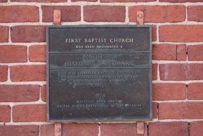
Photographed By Mike Stroud, February 21, 2010
3. at First Baptist Church
Has Been Designated A
National Historic Landmark
This Site Possesses National Significance
In Commemorating The History Of The
United States Of America
1974
National Park Service
United States Department Of The Interior
Related marker. Click here for another marker that is related to this marker. To better understand the relationship,see marker shown.
Credits. This page was last revised on February 16, 2023. It was originally submitted on March 22, 2010, by Mike Stroud of Bluffton, South Carolina. This page has been viewed 1,276 times since then and 48 times this year. Photos: 1. submitted on March 22, 2010, by Mike Stroud of Bluffton, South Carolina. 2. submitted on August 16, 2013, by Bill Coughlin of Woodland Park, New Jersey. 3, 4, 5. submitted on March 22, 2010, by Mike Stroud of Bluffton, South Carolina. • Bill Pfingsten was the editor who published this page.
