Terry Sanford in Fayetteville in Cumberland County, North Carolina — The American South (South Atlantic)
Harry F. Shaw Cross Creek Linear Park
Photographed by Devry Becker Jones (CC0), January 15, 2026
1. Harry F. Shaw Cross Creek Linear Park Marker
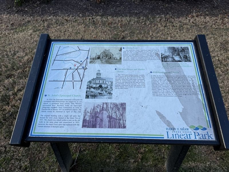
❶ Liberty Point
Just east on Bow Street, originally a wagon trail from the Cape Fear River to the settlement of Cross Creek, is Liberty Point. In 1775, a meeting of prominent citizens produced a declaration of independence from British rule. The Liberty Point Resolves preceded the Declaration of Independence by more than a year. The Liberty Point building dates to about 1791 and is the oldest commercial structure surviving in the city of Fayetteville. Nearby, west on Bow Street, stood the house where Scottish Loyalist Flora MacDonald lived.
❷ Old State House and Market House
The 1789 North Carolina General Assembly met in Fayetteville at the Old State House, which was destroyed by the Great Fire of 1831. The assembly ratified the United States Constitution, ceded its western lands to form the state of Tennessee, and chartered the first state university, the University of North Carolina. The current building, constructed in 1832 and known as the Market House, was a center of commerce well into the 20th Century.
❸ St. John's Episcopal Church
In 1816, the Episcopal community of Fayetteville
this page online
The original building with a single tall spire that housed the town clock, burned in the Great Fire of 1831. The church was rebuilt within a year on the old walls to the same plans and consecrated in 1833; however, the single clock spire was replaced with the current structure of multiple spires.
❹ First Presbyterian Church
In 1800, the Rev. John Robinson was called as a teacher and preacher by the Presbyterians in Fayetteville. Soon after his arrival from Duplin County, he began to organize a church, and on September 6, 1801, the ordinance of the Lord's Supper was administered for the first time in Fayetteville. As early as 1809, plans were made to erect a church building, Rev. Colin Melver started as a clerk of the session and was appointed to make a northern and southern excursion to solicit funds. He collected from contributors
Photographed by Devry Becker Jones (CC0), January 15, 2026
2. Harry F. Shaw Cross Creek Linear Park Marker
[Caption:]
Following a fund raising journey to the North, the First Presbyterian Church was rebuilt on the original walls and dedicated on August 12, 1832.
Topics. This historical marker is listed in these topic lists: Education • Government & Politics • Religion & Religious Structures • War, US Revolutionary. A significant historical date for this entry is September 6, 1801.
Location. 35° 3.221′ N, 78° 52.603′ W. Marker is in Fayetteville, North Carolina, in Cumberland County. It is in Terry Sanford. It is on Ann Street north of Bow Street, on the right when traveling south. Touch for map. Marker is at or near this postal address: 145 Ann St, Fayetteville NC 28301, United States of America. Touch for directions.

Regionally, this marker is in North Carolina’s Coastal Plain. It is also in the American South and specifically in the Upper South. Globally, it is in North America, the Western Hemisphere, the Western World, and the Anglosphere. Historically, it finds itself in what was once the territory of the Mississippian Culture, one of the original Thirteen Colonies, one of the Confederate States of America, and the Antebellum South.
Other nearby markers. At least 8 other markers are within walking distance of this marker: Lafayette (a few steps from this marker); Marquis de Lafayette (a few steps from this marker); Lafayette Plaza (a few steps from this marker); Beth Dail Finch (about 300 feet away, measured in a direct line); Lafayette's Tour (about 300 feet away); William Bartram Trail (about 300 feet away); Flora MacDonald (about 400 feet away); Cornwallis (about 400 feet away). Touch for a list and map of all markers in Fayetteville.
Credits. This page was last revised on January 19, 2026. It was originally submitted on January 19, 2026, by Devry Becker Jones of Washington, District of Columbia. This page has been viewed 61 times since then. Photos: 1, 2. submitted on January 19, 2026, by Devry Becker Jones of Washington, District of Columbia.
