Aiken in Aiken County, South Carolina — The American South (South Atlantic)
A View to Hamburg
Why Build a Railroad?
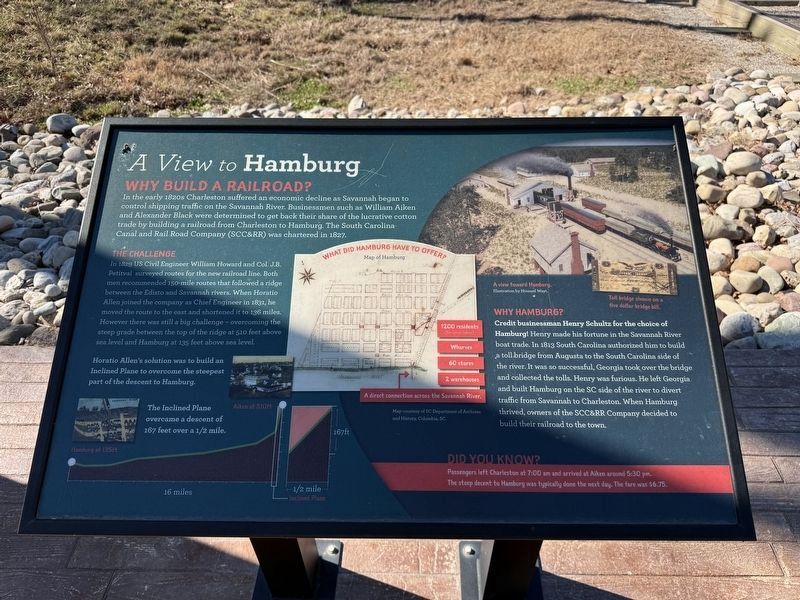
In the early 1820 Charleston suffered an economic decline as Savannah began to control shipping traffic on the Savannah River. Businessmen such as William Aiken and Alexander Black were determined to get back their share of the lucrative cotton trade by building a railroad from Charleston to Hamburg. The South Carolina Canal and Rail Road Company (SCC&RR) was chartered in 1827.
The Challenge
In 1829 US Civil Engineer William Howard and Col. J.B. Petitval surveyed routes for the new railroad line. Both men recommended 150-mile routes that followed a ridge between the Edisto and Savannah rivers. When Horatio Allen joined the company as Chief Engineer in 1831, he moved the route to the east and shortened it to 136 miles. However there was still a big challenge - overcoming the steep grade between the top of the ridge at 510 feet above sea level and Hamburg at 135 feet above sea level.
Horatio Allen's solution was to build an Inclined Plane to overcome the steepest part of the descent to Hamburg.
The Inclined Plane overcame a descent of 167 feet over a 1/2 mile.
Why Hamburg?
Credit businessman Henry Schultz for the choice of Hamburg!
this page online
Did You Know?
Passengers left Charleston at 7:00 am and arrived at Aiken around 5:30 pm. The steep decent to Hamburg was typically done the next day. The fare was $6.75.
What Did Hamburg Have to Offer?
1200 residents (for local labor) • Wharves • 60 stores • 2 warehouse • A direct connection across the Savannah River.
Erected 2022 by the City of Aiken and the Hitchcock Woods Foundation with additional support from the Aiken Land Conservancy and Aiken Streetscapes.
Topics. This historical marker is listed in these topic lists: Bridges & Viaducts • Industry & Commerce • Railroads & Streetcars • Settlements & Settlers. A significant historical year for this entry is 1820.
Location. 33° 33.366′ N,

Regionally, this marker is in Greater Augusta and in the Midlands. It is also in the American South and specifically in the Deep South. Globally, it is in North America, the Western Hemisphere, the Western World, and the Anglosphere. Historically, it finds itself in what was once the territory of the Mississippian Culture, one of the original Thirteen Colonies, one of the Confederate States of America, and the Antebellum South.
Other nearby markers. At least 8 other markers are within walking distance of this marker: Aiken and the Inclined Plane (here, next to this marker); The Trouble with Aiken's Inclined Plane (here, next to this marker); Unearthing the Inclined Plane (here, next to this marker); Powering the Inclined Plane (a few steps from this marker); Operating the Inclined Plane (a few steps from this marker); How Did it all Happen? (a few steps from this marker); A View toward Aiken (a few steps from this marker); A Railroad in the Woods (about 300 feet away, measured in a direct line). Touch for a list and map of all markers in Aiken.
Credits. This page was last revised on January 22, 2026. It was originally submitted on January 21, 2026, by Devry Becker Jones of Washington, District of Columbia. This page has been viewed 47 times since then. Photos: 1, 2. submitted on January 21, 2026, by Devry Becker Jones of Washington, District of Columbia.
