Midtown - Downtown in Columbia in Richland County, South Carolina — The American South (South Atlantic)
DuPre Building
807 Gervais Street
| — | West Gervais Street Historic District | — |
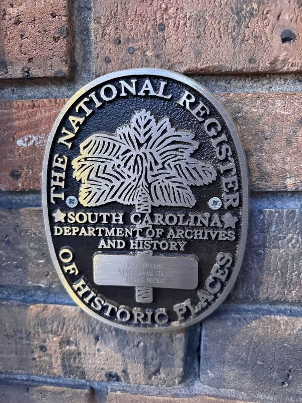
Photographed by Devry Becker Jones (CC0), January 16, 2026
1. DuPre Building marker
West Gervais Street Historic District:
National Register of Historic Places Nomination Form
Click for more information.
National Register of Historic Places Nomination Form
Click for more information.
of Historic Places
DuPre Building
West Gervais Street
Historic District
Erected by South Carolina Department of Archives and History.
Topics and series. This historical marker is listed in these topic lists: Architecture • Industry & Commerce. In addition, it is included in the South Carolina Historical Markers series list.
Location. 33° 59.975′ N, 81° 2.372′ W. Marker is in Columbia, South Carolina, in Richland County. It is in Midtown - Downtown. It is on West Gervais Street (U.S. 1/378) east of Gadsden Street, on the right when traveling west. Touch for map. Marker is at or near this postal address: 807 West Gervais Street, Columbia SC 29201, United States of America. Touch for directions.

Regionally, this marker is in the Midlands. It is also in the American South and specifically in the Deep South. Globally, it is in North America, the Western Hemisphere, the Western World, and the Anglosphere. Historically, it finds itself in what was once the territory of the Mississippian Culture, one of the original Thirteen Colonies,
this page online
Other nearby markers. At least 8 other markers are within walking distance of this marker: Lincoln Street (within shouting distance of this marker); Gadsden Street (about 300 feet away, measured in a direct line); Seaboard Air-Line Railway Station #1 (about 300 feet away); Seaboard Air-Line Railway Station #2 (about 400 feet away); Site of Wayside Hospital (about 400 feet away); 9 -11/First Responders Memorial (about 500 feet away); R.L. Bryan Co. Warehouse (about 500 feet away); Congaree Vista (about 700 feet away). Touch for a list and map of all markers in Columbia.
Regarding DuPre Building. The building is a contributing structure of the West Gervais Street Historic District.
"807 Gervais Street. A three-story brick building constructed for the DuPre Motor Company, a Ford automobile dealership, in 1919. A central recessed entry and flanking plate-glass display windows on the first floor are sheltered by a wooden awning. The second and third floors of the façade (south elevation) have seven bays, each with thirty-light metal sash. Double vertical bands of

Credits. This page was last revised on January 24, 2026. It was originally submitted on January 23, 2026, by Devry Becker Jones of Washington, District of Columbia. This page has been viewed 41 times since then. Photos: 1, 2. submitted on January 23, 2026, by Devry Becker Jones of Washington, District of Columbia.
