Midtown - Downtown in Columbia in Richland County, South Carolina — The American South (South Atlantic)
Links to the Past
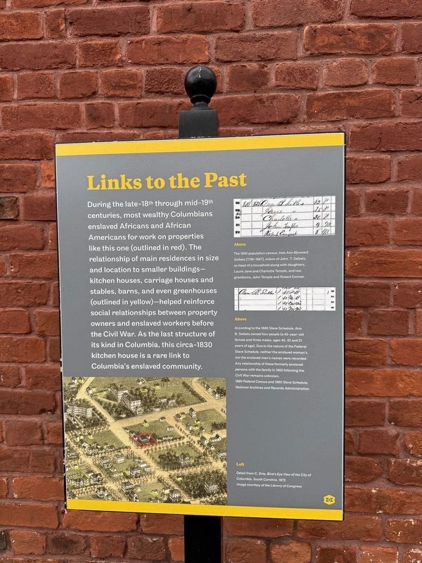
During the late-18th through mid-19th centuries, most wealthy Columbians enslaved Africans and African Americans for work on properties like this one (outlined in red). The relationship of main residences in size and location to smaller buildings—kitchen houses, carriage houses and stables, barns, and even greenhouses (outlined in yellow)—helped reinforce social relationship between property owners and enslaved workers before the Civil War. As the last structure of its kind in Columbia, this circa-1830 kitchen house is a rare link to Columbia's enslaved community.
[Captions:]
Above
The 1860 population census, lists Ann B[onner] Seibels [1796-1867], widow of John. T. Seibels, as head of a household along with daughters, Laura Jane and Charlotte Temple, and two grandsons, John Temple and Robert Emmet.
Above
According to the 1860 Slave Schedule, Ann B. Seibels owned four people (a 45-year-old female and three males, ages 40, 42 and 21) years of age). Due to the nature of the Federal Slave Schedule, neither the enslaved woman's nor the enslaved men's names were recorded. Any relationship of these formerly enslaved persons with the family in 1865 following the Civil War remains unknown.
1860 Federal Census and 1860 Slave Schedule, National Archives and Records Administration
Left
Detail from C. Drie, Bird's Eye View of the City of Columbia, South Carolina, 1872.
Image courtesy of the Library of Congress
Erected by Historic
this page online
Topics. This historical marker is listed in these topic lists: African Americans • Industry & Commerce. A significant historical year for this entry is 1860.
Location. 34° 0.781′ N, 81° 1.88′ W. Marker is in Columbia, South Carolina, in Richland County. It is in Midtown - Downtown. It is on Pickens Street north of Richland Street, on the right when traveling north. Touch for map. Marker is at or near this postal address: 1601 Pickens St, Columbia SC 29201, United States of America. Touch for directions.

Regionally, this marker is in the Midlands. It is also in the American South and specifically in the Deep South. Globally, it is in North America, the Western Hemisphere, the Western World, and the Anglosphere. Historically, it finds itself in what was once the territory of the Mississippian Culture, one of the original Thirteen Colonies, one of the Confederate States of America, and the Antebellum South.
Other nearby markers. At least 8 other markers are within walking distance of this marker: A View Worth Remembering (within shouting distance of this marker); Rooted in the Past, Enhancing the Future
Other markers no longer nearby. Pieces of the Past (was here, next to this marker but has been replaced with another marker now near it); An Enduring Landmark (was within shouting distance of this marker but has been replaced with another marker now near it).
Related marker. Click here for another marker that is related to this marker. This marker has replaced the linked marker.
Additional keywords. enslaved labor
Credits. This page was last revised on January 24, 2026. It was originally submitted on January 24, 2026, by Devry Becker Jones of Washington, District of Columbia. This page has been viewed 58 times since then. Photos: 1, 2. submitted on January 24, 2026, by Devry Becker Jones of Washington, District of Columbia.
