Lacey in Thurston County, Washington — The American West (Northwest)
From Chambers to Chalet

Photographed by Shirley A Stirling, February 10, 2026
1. From Chambers to Chalet Marker
In 1848, David and Elizabeth Harrison Chambers filed a claim for 640 acres of land on what became Chambers Prairie. Their home was located at this site, surrounded by fruit trees and livestock.
In 1917, the family sold a portion of the homestead to the Olympia Golf and Country Club; the property was later acquired by the Mountain View Golf Club. The home served as the clubhouse and then a gathering place for Panorama City residents, until it was burned down to make way for the Chalet apartment building. The Chalet was dedicated in July 1968, attended by dignitaries including Governor Dan Evans and Senator Warren Magnuson. The design by Seattle architect George Bolotin reflects a mid-century modern taste for sweeping A-frame rooflines combined with Swiss Chalet-inspired trim.
Captions
David and Elizabeth Chambers, Washington State Library Collection, Washington State Archives
Chambers Farm, 1890, painting by Edward Lange
David Chambers brought back a black Heart cherry tree from Oregon, which lived to an immense size and age, providing generations with cherry pie. See if you can spot Chambers family members perched in its limbs. Courtesy Washington State Historical Society
Mountain View Golf Club, Courtesy Lacey Museum Courtesy Washington State Historical Society
For orientation, you are standing at the site of the Chambers home. The driveway would have been at the current location of Willow Street, and the southern lobe of Chambers Lake can be seen as a sliver of blue in the distance. Chalet Dedication Panorama Resident Archives
Panel design by Amber Raney with text by Deborah Ross and Peggy Jamerson.
Erected by Panorama,
this page online
Topics. This historical marker is listed in this topic list: Settlements & Settlers. A significant historical month for this entry is July 1968.
Location. 47° 1.914′ N, 122° 49.884′ W. Marker is in Lacey, Washington, in Thurston County. It is on Circle Lane Southeast 0.1 miles east of Sleater Kinney Rd SE, on the left when traveling east. Touch for map. Marker is at or near this postal address: 1650 Circle Ln SE, Lacey WA 98503, United States of America. Touch for directions.

Regionally, this marker is in the Puget Sound Region and in Greater Seattle. It is also on the American Pacific Coast, in the Pacific Northwest, and in the Lewis & Clark Corridor. Globally, it is in North America, in the Inside Passage, on the Ring of Fire, on the Pacific Rim, in the Western Hemisphere, in the Western World, and in the Anglosphere.
Other nearby markers. At least 8 other markers are within 3 miles of this marker, measured as the crow flies: 9/11 Memorial (approx. 0.8 miles away); Gallagher House (approx. 1.2 miles away); Lacey Women's Club (approx. 1.2 miles away); Jackson Family/Goose Pond History
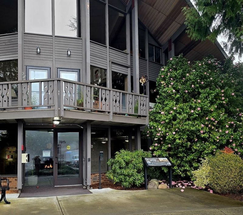
Photographed by Shirley A Stirling, February 10, 2026
2. From Chambers to Chalet Marker

Photographed by Shirley A Stirling, February 10, 2026
3. From Chambers to Chalet Marker
Credits. This page was last revised on February 15, 2026. It was originally submitted on February 10, 2026, by Shirley A Stirling of Lacey, Washington. This page has been viewed 67 times since then. Photos: 1, 2, 3. submitted on February 10, 2026, by Shirley A Stirling of Lacey, Washington. • James Hulse was the editor who published this page.
