Salida in Chaffee County, Colorado — The American Mountains (Southwest)
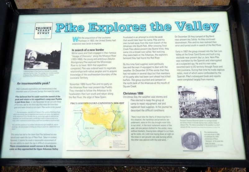
Pike Explores the Valley
| — | Collegiate Peaks Scenic and Historic Byway | — |
Photographed by Cosmos Mariner, July 23, 2025
1. Pike Explores the Valley Marker
With the acquisition of the Louisiana Purchase in 1803, the United States had extensive new lands to explore.
In search of a new border
While Lewis and Clark engaged in their famous “Voyage of Discovery” along the Missouri River (1803-1806), the young and ambitious Zebulon Montgomery Pike explored the Mississippi River to its head. With that expedition completed, Pike was ordered to negotiate relationships with native peoples and to acquire knowledge of the southwestern boundary of the Louisiana Territory.
November 1806 found Pike and his party on the Arkansas River near present day Pueblo. They intended to follow the Arkansas to its headwaters then turn south and return along the Red River, the edge of New Spain.
Frustrated in an attempt to climb the peak that would later bear his name, Pike and his men turned away from the main branch of the Arkansas into South Park. After crossing Trout Creek Pass above present day Buena Vista, they came into a broad river valley. Not realizing they were back on the Arkansas, the explorers believed they had found the Red River.
By this time food supplies were perilously low and the men ill-equipped
this page online
Christmas 1806
Christmas Day the weather was stormy and Pike elected to keep the group at camp to repair equipment, eat and replenish food supplies. In his journal he described the difficult conditions:
“Here I must take the liberty of observing that in this situation, the hardships and privations we underwent, were on this day brought more fully to our mind… in the most inclement season of the year; not one person clothed for the winter, many without blankets, (having been obliged to cut them up for socks, etc.) and now laying down at night on the snow or wet ground; one side burning whilst the other was pierced with the cold wind…”
On December 26 they camped at Big Bend near present day Salida. As they continued downstream, Pike and his men realized their error and turned south in search of the Red River.
Early in 1807 the group crossed into the San Luis Valley at the Great Sand

2. Marker detail: Pike’s Southwestern Expedition
1806-1807
1806-1807
An insurmountable peak?
Pike's Colorado explorations are memorialized in the mountain west of Colorado Springs that bears his name.
Pike believed that he could reach the summit of the peak and return to his expedition's camp near Pueblo in just three days. In late November he set out with three of his men, but by the third day they were far from their goal and were forced to turn back. Pike wrote in his journal:
“...The thermometer...here fell to 4° below 0. The summit of the Grand Peak, which was entirely bare of vegetation and covered with snow, now appeared at the distance of 15 or 16 miles from us, and as high again as what we had ascended, and would have taken a whole day's march to have arrived at its base, when I believed no human being could have ascended toThis entry has led to the claim that Pike believed no one would ever reach the top of Pikes Peak. Taken in context, however, it seems he made a reasonable assessment of his own ability to reach the top in difficult circumstances. These circumstances would worsen in the days to come as they approached the Upper Arkansas Valley.its pinical [sic].Photographed by Cosmos Mariner, July 23, 20253. Pike Explores the Valley MarkerThis marker is the rightmost of three related interpretive panels at the Christmas 1806 Picnic Ground wayside.
This with the condition of my soldiers who had only light overalls on, and no stockings...the bad prospect of killing any thing to subsist on...determined us to return.”

[photo captions]
• A photomontage of Pikes Peak from Colorado City, probably depicting Fountain Creek. The montage also includes a portrait of Zebulon Pike. Attributed to William Henry Jackson.
• President Theodore Roosevelt stands in a carriage outside the Antlers Hotel in Colorado Springs near a plaster statue of Zebulon Pike. The statue succumbed to the weather in a short amount of time.
• This commemorative coin was struck in 1906 to celebrate the 100th anniversary of Pike’s “discovery” of the peak that bears his name.
Erected by Federal Highway Administration, National Scenic Byways, and Greater Arkansas River Association.
Topics. This historical marker is listed in this topic list: Exploration. A significant historical date for this entry is December 26, 1806.
Location. 38° 35.528′ N, 106° 5.111′ W. Marker is in Salida, Colorado, in Chaffee County. It is on U.S. 285 5 miles north of U.S. 50, on the left when traveling north. The marker is located at the Christmas 1806 Picnic Ground wayside. Touch for map. Marker is at or near this postal address: 12025 US Highway 285, Salida CO, United States of America. Touch for directions.

Regionally, this marker is in the Arkansas River Valley, in the Colorado High Rockies and on the Continental Divide. It is also in the American Mountain West. Globally, it is in North America, the Rocky Mountains, the Western Hemisphere, the Western World, and the Anglosphere.
Other nearby markers. At least 8 other markers are within 5 miles of this marker, measured as the crow flies: New Faces Along the River (here, next to this marker); Finding Our Roots (here, next to this marker); Christmas 1806 (a few steps from this marker); The Faces of Industry (approx. 4.3 miles away); Remnant of an Era (approx. 4.3 miles away); A Valley Landmark (approx. 4.3 miles away); The Roof of the Rockies (approx. 4.9 miles away); Cities in the Wilderness (approx. 4.9 miles away). Touch for a list and map of all markers in Salida.
Related markers. Click here for a list of markers that are related to this marker.
Also see . . . Pike Expedition (Wikipedia).
Excerpt: The Pike Expedition (July 15, 1806 – July 1, 1807) was a military party sent out by President Thomas Jefferson and authorized by the United States government to explore the south and west of the recent Louisiana Purchase. It was led by United States Army Lieutenant Zebulon Pike, Jr. who was promoted to captain during the trip. It was the first official American effort to explore the western Great Plains and the Rocky Mountains in present-day Colorado.(Submitted on February 17, 2026, by Cosmos Mariner of Cape Canaveral, Florida.)
On November 15, Pike recorded the first sight of the distant mountain Tava which he called “Grand Peak.” It has since been called Pikes Peak in his honor. Pike tried to climb the peak’s 14,115-foot summit, hoping to get a view of the surrounding area to record on maps. Pike's group ascended a lesser summit nearby — likely Mount Rosa. With winter threatening, Pike pressed onward up the Arkansas, and on December 7 the party reached Royal Gorge, a spectacular canyon on the Arkansas at the base of the Rocky Mountains.
Credits. This page was last revised on February 17, 2026. It was originally submitted on February 15, 2026, by Cosmos Mariner of Cape Canaveral, Florida. This page has been viewed 67 times since then. Photos: 1, 2, 3. submitted on February 17, 2026, by Cosmos Mariner of Cape Canaveral, Florida.
