Harriman in Roane County, Tennessee — The American South (East South Central)
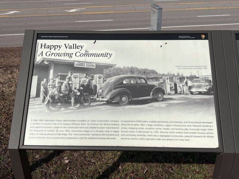
Happy Valley
A Growing Community
Photographed by Darren Jefferson Clay, February 14, 2026
1. Happy Valley Marker
An assortment of 900 trailers, multiple dormitories, army barracks, and Victory Houses developed along the turnpike. With a larger workforce, support infrastructure soon followed including a school, shopping center, recreation center, theater, and bowling alley. Eventually Happy Valley housed nearly 15,000 people by 1945. Whereas white workers had multiple housing options and community amenities, there was a segregated construction camp of hutments for African American workers which operated under ever-present Jim Crow laws.
[Caption]:
Motorists fueling up while discussing the day’s new at Happy Valley Service Station, 1940
Erected by Manhattan
this page online
Topics. This historical marker is listed in these topic lists: Industry & Commerce • War, World II. A significant historical month for this entry is May 1943.
Location. 35° 55.395′ N, 84° 23.486′ W. Marker is in Harriman, Tennessee, in Roane County. It can be reached from Tennessee 58 north of Perimeter Road, on the right when traveling north. Touch for map. Marker is at or near this postal address: 2013 TN-58, Kingston TN 37763, United States of America. Touch for directions.

Regionally, this marker is in East Tennessee and in Greater Knoxville. It is also in the American South, specifically in the Upper South, in Appalachia, and specifically in Southern Appalachia. Globally, it is in North America, the Western Hemisphere, the Western World, and the Anglosphere. Historically, it finds itself in what was once the original Cherokee Nation, the territory of the Mississippian Culture, one of the Confederate States of America, and the Antebellum South.
Other nearby markers. At least 8 other markers are within 2 miles of this marker, measured
Photographed by Darren Jefferson Clay, February 14, 2026
2. Happy Valley Marker (marker on left)
Credits. This page was last revised on February 21, 2026. It was originally submitted on February 16, 2026, by Darren Jefferson Clay of Duluth, Georgia. This page has been viewed 45 times since then. Photos: 1, 2. submitted on February 16, 2026, by Darren Jefferson Clay of Duluth, Georgia. • James Hulse was the editor who published this page.
