Dundalk in Baltimore County, Maryland — The American Northeast (Mid-Atlantic)
Proud of Our Stand
Star-Spangled Banner National Historic Trail
| — | National Park Service, U.S. Department of the Interior | — |
Photographed by F. Robby, September 8, 2013
1. Proud of Our Stand Marker
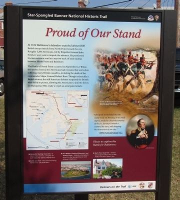
In 1814 Baltimore's defenders watched about 4,500 British troops march from North Point toward the city. Roughly 3,200 Americans, led by Brigadier General John Stricker, were sent to impede the advance. He positioned his men across a road at a narrow neck of land midway between North Point and Baltimore.
The Battle of North Point occurred on September 12. When the smoke cleared, the Americans had retreated but not before inflicting many British casualties, including the death of the Major General Robert Ross. Though technically a British victory, the stiff American defense surprised the British who failed to pursue, allowing the Americans to join the forces on Hampstead Hill, ready to repel an anticipated attack.
"I feel pride in the belief that the stand made on Monday, in no small degree, tended to check the temerity of the foe, daring to invade a country like ours, and designing the destruction of our city..." - Brigadier Gen. John Stricker (pictured here) to Major Gen. Samuel Smith, September 15, 1814.
Places to explore the Battle for Baltimore:
Methodist Meeting House Site - A church here served as a
this page online
Battle Acre Park - Monument honoring North Point "Old Defenders"
Fort McHenry National Monument and Historic Shrine - Exhibits and programs about the Star-Spangled Banner and defense of Baltimore
North Point State Park - Exhibits and programs about War of 1812; Todd's Inheritance Historic Site
[Side 2]
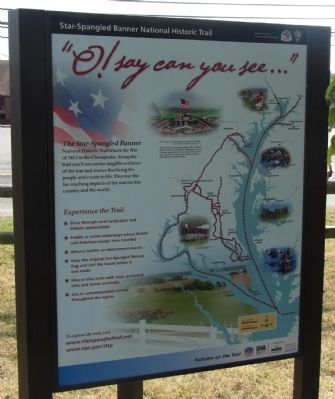
O! say can you see..."
The Star-Spangled Banner National Historic Trail traces the War of 1812 in the Chesapeake. Along the trail you'll encounter tangible evidence of the war and stories that bring the people and events to life. Discover the far-reaching impacts of the war on this county and the world.
[Side 3]
War in the Chesapeake
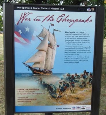
During the War of 1812 the young United States was embroiled in conflict with Great Britain. From 1812 to 1815 Americans fought to protect their rights and economic independence. They faced superior enemy forces on the homefront and the high seas.
The strategically important Chesapeake Bay region felt the brunt of the war, choked by shipping blockades and ravaged by enemy raids. The events in this region were crucial to the
Photographed by F. Robby, September 8, 2013
2. Proud of Our Stand Marker
Though there was no clear victor at the end of the war, the United States protected its democracy and emerged with heightened stature on the world stage.
Erected by National Park Service, U.S. Department of the Interior.
Topics and series. This historical marker is listed in this topic list: War of 1812. In addition, it is included in the Star-Spangled Banner National Historic Trail series list. A significant historical date for this entry is September 12, 1814.
Location. 39° 16.707′ N, 76° 29.16′ W. Marker is in Dundalk, Maryland, in Baltimore County. It is on North Point Road 0.1 miles east of Trappe Road, on the left when traveling east. Marker stands on the southeast corner of the North Point Battlefield Park. Touch for map. Marker is at or near this postal address: 8012 Kimberly Rd, Dundalk MD 21222, United States of America. Touch for directions.

Regionally, this marker is in the Baltimore Metro Region and in Central Maryland. It is also in the American Mid-Atlantic, in the Chesapeake Bay Region, and on the Eastern Seaboard. Globally, it is in the North Atlantic Region, North America, the Western Hemisphere,
Photographed by F. Robby, September 8, 2013
3. Proud of Our Stand Marker
Other nearby markers. At least 8 other markers are within walking distance of this marker: To Honor the Heroes (here, next to this marker); Hitting Home (within shouting distance of this marker); Squeeze Tactic (about 400 feet away, measured in a direct line); Home of the Brave (about 400 feet away); Battle Acre (about 400 feet away); Delay Tactic (about 400 feet away); At Patapsco Neck (about 500 feet away); Defenders Honored (about 500 feet away). Touch for a list and map of all markers in Dundalk.
Photographed by F. Robby, September 8, 2013
4. Proud of Our Stand Marker
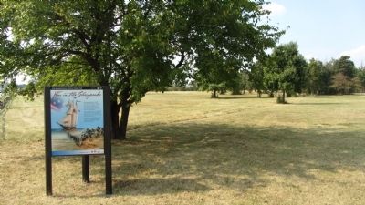
The undeveloped North Point Battlefield Park is in the background.
Credits. This page was last revised on March 9, 2026. It was originally submitted on September 9, 2013, by F. Robby of Baltimore, Maryland. This page has been viewed 1,296 times since then and 48 times this year. Last updated on March 8, 2026, by Evan Dwyer of Richmond, Virginia. Photos: 1, 2, 3, 4. submitted on September 9, 2013, by F. Robby of Baltimore, Maryland. • Devry Becker Jones was the editor who published this page.
