Block 9: 700-746 Main Street
Lots 13-24
| — | Ouray National Historic District | — |

History Colorado website entry, links to National Register of Historic Places Nomination Form
Click for more information.
Substantial brick buildings replaced wooden structures on this block by the 1890s. Louis King's two-story wagon and carriage shop dominated the south end when a wooden structure in the 1880s and as a brick beauty in the '90s. James Pierson's undertaking business, on lot 16, was Ouray's first. Both King and Pierson were talented craftsmen; King made stage coaches and carriages, Pierson created fine coffins. The artist has made every effort to accurately reproduce the structures on this block from archival photographs.
Erected 2005 by Colorado Historical Society and Ouray County Historical Society.
Topics and series. This historical marker is listed in these topic lists: Architecture • Industry & Commerce • Settlements & Settlers. In addition, it is included in the National Register of Historic Places (NRHP) series list.
Location. 38° 1.473′ N, 107° 40.279′ W. Marker is in Ouray, Colorado, in Ouray County. It is on Main Street (U.S. 550) just north of 7th Avenue, on the right when traveling north. Touch for map. Marker is at or near this postal address:
this page online

Regionally, this marker is in the Western Slope. It is also in the American Mountain West. Globally, it is in North America, the Rocky Mountains, the Western Hemisphere, the Western World, and the Anglosphere.
Other nearby markers. At least 8 other markers are within walking distance of this marker: Block 8: 800-848 Main Street (about 300 feet away, measured in a direct line); Block 18: 601-647 Main Street (about 500 feet away); True Grit Landmark #11 (about 600 feet away); The Walsh Bell (about 600 feet away); Block 11: 500-548 Main Street (approx. 0.2 miles away); Block 19: 501-545 Main Street (approx. 0.2 miles away); True Grit Landmark #10 (approx. 0.2 miles away); Beaumont (approx. 0.2 miles away). Touch for a list and map of all markers in Ouray.
Regarding Block 9: 700-746 Main Street. Contributing properties, Ouray Historic District, National Register of Historic Places № 83003537. Also, Colorado State Register of Historic Properties Site № 5OR.585.
From the National Register Nomination prepared by Martha Sullenberger and Roger Henn, 7/27/1981:
TheOuray Historic District encompasses almost the entire town which retains, to an amazing degree, its historic character spanning the period 1886 to 1915. These years encompass the height of Ouray’s importance as a supply center for nearby mining regions, and they also saw the architectural maturing of the town from a rude frame-dominated camp to a brick and stone, prosperous city. In this framework, Ouray is important as an example of the process of urbanization on the mining frontier in the last decade of the century. Along with Silverton and Telluride, Ouray was the principal town in the San Juan mining district, ranked as the third largest producing mining district in Colorado between 1893-1915 and first on the western slope. Ouray is a fine example of late 19th century architecture and a physical reminder of mining history in the San Juans.Photographed by Cosmos Mariner, July 15, 20252. Block 9: 700-746 Main Street MarkerLooking northwest across Main Street. The Faussone & Pricco building and Colombus Saloon are visible in the right background.Ouray had its beginnings as a town in 1875 when prospectors from Silverton worked their way into Ouray via Bear Creek and the Uncompahgre River searching for ore. The following spring the new community witnessed a rush and developed into a burgeoning mining camp. The town was surveyed and formally
incorporated in 1876. It had a population of 400 with 214 buildings (mostly log), a school with 43 children in attendance, four general stores, one sawmill, one ore sampling works, two hotels, and a post office. In 1877, Ouray County was established. With the removal of the Utes in 1881, the northern portion of the county was opened to ranching and homesteading. In 1882 Otto Mears constructed a toll road to the new region and Ouray was quickly taking on the trappings of a true urban center. Brick buildings began to replace the less permanent, more hazardous frame ones. By 1885, the town had a population of 1800. The silver crash of 1893 proved a temporary disaster to Ouray, as for the entire San Juan region which had primarily been a silver mining area. After a brief depression Ouray continued to grow and thrive because of rich gold mines which had been developed on Gold Hill, just north of Ouray. Ouray reached its peak around the turn-of-the-century. By 1900 it had a population of 2,196. Many large, predominantly Queen Anne style homes were built, concentrated in the southeast section of town. The commercial district contained manyPhotographed by Cosmos Mariner, July 15, 20253. Block 9: 700-746 Main Street MarkerLooking southwest across Main Street. The Story Block is across Main Street to the left - obscured here by flowers hanging on the light pole.brick structures ornately finished with cast iron facades or Italianate or Romanesque brickwork.Photographed by Cosmos Mariner, July 15, 20254. Faussone & Pricco Building (left) — built in 1906From the National Register Nomination:
Italianate, one-story rectangular brick structure. It has a central doorway with two-light transoms and is flanked by four large display windows, each with two-light transoms. Two windows are angled and two are flush with the facade. It has a cast-iron bracketed cornice with sign space reading “Faussone and Pricco.” Below the cornice “The Cascade Grocery Co.” has been painted onto the brick facade [only ghost of painted sign remains in 2025].It is typical of the small brick businesses which appeared in Ouray about 1900. Its original owners and builders were Italian, but a change in the partnership with a non-Italian resulted in the grocery becoming the largest mine supplying grocery in town. Descendants of the original Pricco that built the building still own it and plan to operate a deli beginning in the summer of 1983.


Also see . . . Ouray Historic District (Wikipedia).
Excerpt: The Ouray Historic District, in Ouray, Colorado, is a 114-acre historic district which was listed on the National Register of Historic Places in 1983. Many of the commercial buildings are Italianate in style; many residences are Victorian. Its 270 contributing buildings include government and commercial buildings. Many of the commercial buildings are along Ouray's Main Street, also known as Main Street, which is U.S. Highway 550. The historic district encompasses almost all the original townsite.(Submitted on March 12, 2026, by Cosmos Mariner of Cape Canaveral, Florida.)

Two-story brick corner business block. Doorway is set at the corner and angled. The door is two-panel wood with flush, blind transoms. The door is flanked by one and then three flush windows with fixed transoms. The door is flanked by stone pilasters with cast-iron pilasters separating the windows. A cast-iron cornice divides the first and second story. Second story windows are double-hung with stone lintels and lugsills. Brickwork is visible below a cast-iron bracketed cornice.
This building operated as the Columbus saloon from its construction in the late 1890s. The second floor was a gambling house. It is one of the few remaining brick corner blocks in Ouray.
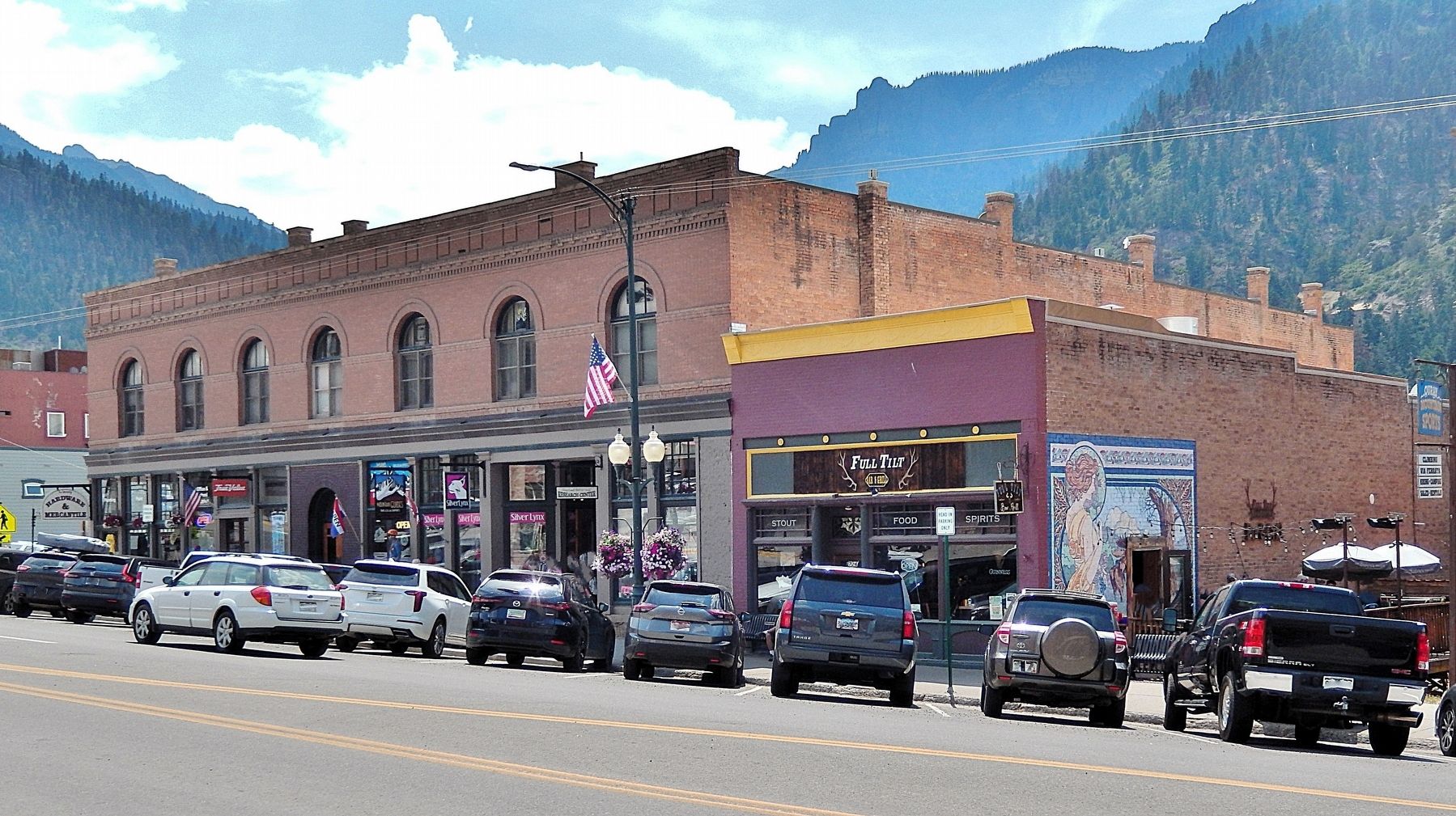
Large, two-story, prominent brick business block on the northwest corner of Main Street and Seventh Avenue, encompassing three business fronts. The fronts are typical with a central doorway flanked by large display windows. The second story windows are sash windows, with arched transoms and Romanesque round arch surrounds. The cornice is decorated with panel brickwork.
Previous to its construction a livery barn and wagon and carriage building shop was operated on the site by Louis King on the ground floor off Seventh Avenue; a paint shop was on the Main Street level. This building burned in 1892 and King constructed the present structure that same year. On the Main Street level were located a corner saloon, shops and offices. On the ground level from Seventh Avenue, King continued to operate his carriage shop and on the second floor was a boarding house, according to Sanborn maps.
Business reversals led to a mortgage default and the property passed into the hands of Judge William Story, one of the founders of Utah Power and Light Company. Story replaced the King name on the buildings with a brass plate carrying his name. The second floor was changed to the Hotel Wilson, a most respectable hotel that operated until very recent years before that floor was converted to offices, apartments and a music hall. On the Main Street level, the Sanborn 1908 map shows a saloon (the Bank Saloon) on the corner and a clothing store occupying most of the remaining building. After prohibition, Massard and Schneider operated the Post Office Drug Store where the saloon had been, and the post office occupied the space in the rear that had once been a restaurant. They also operated one of Ouray’s earliest movie houses in a part of the building.
Credits. This page was last revised on September 15, 2026. It was originally submitted on March 10, 2026, by Cosmos Mariner of Cape Canaveral, Florida. This page has been viewed 15 times since then. Photos: 1, 2, 3, 4, 5, 6. submitted on March 12, 2026, by Cosmos Mariner of Cape Canaveral, Florida.
