Ashaway in Hopkinton in Washington County, Rhode Island — The American Northeast (New England)
7th Day Baptist Churches of Hopkinton and Westerly
Inscription.
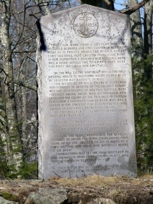
Here for more than a century was the religious, business and civil center of Westerly. Near by in private homes, the people met in town meetings. Here crossed paths from what is now Hopkinton, Richmond and Westerly. Here were the first mill dam and grist mill.
On the hill to the northeast stood the first meeting house in Southern Rhode Island built by Seventh-day Baptists in 1680.
The members of this church suffered imprisonment in defense of the colony's domain, met the onslaughts of hostile natives, were foremost among these who established and developed the colony on the principles of freedom, furnished a Governor, Samuel Ward, who was leader in the struggle for independence and joined in founding Brown University.
In the river pool near by more than 3000 were baptized.
The first road was laid out in 1702, it led to the South Kingstown town line and to the town landing at Pawcatuck Rock.
In 1736 the people petitioned the General Assembly to divide the town, complaining that "some of us are obliged to go 10 miles to a town meeting and great and difficult rivers to go over."
Charlestown was set off from Westerly in 1738, Richmond from Charlestown in 1747, and Hopkinton from Westerly in 1757.
Erected by Seventh-Day Baptist Churches of Hopkinton and Westerly.
Topics. This historical marker is listed in these topic lists: Churches & Religion • Colonial Era • Settlements & Settlers. A significant historical year for this entry is 1680.
Location. 41° 23.989′ N, 71° 47.982′ W. Marker is in Hopkinton, Rhode Island, in Washington County. It is in Ashaway. Marker is at the intersection of Nooseneck Hill Road (U.S. 3) and Chase Hill Road, on the right when traveling south on Nooseneck Hill Road. On north side of Meeting House Bridge (over the Pawcatuck River) at town lines of Westerly and Hopkinton, Rhode Island. Touch for map. Marker is in this post office area: Ashaway RI 02804, United States of America. Touch for directions.
Other nearby markers. At least 8 other markers are within 2 miles of this marker, measured as the crow flies. Seventh Day Baptist Minister's Monument (about 600 feet away, measured in a direct line); First Seventh Day Baptist Church of Hopkinton (approx. 1.4 miles away); George Kent Performance Hall (approx. 1.8 miles away); Westerly Telephone Co. (approx. 1.8 miles away); Westerly Armory (approx. 1.9 miles away); Warren Manning (approx. 2 miles away); Frank Hamilton (approx. 2 miles away); Korean War (approx. 2.1 miles away). Touch for a list and map of all markers in Hopkinton.
Credits. This page was last revised on June 26, 2023. It was originally submitted on April 9, 2010, by Dwight C. Brown Jr. of Bradford, Rhode Island. This page has been viewed 2,228 times since then and 71 times this year. Photo 1. submitted on April 9, 2010, by Dwight C. Brown Jr. of Bradford, Rhode Island. • Bill Pfingsten was the editor who published this page.
