Cambria in San Luis Obispo County, California — The American West (Pacific Coastal)
Restoration of Land and Culture
Photographed by Jason Voigt, March 25, 2026
1. Restoration of Land and Culture Marker
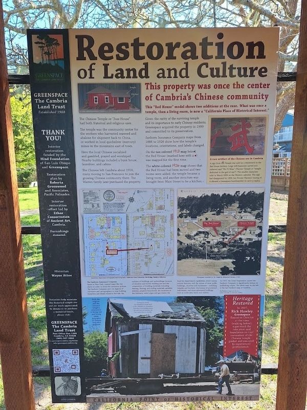
This property was once the center of Cambria's Chinese community
This "Red House" model shows two additions at the rear. What was once a temple, then a living room, is now a "California Place of Historical Interest."
The Chinese Temple or "Joss House" had both fraternal and religious uses.
The temple was the community center for the workers who harvested seaweed and abalone for shipment back to China, or worked in local quicksilver (mercury) mines in the mountains east of town.
Here the local Chinese socialized and gambled, prayed and worshiped. Nearby buildings included a bunk house, laundries, and cabins.
The Chinese left Cambria about 1916, many moving to San Francisco to join the growing Chinese community there. The Warren family later purchased the property.
Given the rarity of the surviving temple and its importance to early Chinese residents, Greenspace acquired the property in 1999 and committed to its preservation.
Sanborn Insurance Company maps from 1886 to 1926 show how the temple's locations, orientations, and labels changed.
On the tan-colored 1913 map below, the Red House was mapped
this page online
The white-colored 1926 map shows that the Red House had been moved and two rooms were added: the temple became a living room, and another structure was brought from Main Street to be a kitchen.
The Sanborn Insurance Company, based in New York, created maps like the above in order to write fire insurance policies. The Sanborn Company sent out legions of surveyors and cartographers to map building footprints and details related to fire risk: the outlines of buildings and outbuildings; location of windows and doors; building use and the composition of building materials including framing, flooring, and roofing materials; sprinkler systems; property boundaries; the locations of fire hydrants, water pipes and gas mains; the local fire department's capabilities; street names; natural features; and the names of most public buildings, churches and businesses - including temples and brothels, the homes of prominent individuals, and more ephemeral buildings such as outhouses, barns and stables.
In 1929, the Great Depression caused the Sanborn Company to significantly reduce its publishing output. The white map on the
Photographed by Jason Voigt, March 25, 2026
2. Restoration of Land and Culture Marker
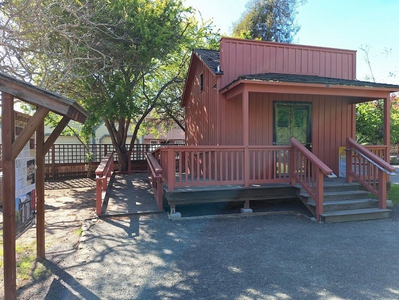
Marker is next to the restore Chinese Temple.
Heritage Restored
In 2007, Rick Hawley, Greenspace Executive Director at the time, supervised the relocation and foundation-to-roof restoration of the Chinese temple, guided and executed by experienced professionals.
(aside:)
A rare artifact of the Chinese era in Cambria
A sign from the Temple was used as a drainboard in the Red House kitchen. Large red characters carved into redwood said "Wu Ti Miao" (Warrior Temple or "temple dedicated to the god of war"). The smaller characters refer to March 1899 on the Western calendar. The sign had disappeared by 1999, but Forrest Warren's tracing of it allowed a Greenspace boardmember to carve a replica.
Erected by Greenspace Cambria.
Topics. This historical marker is listed in these topic lists: Asian Americans • Industry & Commerce • Religion & Religious Structures. A significant historical month for this entry is March 1899.
Location. 35° 33.786′ N, 121° 4.889′ W. Marker is in Cambria, California, in San Luis Obispo County. It can be reached from the intersection of Center Street and Hesparian Lane. Touch for map. Marker is at or near this postal address: 2276 Center St, Cambria CA 93428, United States of America. Touch for directions.

Regionally, this marker is on the Central Coast and specifically on the Coast Ranges. It is also on the American Pacific Coast. Globally, it is in North America, on the Ring of Fire, on the Pacific Rim, in the Western Hemisphere, in the Western World, and in the Anglosphere. Historically, it finds itself in what was once New Spain and also Mexico’s Alta California.
Other nearby markers. At least 8 other markers are within walking distance of this marker: Restored Chinese Temple (a few steps from this marker); California Native Plant Garden (within shouting distance of this marker); Greenspace Creekside Reserve (within shouting distance of this marker); Santa Rosa Creek (within shouting distance of this marker); The Guthrie-Bianchini House (within shouting distance of this marker); Cambria Veterans' Memorial (approx. 0.8 miles away); Piedras Blancas Lighthouse Lens (approx. 0.9 miles away); Nitt Witt Ridge (approx. one mile away). Touch for a list and map of all markers in Cambria.
Another marker is no longer nearby. Preserving a Bit of History (was within shouting distance of this marker but has been permanently removed).
Also see . . . Greenspace Cambria. This is a non-profit land conservation trust since 1988. (Submitted on April 23, 2026, by Jason Voigt of Glen Carbon, Illinois.)
Credits. This page was last revised on April 23, 2026. It was originally submitted on April 23, 2026, by Jason Voigt of Glen Carbon, Illinois. This page has been viewed 26 times since then. Photos: 1, 2. submitted on April 23, 2026, by Jason Voigt of Glen Carbon, Illinois.
