Princeton Junction in West Windsor Township in Mercer County, New Jersey — The American Northeast (Mid-Atlantic)
Berrien City Historic Neighborhood
Historical Society of West Windsor, May 2, 2026
1. Berrien City Historic Neighborhood Marker
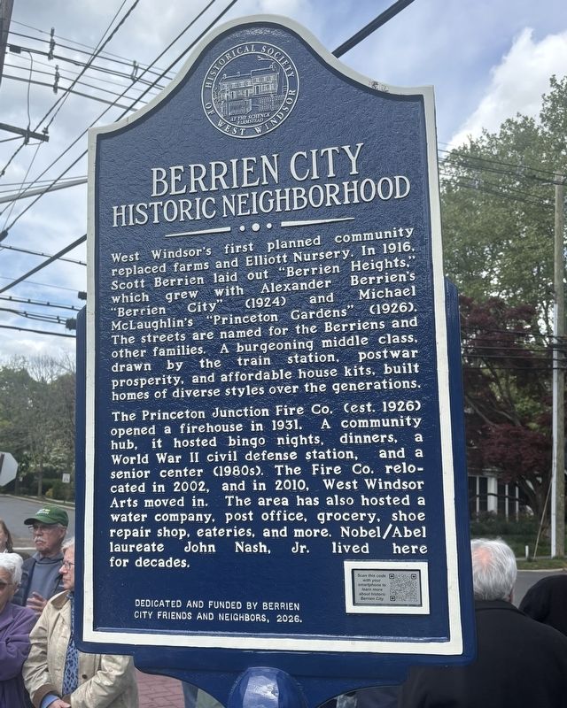
West Windsor's first planned community replaced farms and Elliott Nursery. In 1916, Scott Berrien laid out "Berrien Heights," which grew with Alexander Berrien's "Berrien City" (1924) and Michael McLaughlin's "Princeton Gardens" (1926). The streets are named for the Berriens and other families. A burgeoning middle class, drawn by the train station, postwar prosperity, and affordable house kits, built homes of diverse styles over the generations.
The Princeton Junction Fire Co. (est. 1926) opened a firehouse in 1931. A community hub, it hosted bingo nights, dinners, a World War II civil defense station, and a senior center (1980s). The Fire Co. relocated in 2002, and in 2010, West Windsor Arts moved in. The area has also hosted a water company, post office, grocery, shoe repair shop, eateries, and more. Nobel/Abel laureate John Nash, Jr. lived here for decades.
City Friends and Neighbors, 2026.
Erected 2026 by Historical Society of West Windsor.
Topics. This historical marker is listed in this topic list: Settlements & Settlers. A significant historical year for this entry is 1916.
Location. 40° 18.753′ N,
this page online

Regionally, this marker is in Central Jersey and in Greater Princeton. It is also in the American Northeast and in the Mid-Atlantic. Globally, it is in North America, the Western Hemisphere, the Western World, and the Anglosphere. Historically, it finds itself in what was once New Netherland and also one of the original Thirteen Colonies.
Other nearby markers. At least 8 other markers are within 2 miles of this marker, measured as the crow flies: John & Alicia Nash (approx. 0.2 miles away); West Windsor Township Liberty Tree (approx. half a mile away); Grovers Mill Historic Community (approx. 0.9 miles away); Raggedy Ann & Andy Farm (approx. 0.9 miles away); Martian Landing Site (approx. one mile away); Trolley Line Trail Memorial
Historical Society of West Windsor, May 2, 2026
2. Berrien City Historic Neighborhood Marker
Also see . . . Berrien City - Historical Society of West Windsor. (Submitted on May 8, 2026, by Historical Society of West Windsor of West Widsor, New Jersey.)
Credits. This page was last revised on May 8, 2026. It was originally submitted on May 3, 2026, by Historical Society of West Windsor of West Widsor, New Jersey. This page has been viewed 19 times since then. Photos: 1. submitted on May 3, 2026, by Historical Society of West Windsor of West Widsor, New Jersey. 2. submitted on May 4, 2026, by Historical Society of West Windsor of West Widsor, New Jersey. • Michael Herrick was the editor who published this page.
