Etowah in McMinn County, Tennessee — The American South (East South Central)
Historic Etowah
Photographed by Tom Bosse, May 9, 2026
1. Historic Etowah Marker
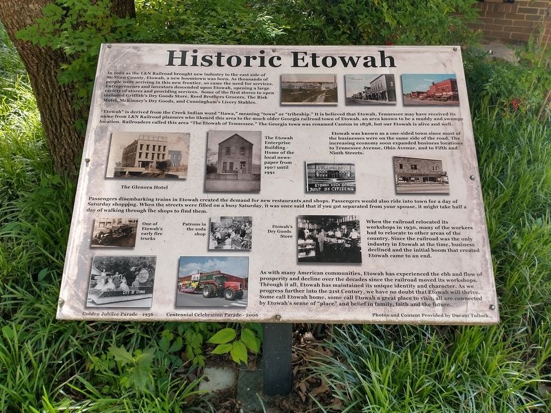
In 1902 as the L&N Railroad brought new industry to the east side of McMinn County, Etowah, a new boomtown was born. As thousands of people were arriving in this new frontier, so came the need for services. Entrepreneurs and investors descended upon Etowah, opening a large variety of stores and providing services. Some of the first stores to open included Griffith’s Dry Goods Store, Reed Brothers Grocers, The Risk Motel, McKinney’s Dry Goods, and Cunningham’s Livery Stables.
“Etowah” is derived from the Creek Indian word “Itawa”, meaning “town” or “tribeship”. It is believed that Etowah, Tennessee may have received its name from L&N Railroad planners who likened this area to the much older George railroad town of Etowah, an area known to be a muddy and swampy location. Railroaders called this area “The Etowah of Tennessee”. The Georgia town was renamed Canton in 1838, but our Etowah is alive and well.
Etowah was known as a one-sided town since most of the businesses were on the same side of the road. The increasing economy soon expanded business locations to Tennessee Avenue, Ohio Avenue, and to Fifth and Ninth Streets.
this page online
Passengers disembarking trains in Etowah created the demand for new restaurants and shops. Passengers would also ride into town for a day of Saturday shopping. When the streets were filled on a busy Saturday, it was once said that if you got separated from your spouse, it might take half a day of walking through the shops to find them.
When the railroad relocated its workshops in 1930, many of the workers had to relocate to other areas of the country. Since the railroad was the only industry in Etowah at the time, business declined and the initial boom that created Etowah came to an end.
As with many American communities, Etowah has experienced the ebb and flow of prosperity and decline over the decades since the railroad moved its workshops. Through it all, Etowah has maintained its unique identity and character. As we progress further in the 21st Century, we have no doubt that Etowah will thrive. Some call Etowah home, some call Etowah a great place to visit, all are connected by Etowah’s sense of “place” and belief in family, faith, and the future.
[Captions]:
The Glenora Hotel
The Etowah Enterprise Building – Home of the local newspaper from 1907 until 1991
One of Etowah’s early fire trucks
Patrons in the soda shop
Etowah’s Dry Goods Store
Golden Jubilee Parade – 1957
Centennial Celebration Parade – 2006
Photos and Content Provided by Durant Tullock
Topics.

Photographed by Tom Bosse, May 9, 2026
2. Historic Etowah Marker
Location. 35° 19.34′ N, 84° 31.584′ W. Marker is in Etowah, Tennessee, in McMinn County. It is at the intersection of 9th Street and U.S. 411, on the right when traveling east on 9th Street. Touch for map. Marker is at or near this postal address: 109 9th St, Etowah TN 37331, United States of America. Touch for directions.

Regionally, this marker is in East Tennessee. It is also in the American South, specifically in the Upper South, in Appalachia, and specifically in Southern Appalachia. Globally, it is in North America, the Western Hemisphere, the Western World, and the Anglosphere. Historically, it finds itself in what was once the original Cherokee Nation, the territory of the Mississippian Culture, one of the Confederate States of America, and the Antebellum South.
Other nearby markers. At least 8 other markers are within walking distance of this marker: Etowah World War II Memorial (about 600 feet away, measured in a direct line); Company "A" 278th Inf R.C.T. (about 600 feet away); The City of Etowah Fire Department (about 600 feet away); Etowah (about 700 feet away); The Louisville and Nashville Railroad (about 700 feet away); World War I Memorial (about 700 feet away); Etowah Carnegie Library (about 700 feet away); Revolutionary Soldiers (approx. 0.2 miles away). Touch for a list and map of all markers in Etowah.
Credits. This page was last revised on May 11, 2026. It was originally submitted on May 10, 2026, by Tom Bosse of Jefferson City, Tennessee. This page has been viewed 18 times since then. Photos: 1, 2. submitted on May 10, 2026, by Tom Bosse of Jefferson City, Tennessee. • James Hulse was the editor who published this page.
