
Clarksville in Red River County, Texas — The American South (West South Central)
First Baptist Church of Clarksville
Photographed by Duane and Tracy Marsteller, May 1, 2026
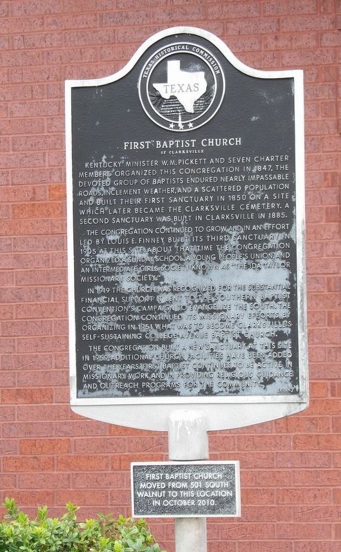
1. First Baptist Church of Clarksville Marker
The congregation continued to grow and in an effort led by Louis E. Finney built its third sanctuary in 1905 at this site. About that time the congregation organized a Sunday School, a young people's union, and an intermediate girls society know as “The Ida Taylor Missionary Society.”
In 1919 the church was recognized for the substantial financial support it lent to the Southern Baptist Convention's campaign to evangelize the South. The congregation continued its missionary efforts by organizing in 1951 what was to become Clarksville's self-sustaining College Avenue Baptist Church.
The congregation built a new sanctuary at this site in 1959; additional church facilities have been added over the years. First Baptist continues to be active in missionary work and in providing religious guidance and outreach programs for the community.
[Smaller plaque at bottom]
First Baptist Church moved from 501 South Walnut to this location in October 2010.
Erected 1994 by Texas Historical Commission. (Marker Number 10875.)
Topics. This historical marker is listed in this topic list: Religion & Religious Structures. A significant historical year for this entry is 1847.
Location. 33° 37.192′ N, 95° 4.331′ W. Marker is in Clarksville, Texas, in Red River County. It is on Capt Henry Stout Bypass (U.S. 82) ¾ mile east of North Donoho Street, on the right when traveling south. Touch for map. Marker is at or near this postal address: 1501 US-82, Clarksville TX 75426,
this page online

Regionally, this marker is in the American South and in the Piney Woods. Globally, it is in North America, a Gulf of Mexico state, the Western Hemisphere, the Western World, and the Anglosphere. Historically, it finds itself in what was once New Spain, the Republic of Texas, one of the Confederate States of America, and the Antebellum South.
Other nearby markers. At least 8 other markers are within 2 miles of this marker, measured as the crow flies: Fairground Cemetery (approx. half a mile away); City of Clarksville (approx. 0.7 miles away); David Gouverneur Burnet (approx. 1.1 miles away); St. Paul Methodist Church (approx. 1.2 miles away); Red River County Jail (approx. 1.2 miles away); Page's Tree (approx. 1.3 miles away); Clarksville Cemetery (approx. 1.3 miles away); Red River Courthouse (approx. 1.3 miles away). Touch for a list and map of all markers in Clarksville.

Photographed by Duane and Tracy Marsteller, May 1, 2026
2. First Baptist Church of Clarksville Marker
Marker is at the right corner of the building.
Credits. This page was last revised on May 21, 2026. It was originally submitted on May 20, 2026, by Duane and Tracy Marsteller of Murfreesboro, Tennessee. This page has been viewed 14 times since then. Photos: 1, 2. submitted on May 20, 2026, by Duane and Tracy Marsteller of Murfreesboro, Tennessee.
