
Kirtland in Lake County, Ohio — The American Midwest (Great Lakes)
Faith, Family, Community, and Industry
Photographed by Craig Doda, May 2, 2026
1. Faith, Family, Community, and Industry Marker
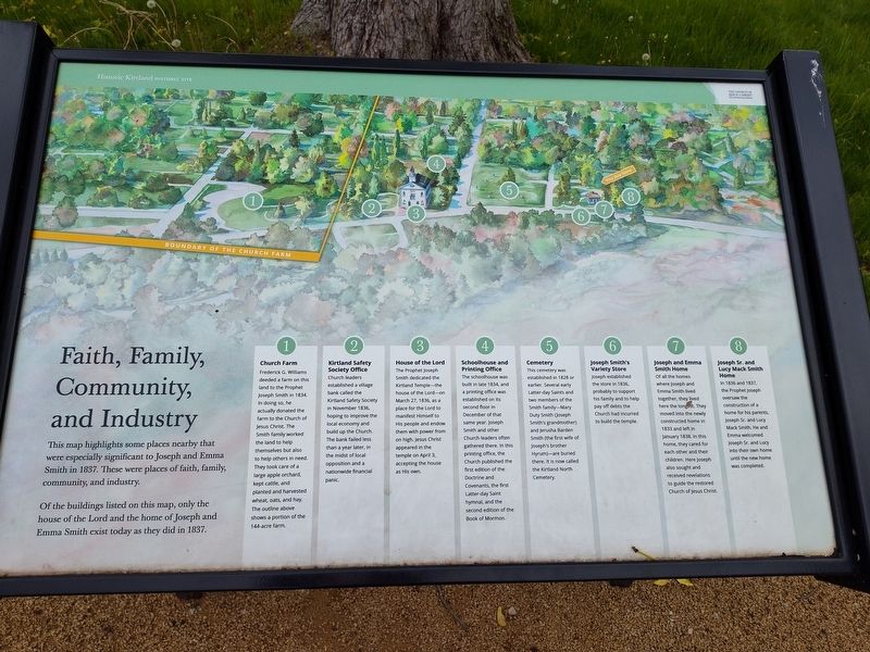
This map highlights some places nearby that were especially significant to Joseph and Emma Smith in 1837. These were places of faith, family, community, and industry.
Of the buildings listed on this map, only the house of the Lord and the home of Joseph and Emma Smith exist today as they did in 1837.
❶ Church Farm
Frederick G. Williams deeded a farm on this land to the Prophet Joseph Smith in 1834. In doing so, he actually donated the farm to the Church of Jesus Christ. The Smith family worked the land to help themselves but also to help others in need. They took care of a large apple orchard, kept cattle, and planted and harvested wheat, oats, and hay. The outline above shows a portion of the 144-acre farm.
❷ Kirtland Safety
Society Office Church leaders established a village bank called the Kirtland Safety Society in November 1836, hoping to improve the local economy and build up the Church. The bank failed less than a year later, in the midst of local opposition and a nationwide financial panic.
❸ House of the Lord
The Prophet Joseph Smith dedicated the Kirtland Temple-the house of the
this page online
❹ Schoolhouse and Printing Office
The schoolhouse was built in late 1834, and a printing office was established on its second floor in December of that same year. Joseph Smith and other Church leaders often gathered there. In this printing office, the Church published the first edition of the Doctrine and Covenants, the first Latter-day Saint hymnal, and the second edition of the Book of Mormon.
❺ Cemetery
This cemetery was established in 1828 or earlier. Several early Latter-day Saints and two members of the Smith family-Mary Duty Smith (Joseph Smith's grandmother) and Jerusha Barden Smith (the first wife of Joseph's brother Hyrum)-are buried there. It is now called the Kirtland North Cemetery.
❻ Joseph Smith's Variety Store
Joseph established the store in 1836, probably to support his family and to help pay off debts the Church had incurred to build the temple.
❼ Joseph and Emma Smith Home
Of

Photographed by Craig Doda, May 2, 2026
2. Faith, Family, Community, and Industry Marker
❽ Joseph Sr. and Lucy Mack Smith Home
In 1836 and 1837, the Prophet Joseph oversaw the construction of a home for his parents, Joseph Sr. and Lucy Mack Smith. He and Emma welcomed Joseph Sr. and Lucy into their own home until the new home was completed.
Erected by The Church of Jesus Christ of Latter-day Saints.
Topics. This historical marker is listed in these topic lists: Architecture • Industry & Commerce • Religion & Religious Structures • Settlements & Settlers. A significant historical month for this entry is January 1838.
Location. 41° 37.592′ N, 81° 21.772′ W. Marker is in Kirtland, Ohio, in Lake County. It is at the intersection of Chillicothe Road and Conley Drive, on the right when traveling south on Chillicothe Road. Touch for map. Marker is at or near this postal address: 8980 Chillicothe Rd, Willoughby OH 44094, United States of America. Touch for directions.

Regionally, this marker is in Greater Cleveland, on the Lake Erie Shore, and in the Western Reserve. It is also in the American Midwest. Globally, it is in North America, on the Great Lakes, in the Western Hemisphere, in the Western World, and in the Anglosphere. Historically, it finds itself in what was once the Haudenosaunee (Iroquois) Confederacy, the territory of the Mississippian Culture, and the Northwest Territory.
Other nearby markers. At least 8 other markers are within walking distance of this marker: Kirtland Temple (about 500 feet away, measured in a direct line); a different marker also named Kirtland Temple (about 600 feet away); Sidney and Phoebe Rigdon Home (about 700 feet away); Site of the Whitney and Gilbert Livery Stable (approx. 0.2 miles away); Kirtland Schoolhouse (approx. 0.2 miles away); Tannery (approx. 0.2 miles away); Baptisms on the East Branch of the Chagrin River (approx. 0.2 miles away); Site of the Whitney Red Store (approx. 0.2 miles away). Touch for a list and map of all markers in Kirtland.
Another marker is no longer nearby. Kirtland Temple (was about 600 feet away but has been permanently removed).
Credits. This page was last revised on June 1, 2026. It was originally submitted on May 21, 2026, by Craig Doda of Napoleon, Ohio. This page has been viewed 10 times since then. Photos: 1, 2. submitted on May 21, 2026, by Craig Doda of Napoleon, Ohio. • Devry Becker Jones was the editor who published this page.
