Regierungsvierte in Berlin in Mitte, Germany — Northeast German Plain (The European Plain)
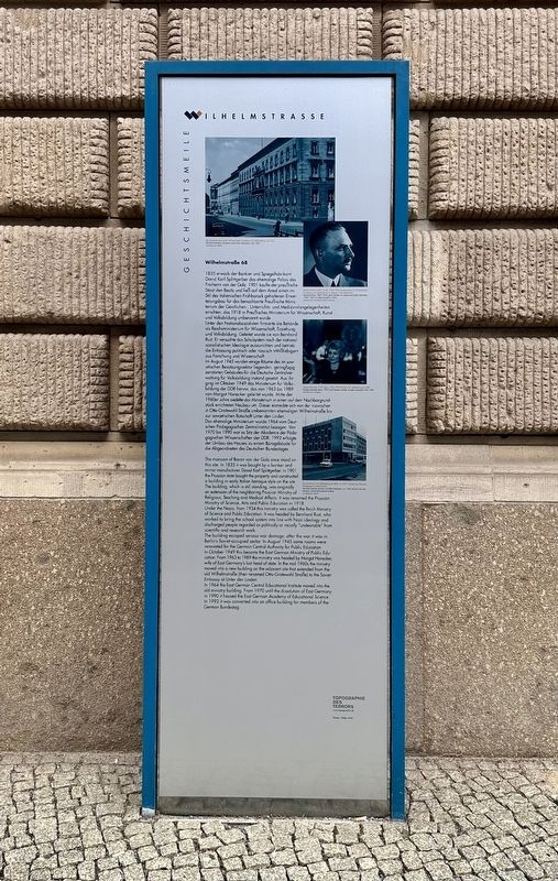
Wilhelmstraße 68
| — | Geschichtsmeile Wilhelmstraße | — |
Photographed by Andrew Ruppenstein, September 3, 2025
1. Wilhelmstraße 68 Marker

1835 erwarb der Bankier und Spiegelfabrikant David Karl Splittgerber das ehemalige Palais des Freiherrn von der Golz. 1901 kaufte der preußische Staat den Besitz und ließ auf dem Areal einen im Stil des italienischen Frühbarock gehaltenen Erweiterungsbau für das benachbarte Preußische Ministerium der Geistlichen-, Unterrichts- und Medizinalangelegenheiten errichten, das 1918 in Preußisches Ministerium für Wissenschaft, Kunst und Volksbildung umbenannt wurde.
Unter den Nationalsozialisten firmierte die Behörde als Reichsministerium für Wissenschaft, Erziehung und Volksbildung. Geleitet wurde sie von Bernhard Rust. Er versuchte das Schulsystem nach der nationalsozialistischen Ideologie auszurichten und betrieb die Entlassung politisch oder rassisch »Mißliebiger« aus Forschung und Wissenschaft.
Im August 1945 wurden einige Räume des im sowjetischen Besatzungssektor liegenden, geringfügig zerstörten Gebäudes für die Deutsche Zentralverwaltung für Volksbildung instand gesetzt. Aus ihr ging im Oktober 1949 das Ministerium für Volksbildung der DDR hervor, das von 1963 bis 1989 von Margot Honecker geleitet wurde. Mitte der 1960er Jahre siedelte das Ministerium in einen auf dem Nachbargrundstück errichteten Neubau um. Dieser erstreckte sich von der inzwischen in Otto-Grotewohl-Straße umbenannten ehemaligen Wilhelmstraße bis zur sowjetischen Botschaft Unter den Linden.
Das ehemalige Ministerium wurde 1964 vom Deutschen Pädagogischen Zentralinstitut bezogen. Von 1970 bis 1990 war es Sitz der Akademie der Pädagogischen Wissenschaften der DDR. 1992 erfolgte der Umbau des Hauses zu einem Bürogebäude für die Abgeordneten des Deutschen Bundestages.
The mansion of Baron von der Golz once stood on this site. In 1835 it was bought by a banker and mirror manufacturer,
this page online
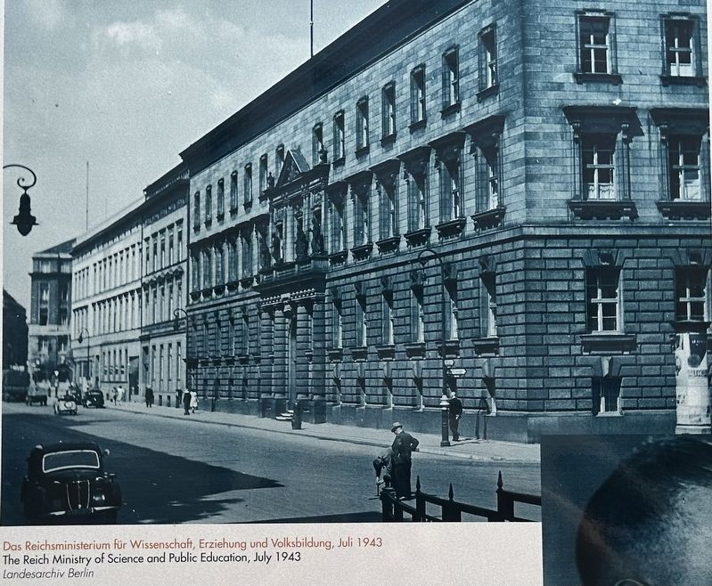
Under the Nazis, from 1934 this ministry was called the Reich Ministry of Science and Public Education. It was headed by Bernhard Rust, who worked to bring the school system into line with Nazi ideology and discharged people regarded as politically or racially "undesirable” from scientific and research work.
The building escaped serious war damage; after the war it was in Berlin's Soviet-occupied sector. In August 1945 some rooms were renovated for the German Central Authority for Public Education. In October 1949 this became the East German Ministry of Public Education. From 1963 to 1989 the ministry was headed by Margot Honecker, wife of East Germany's last head of state. In the mid-1960s the ministry moved into a new building on the adjacent site

Photographed by Andrew Ruppenstein, September 3, 2025
2. Wilhelmstraße 68 Marker - wide view
The marker is visible here to the right of the building entrance.
In 1964 the East German Central Educational Institute moved into the old ministry building. From 1970 until the dissolution of East Germany in 1990 it housed the East German Academy of Educational Science. In 1992 it was converted into an office building for members of the German Bundestag.
Topics. This historical marker is listed in this topic list: Education. A significant historical month for this entry is August 1945.
Location. 52° 30.925′ N, 13° 22.893′ E. Marker is in Berlin, in Mitte. It is in Regierungsvierte. It is at the intersection of Wilhelmstraße and Behrenstraße, on the right when traveling north on Wilhelmstraße. Touch for map. Marker is in this post office area: Berlin 10117, Germany. Touch for directions.

Regionally, it is in Europe, the European Union, Atlantic Europe, Central Europe, the Schengen Area, Western Europe, and the Western World. Historically, it finds itself in what was once the Holy Roman Empire, the former East Germany, and at the Berlin Wall.
Other nearby markers. At least
Photographed by Landesarchiv Berlin, 1943
3. Marker photo: the building when it was the Reich Ministry for Science and Public Education

courtesy Bundesarchiv Koblenz
4. Marker photo: Margot Honecker, former DDR minister for public education, 1963-1989
Credits. This page was last revised on August 16, 2026. It was originally submitted on May 21, 2026, by Andrew Ruppenstein of Lamorinda, California. This page has been viewed 50 times since then. Photos: 1, 2, 3, 4. submitted on May 21, 2026, by Andrew Ruppenstein of Lamorinda, California.
