
Centre in Cork in County Cork, Munster, Ireland — Irish South-West ((Éire) North Atlantic Ocean)
Saint Patrick’s Bridge
⎯⎯⎯
Droicead Pádraig

Photographed by Ian Lefkowitz, May 14, 2026
1. Saint Patrick’s Bridge side of marker
 Saint Patrick’s Bridge
Foundation laid
on 10 November
1859
by the Earl of Carlisle
Lord Lieutenant
Sir John Arnott M.P.
Mayor
This bridge was reconstructed in 1981
Paud Black, Lord Mayor of Cork
T. J. McHugh, City Manager and Town Clerk
Droicead Pádraig Naomta
Iarla Carlisle
Do cuir an cloc buinn
1859
An 10 lá de mí na Samna
Sir Seon Arnott Feisire
Méara
Opened for public traffic
on 12 December 1861
by Sir John Arnott M.P.
Mayor
Sir John Benson, Engineer
Joshua Hargrave
Contractor
Wm Barnard, Clerk of Works
This bridge was reconstructed in 1981
Paud Black, Lord Mayor of Cork
T. J. McHugh, City Manager and Town Clerk
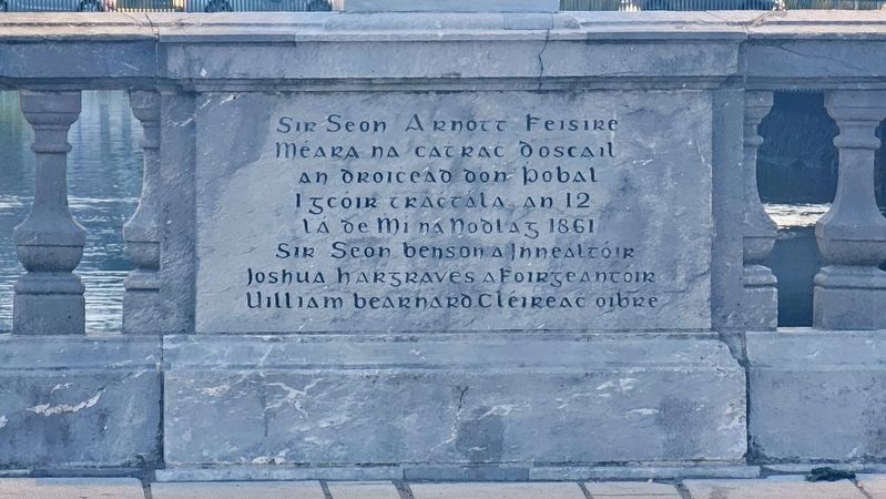
Sir Seon Arnott Feisire
Méara na catrac d’oscail
an droicead don pobal
i gcóir tráctála, an 12
lá de Mí na Nodlag 1861
Sir Seon Benson a Innealtóir
Joshua Hargraves a Foirgneantóir
Uilliam Bearnard Cléireac Oibre
Topics. This historical marker is listed in this topic list: Bridges & Viaducts. A significant historical date for this entry is December 12, 1861.
Location. 51° 54.039′ N, 8° 28.227′ W. Marker is in Cork, Munster, in County Cork. It is in Centre. It is at the intersection of
this page online

Regionally, it is on the Atlantic Ocean, in the North Atlantic Region, on the Atlantic Arc, in Europe, on the Island of Ireland, on the Celtic Fringe, in the European Union, in Atlantic Europe, on one of the British Isles, in the Western World, and in the Anglosphere. Historically, it finds itself in what was once a British colony.
Other nearby markers. At least 8 other markers are within walking distance of this marker: Father Mathew (within shouting distance of this marker); Mangan's Clock (within shouting distance of this marker); Sráid Phádraig / St Patrick’s Street / Droichead Phádraig / St Patrick’s Bridge (about 90 meters away, measured in a direct line); Rory Gallagher (about 120 meters away); 27 MacCurtain Street (about 120 meters away); Joan Denise Moriarty LL.D (about 150 meters away); The Everyman (about 150 meters away); John Lynch the Fenian / Seán Ó Loinsigh an Fínín (about 180 meters away).

Photographed by Ian Lefkowitz, May 14, 2026
2. Droicead Pádraig side of marker
Also see . . . St Patrick's Bridge, Cork City (Buildings of Ireland).
This fine bridge is a significant contributor to the architectural heritage of the city. Built in the mid nineteenth century, this bridge is representative of design, construction and materials utilised at that time. Following the laying of the foundation stone by the Earl of Carlisle, Lord Lieutenant of Ireland, over one hundred skilled stone cutters and masons were employed in the execution of this bridge, which was designed by Joseph Hargrave. This bridge retains many interesting features, such as the carved keystones and cast-iron lamp standards.(Submitted on June 6, 2026, by Ian Lefkowitz of New York, New York.)

Photographed by Ian Lefkowitz, May 14, 2026
3. Opened for Public Traffic Marker
Photographed by Ian Lefkowitz, May 14, 2026
4. Sir Seon Arnott Feisire Marker

Photographed by Ian Lefkowitz, May 14, 2026
5. Saint Patrick’s Bridge / Droicead Pádraig Marker
Inscriptions may be found on each of the bridge's parapets.
Credits. This page was last revised on July 25, 2026. It was originally submitted on June 6, 2026, by Ian Lefkowitz of New York, New York. This page has been viewed 18 times since then. Photos: 1, 2, 3, 4, 5. submitted on June 6, 2026, by Ian Lefkowitz of New York, New York. • Andrew Ruppenstein was the editor who published this page.
