Den Burg in Texel, North Holland, Netherlands — Northwestern Europe
Nederlandse Hervormde Kerk van den Burg
⎯⎯⎯
Dutch Reformed Church of Den Burg
Photographed by Andrew Ruppenstein, June 1, 2026
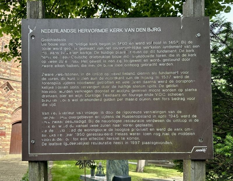
1. Nederlandse Hervormde Kerk van den Burg / Dutch Reformed Church of Den Burg Marker

Geschiedenis
De bouw van de huidige kerk begon in 1400 en werd voltooid in 1452. Bij de bouw werd gebruik gemaakt van net oorspronkelijke veldkeien fundament van een Romaans tufstenen kerkje. De huidige pilaren rusten op dit fundament. De kerk heeft een laat-Gotische driebeukige bouw met ingebouwde toren. die in de kerk op twee zuilen rust. Het gewelf is een z.g. tongewelf en wordt gesteund door zware eiken balken, die met de bouw mee omhoog gebracht werden.
Zware zwerfstenen, in de ijstijd op Texel beland, dienen als fundament voor de toren. dit kunt u zien aan de noordkant van de ingang. In 1537 werd de torenspils tijdens noodweer getroffen en vele jaren daarna werd de oorspronkelijke houten spits vervangen door de huidige stenen spits. De gelden hiervoor werden verkregen doordat er accijns geneven mocht worden op sterke dranken, bier en wijn. Dorstige Texelaars en fourage, ende V.O.C. schepen brachten soms wel driehonderd gulden per maand bijeen, een fors bedrag voor die tijd.
Van het interieur van vroeger is door de rigoureuze vernielingen van de Geuzen
this page online
Na de oorlog had de woningbouw de hoogste prioriteit en werd de kerk omstreeks het jaar 1950 gerestaureerd. Helaas waren toen nog niet de middelen voorhanden om tot een effectief herstel te komen.
De laatste (gedeeltelijke) restauratie heeit in 1997 plaatsgevonden.
(English translation:)
Dutch Reformed Church of Den Burg
History Construction of the current church began in 1400 and was completed in 1452. The original fieldstone foundation of a small Romanesque tuff-stone church was utilized during construction; the current pillars rest upon this foundation. The church features a Late Gothic three-aisle design with an integrated tower that rests on two columns within the church interior. The vault is a barrel vault, supported by heavy oak beams that were hoisted into place as construction progressed.
Heavy glacial erratics, deposited on Texel during the Ice Age, serve as the tower's foundation; this can be seen on the

Photographed by Andrew Ruppenstein, June 1, 2026
2. Nederlandse Hervormde Kerk van den Burg / Dutch Reformed Church of Den Burg Marker
Nothing remains of the original interior due to the wholesale destruction wrought by the Geuzen (Sea Beggars), and the church suffered heavy damage during the Georgian Uprising in April 1945. During the post-war restoration, the interior gallery was removed, and the pulpit was moved forward by two columns.
After the war, housing construction took priority, and the church was restored around 1950. Unfortunately, the resources required for a truly effective restoration were not yet available at that time.
The most recent (partial) restoration took place in 1997.
Erected by the ANWB. (Marker Number 62174/01.)
Topics. This historical marker is listed in this topic list: Religion & Religious Structures. A significant historical month for this entry is April 1945.
Location. 53° 3.288′ N,

Photographed by Andrew Ruppenstein, June 1, 2026
3. Nederlandse Hervormde Kerk van den Burg / Dutch Reformed Church of Den Burg

Regionally, this marker is on the German Wadden Sea. Globally, it is in Europe, the European Union, Atlantic Europe, the Benelux Low Countries, the Schengen Area, Western Europe, and the Western World. Historically, it finds itself in what was once the Holy Roman Empire.
Other nearby markers. At least 8 other markers are within 5 kilometers of this marker, measured as the crow flies: Dr. Lejzer Zamenhof Monument (about 240 meters away, measured in a direct line); De Goede Herder / The Good Shepherd War Memorial (approx. 0.4 kilometers away); Molen de Traanroeier / Windmill de Traanroeier / Mühle de Traanroeier (approx. 3.9 kilometers away); Bakker Steegie / Bakker Alley (approx. 3.9 kilometers away); De Noorderhaven / The “North Harbor” (approx. 3.9 kilometers away); Vliegtuigcrash Lancaster JA932 MG-M Gedenkteken / Lancaster JA932 MG-M Crash Memorial

Photographed by Andrew Ruppenstein, June 1, 2026
4. Churchyard
Also see . . . De Burght (Den Burg) (Wikipedia, in Dutch). (Submitted on June 11, 2026.)
Credits. This page was last revised on June 11, 2026. It was originally submitted on June 11, 2026, by Andrew Ruppenstein of Lamorinda, California. This page has been viewed 8 times since then. Photos: 1, 2, 3, 4. submitted on June 11, 2026, by Andrew Ruppenstein of Lamorinda, California.
