Quentin in Lebanon County, Pennsylvania — The American Northeast (Mid-Atlantic)
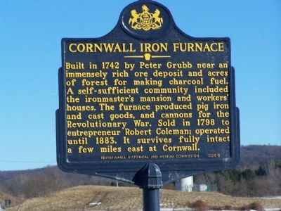
Cornwall Iron Furnace
Erected 2005 by Pennsylvania Historical and Museum Commission.
Topics and series. This historical marker is listed in these topic lists: Colonial Era • Industry & Commerce • Natural Resources • War, US Revolutionary. In addition, it is included in the Pennsylvania Historical and Museum Commission series list. A significant historical year for this entry is 1742.
Location. 40° 16.872′ N, 76° 26.855′ W. Marker is in Quentin, Pennsylvania, in Lebanon County. Marker is on U.S. 322 close to Pennsylvania Route 419. Touch for map. Marker is in this post office area: Quentin PA 17083, United States of America. Touch for directions.
Other nearby markers. At least 8 other markers are within 3 miles of this marker, measured as the crow flies. This Town Renamed Quentin (approx. 0.6 miles away); The Shay Brothers (approx. 1.6 miles away); Cornwall Furnace (approx. 2.2 miles away); a different marker also named Cornwall Furnace (approx. 2.3 miles away); a different marker also named Cornwall Furnace (approx. 2.3 miles away); Roasting Oven (approx. 2.3 miles away); Abattoir (approx. 2.3 miles away); Cornwall Banks (approx. 2.4 miles away).
Credits. This page was last revised on June 16, 2016. It was originally submitted on May 1, 2010, by Bill Pfingsten of Bel Air, Maryland. This page has been viewed 833 times since then and 16 times this year. Photo 1. submitted on May 1, 2010, by Bill Pfingsten of Bel Air, Maryland.
