Lawrence Township in Mercer County, New Jersey — The American Northeast (Mid-Atlantic)
Lewisville Road
| — | Lawrence Hopewell Trail | — |
Photographed by Richard Peterson, June 14, 2026
1. Lewisville Road Marker
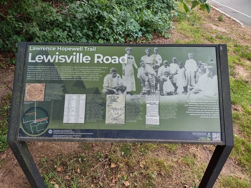
Ranged along this stretch of roadway is the small village of Lewisville, Lawrence Township's earliest African American community, founded by former enslaved persons and their descendants from Lawrence and the surrounding townships. They began acquiring land and small farms along this stretch in the 1840s. Despite difficult social and economic conditions, these pioneering families set down roots and prospered. By the 1890s, the village consisted of about a dozen houses and the Mount Pisgah African Methodist Episcopal (A.M.E.) Church, a vibrant center for African American culture.
Lewisville is named after Lewis W. R. Phillips, a former slaveholder who freed his slaves and joined the abolitionist movement in the 1820s. Phillips began selling small lots of land to Blacks in the 1840s along what became Lewisville Road. This detail of a map published in 1860 is one of the earliest to call out the village of Lewisville and name Black property owners. Prominent names include Schenck, Van Horn and Wright.
(Caption) D. J. Lake and S. N. Beers, Map of Vicinity of Philadelphia and Trenton, 1860.
A U.S. Census taker who passed
this page online
(Caption) U. S. Census Bureau, Population Schedule, Lawrence Township, Mercer County, New Jersey, 1860.
The 1890s were the height of the Jim Crow era, which is associated with the creation of new segregation laws and denial of equal rights to people of color. While New Jersey may not have been as restrictive as states in the South, strong attitudes about keeping the races physically separate are reflected in this map. Note that Lewisville appears only as a row of houses labeled “Negroes,” an indication of a dominant racist mindset. During
Photographed by Richard Peterson, June 14, 2026
2. Lewisville Road Marker
(Caption) Scarlett & Scarlett's Fire Map of Mercer County, 1890.
The Mount Pisgah A.M.E. Church was famous for its fundraisers, camp meetings and harvest home festival. Local newspapers, like the Trenton Evening Times, frequently advertised church events. They were highly anticipated occasions -- religious revival, political meeting and carnival all rolled into one. The church used Oliphant's Grove, an outdoor space off of Lewisville Road. In 1905, the newspaper reported that the church ladies cooked dinner for 3,000 people. The home cooking featured poultry and vegetables donated by local farmers.
(Caption) Trenton Evening Times, 16 July 1906 (top), 1 April 1908 (center) and 5 April 1911 (bottom).
The Bosley family, shown here at a gathering, moved to Lewisville in 1913 when Amos and Charlotte Bosley purchased a house. As the Bosley children grew up and married, the family branched out along the road, taking over many of the original Lewisville properties.
This project was funded by the FHWA Recreational Trails Program, through the New Jersey Department of Environmental Protection. Content development by Hunter Research, Inc. Graphic design by Douglas Scott
History Along the LHT / Learn more by visiting lhtrail.org/history / Proud to Trail / The Circuit Trails
Erected by Lawrence Hopewell Trail.
Topics. This historical marker is listed in these topic lists: African Americans • Religion & Religious Structures • Settlements & Settlers. A significant historical year for this entry is 1840.
Location. 40° 17.452′ N, 74° 43.01′ W. Marker is in Lawrence Township, New Jersey, in Mercer County. It is on Lewisville Road 0.7 miles east of Franklin Corner Road (County Route 546), on the right when traveling east. Located on the Lawrence Hopewell Trail where it crosses Lewisville Road. Touch for map. Marker is at or near this postal address: 60 Lewisville Rd, Lawrence Township NJ 08648, United States of America. Touch for directions.

Regionally, this marker is in Central Jersey and in Greater Princeton. It is also in the American Northeast and in the Mid-Atlantic. Globally, it is in North America, the Western Hemisphere, the Western World, and the Anglosphere. Historically, it finds itself in what was once New Netherland and also one of the original Thirteen Colonies.
Other nearby markers. At least 8 other markers are within walking distance of this marker: A different marker also named Lewisville Road (approx. 0.2 miles away); Brearley Oak (approx. 0.4 miles away); Princeton Pike (approx. 0.4 miles away); Spring Grove (approx. 0.4 miles away); Maidenhead Church (approx. 0.8 miles away); John Moore’s Tavern (approx. 0.8 miles away); Lawrence House, 1840 (approx. 0.8 miles away); First Town Hall (approx. 0.8 miles away). Touch for a list and map of all markers in Lawrence Township.
Also see . . . History along the LHT. A listing of historical markers along the Lawrence Hopewell Trail.
Based on research by historical and archaeological consultants at Hunter Research, Inc., History Along the LHT is placing historical markers at several dozen locations along the trail. Here are the historical markers that are currently installed, markers that will be installed soon, and other points of interest in the history of Hopewell and Lawrence.(Submitted on June 18, 2026, by Richard Peterson of East Windsor, New Jersey.)
Credits. This page was last revised on June 28, 2026. It was originally submitted on June 18, 2026, by Richard Peterson of East Windsor, New Jersey. This page has been viewed 20 times since then. Photos: 1, 2. submitted on June 18, 2026, by Richard Peterson of East Windsor, New Jersey. • Michael Herrick was the editor who published this page.
