Ridgeway in Fort Erie in Niagara Region, Ontario — Central Canada (North America)
282 Ridge Road
Downtown Ridgeway Business Improvement Area
Photographed by Kevin Westell, June 23, 2026
1. 282 Ridge Road - Marker
Inscription.
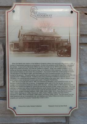
When the Bertie train station of the Buffalo & Goderich railway line was built in Ridgeway in 1856, a
number of businesses sprang up surrounding it, of which this property at 282 Ridge Road was one of
the earliest. It was built by Alexander Willson as the City Hotel, but by 1878 it was owned by Aaron
Anger who rented out rooms, and had ten children to support. Anger was unable to obtain a liquor
license as the town already had its quota of two, so he resorted to dire measures - he hired a Buffalo
man named Freebury to burn down the competition - the Queen's Hotel kitty-corner across the tracks.
The fire was lit in the dead of night, and fortunately all of the occupants escaped, but the Queen's
burned to the ground. The guilty parties were apprehended and a sensational extradition in Buffalo and
separate trials in Welland ensued. Freebury was cross-examined in Buffalo by attorney Grover Cleveland
who would become president of the United States a few years later. Back in Welland Anger
and Freebury were sentenced to seven years each in Kingston Penitentiary.
John McLeod bought this hotel in 1881 and restored
Click or scan to see this page online
its reputation, and it would be known as the
McLeod House for more than a century. A newspaper article said of him that he was "genial and upright, and conducted his business strictly within the law". Another article in 1910 boasted that the
McLeod was heated and lighted by natural gas and had the finest of table, wines and cigars. The hotel
also had a sample room where travelling salesmen would display their wares for local business owners,
an ice house, and stables where weary horses could be groomed and fed. Other proprietors of more
than 5 years duration included Huffman (1900-1906), Athoe (1906-1911), Percy Rice for 35 years (1911-1946), Hathews (in 1946), Macona (in 1954), Kafun (1960's), Collins and Teal (1970's), Serediuk (in 1984), Rose and Gerger (1990-2004), and Brown (2004-2012). The old railway line has
been paved for use as a recreational trail, and Matthew and Trisha O'Brien and family renovated the
property and opened the popular Trailside Bar & Grill in 2012.
Picture from Cathy Herbert Collection
Research & text by Ada Sherk
Topics. This historical marker is listed in this topic list: Notable Buildings. A significant historical year for this entry is 1856.
Location. 42° 52.948′ N,
Photographed by Kevin Westell, June 23, 2026
2. 282 Ridge Road - Marker in context
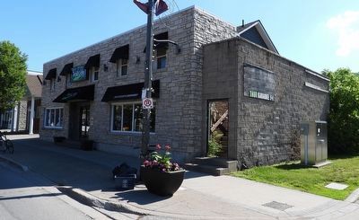
Photo faces north-east. Marker (left) is beside main entrance. Ridge Road is on the left; parking is out-of-frame right.
79° 3.114′ W. Marker is in Fort Erie, Ontario, in Niagara Region. It is in Ridgeway. It is on Ridge Road North, on the right when traveling north. Touch for map. Marker is at or near this postal address: 282 Ridge Rd N, Fort Erie ON L0S 1N0, Canada. Touch for directions.
Regionally, this marker is on Ontario’s Golden Horseshoe and in Niagara Canada. It is also in Central Canada. Globally, it is in North America, on the Great Lakes, in the Western Hemisphere, in the Western World, and in the Anglosphere. Historically, it finds itself in what was once a British colony, the Viceroyalty of New France, the Haudenosaunee (Iroquois) Confederacy, and Rupert’s Land.
Credits. This page was last revised on June 24, 2026. It was originally submitted on June 24, 2026, by Kevin Westell of St. Catharines, Ontario. This page has been viewed 6 times since then. Photos:1, 2. submitted on June 24, 2026, by Kevin Westell of St. Catharines, Ontario.