Bridgeburg in Fort Erie in Niagara Region, Ontario — Central Canada (North America)
R.C.A.F. "Red Knight" T-33 Jet Aircraft
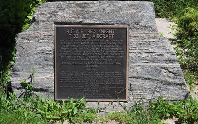
Photographed by Kevin Westell, June 23, 2026
1. R.C.A.F. "Red Knight" T-33 Jet Aircraft - Marker
This aircraft a proudly dedicated to, our veterans. military and the aviation industry of Fort Erie
Officially Dedicated by R.C.A.F.A. 484 (Frontier) Wing, May 2001.
"High Flight"
Oh! I have slipped the surly bonds of earth, and danced the skies on laughter-silvered Wings; Sunward I've climbed, and joined the rumbling mirth of sun-split clouds - and done a hundred things You have not dreamed of - wheeled and soared and swung High in the sunlit silence. Hov'ring there I've chased the shouting wind along, and flung My eager craft through footless halls of air. Up, up the long delirious, burning blue, I've topped the windwsept heights with easy grace, where never Lark or even Eagle flew. And while with silent lifting mind I've trod the high-untrespassed sanctity of Space.
this page online
Pilot Officer Gillespie (John) Magee Junior
No. 412 Sqd. R.C.A.F. killed on Dec. 10th 1941.
Erected 2001 by R.C.A.F.A. 484 (Frontier) Wing.
Topics. This historical marker is listed in this topic list: Air & Space. A significant historical year for this entry is 1954.
Location. 42° 55.341′ N, 78° 55.097′ W. Marker is in Fort Erie, Ontario, in Niagara Region. It is in Bridgeburg. It is on Central Avenue. Touch for map. Marker is at or near this postal address: 469 Central Ave, Fort Erie ON L2A 3T7, Canada. Touch for directions.

Regionally, this marker is on the Golden Horseshoe and in Niagara Canada. It is also in Central Canada. Globally, it is in North America, on the Great Lakes, in the Western Hemisphere, in the Western World, and in the Anglosphere. Historically, it finds itself in what was once a British colony, the Viceroyalty of New France, the Haudenosaunee (Iroquois) Confederacy, and Rupert’s Land.
Other nearby markers. At least 8 other markers are within walking distance of this marker: B-1 Grand Trunk Station (within shouting distance of this marker);

Photographed by Kevin Westell, June 23, 2026
2. T-33 Jet Trainer
The marker (centre) is on a rock under the starboard wing of jet-trainer-on-a-stick.
Regarding R.C.A.F. "Red Knight" T-33 Jet Aircraft. The Lockheed T-33 "Shooting Star" was known within Canada as the Canadair CT-133 "Silver Star". This follows the post-war tradition for Canada to clone US aircraft under license, with a Canadian manufacturer, designation and name.
Also see . . . Lockheed T-33 Jet Trainer (by Wikipedia). (Submitted on June 25, 2026, by Kevin Westell of St. Catharines, Ontario.)

Photographed by Kevin Westell, June 23, 2026
3. T-33 Jet Trainer
Credits. This page was last revised on June 25, 2026. It was originally submitted on June 25, 2026, by Kevin Westell of St. Catharines, Ontario. This page has been viewed 8 times since then. Photos: 1, 2, 3. submitted on June 25, 2026, by Kevin Westell of St. Catharines, Ontario.
