Downtown West in Minneapolis in Hennepin County, Minnesota — The American Midwest (Upper Plains)
Minneapolis YMCA Central Building
1919, 1957, 1990, 1994

Photographed by McGhiever, June 9, 2024
1. Minneapolis YMCA Central Building Marker
The twelve story YMCA Building was designed in the Late Gothic Revival style and completed in 1919. The building is composed of predominately reinforced concrete with distinct layers of base, shaft and top. The architects selected the Gothic style to emphasize the verticality and the symbolic association with churches. Construction was delayed by the start of WWI in 1917.
Materials had become tight in 1917. To address the financial need, the general contractor, J.L. Robinson, agreed to waive the general contractor fees and work on a cost and percentage basis. Robinson sold the company to Kraus Anderson in 1929, which continues to operate locally and nationally. The interior accommodated 382 rooms including 250 dormitory rooms.
In 1957, balconies on the eleventh floor were removed and replaced by limestone and brick. In 1990, the bay on the north side of the building was removed, and the interior was demolished. Two Gothic fireplaces remained. In 1994, the YMCA Building was converted into 122 apartments. In 1995, the YMCA Building was placed on the National Register of Historic Places.
Erected by the Downtown
this page online
Topics. This historical marker is listed in these topic lists: Architecture • War, World I. A significant historical year for this entry is 1919.
Location. 44° 58.546′ N, 93° 16.519′ W. Marker is in Minneapolis, Minnesota, in Hennepin County. It is in Downtown West. It is at the intersection of La Salle Avenue and S. 9th Street on La Salle Avenue. The marker is on the south corner of the building, which is now the LaSalle Apartments. Touch for map. Marker is at or near this postal address: 36 S 9th Street, Minneapolis MN 55402, United States of America. Touch for directions.

Regionally, this marker is in the Twin Cities Metropolitan Area. It is also in the American Midwest, in the Corn Belt, and in the Great River Road Region. Globally, it is in North America, the Western Hemisphere, the Western World, and the Anglosphere. Historically, it finds itself in what was once Rupert’s Land, the territory of the Mississippian Culture, and the Louisiana Purchase.
Other nearby markers. At least 8 other markers are within walking distance of this marker: State Theatre (about 400 feet away,

Photographed by McGhiever, June 9, 2024
2. Minneapolis YMCA Central Building Marker at the south corner of the building
Also see . . . Minneapolis YMCA Central Building (QR code on marker). (Submitted on June 27, 2026, by McGhiever of Minneapolis, Minnesota.)
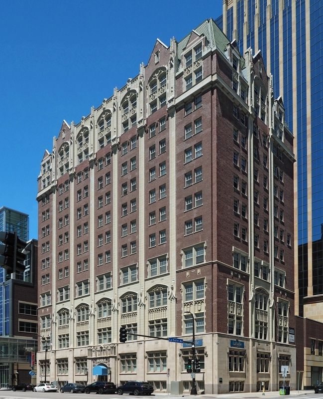
Photographed by McGhiever, June 9, 2024
3. The Minneapolis YMCA Central Building
Credits. This page was last revised on June 27, 2026. It was originally submitted on June 27, 2026, by McGhiever of Minneapolis, Minnesota. This page has been viewed 10 times since then. Photos: 1, 2, 3. submitted on June 27, 2026, by McGhiever of Minneapolis, Minnesota.
