Cass in Pocahontas County, West Virginia — The American South (Appalachia)
Cass
Photographed by Jimmy Emerson, July 17, 2011
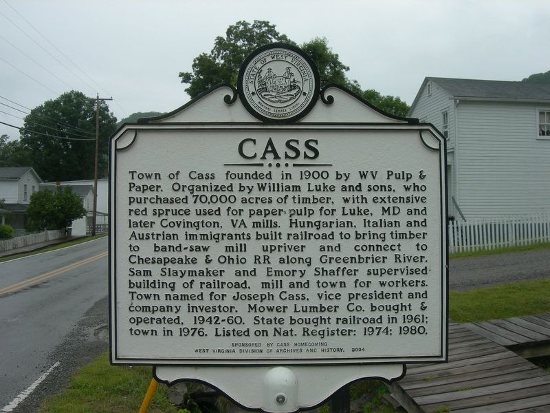
1. Cass Marker
Town of Cass founded in 1900 by WV Pulp & Paper. Organized by William Luke and sons, who purchased 70,000 acres of timber, with extensive red spruce used for paper pulp for Luke, MD and later Covington, VA mills. Hungarian, Italian and Austrian immigrants built railroad to bring timber to band-saw mill upriver and connect to Chesapeake & Ohio RR along Greenbrier River. Sam Slaymaker and Emory Shaffer supervised building of railroad, mill and town for workers. Town named for Joseph Cass, vice president and company investor. Mower Lumber Co. bought & operated, 1942-60. State bought railroad in 1961: town in 1976. Listed on Nat. Register: 1974; 1980.
Erected 2004 by Cass Homecoming and WV Division of Archives and History.
Topics and series. This historical marker is listed in these topic lists: Horticulture & Forestry • Industry & Commerce • Railroads & Streetcars • Settlements & Settlers. In addition, it is included in the West Virginia Archives and History series list. A significant historical year for this entry is 1900.
Location. 38° 23.779′ N, 79° 55.05′ W. Marker is in Cass, West Virginia, in Pocahontas
this page online

Regionally, this marker is in West Virginia’s Potomac Highlands. It is also in the American South, specifically in the Upper South, in Appalachia, and specifically in Southern Appalachia. Globally, it is in North America, the Western Hemisphere, the Western World, and the Anglosphere. Historically, it finds itself in what was once the territory of the Mississippian Culture.
Other nearby markers. At least 8 other markers are within 13 miles of this marker, measured as the crow flies: Ewen-Purcell Horn Antenna (approx. 5.9 miles away); Lee's Headquarters (approx. 7 miles away); Pocahontas County / Randolph County (approx. 7.4 miles away); a different marker also named Lee's Headquarters (approx. 7.8 miles away); Mingo Flats (approx. 9.8 miles away); Battle for the High Ground (approx. 11.8 miles away); Valley Head (approx. 12.2 miles away); Spirited Artillery Duel

Photographed by Jimmy Emerson, July 17, 2011
2. Cass Marker w. Company houses
Other markers no longer nearby. Camp Allegheny 1861-1862 (was approx. 11.8 miles away but has been replaced with another marker now near it); Camp Allegheny (was approx. 11.8 miles away but has been replaced with another marker now near it).
Also see . . . Cass Historic District NRHP Nomination Form. Excerpt:
Cass stands out, too, as a good representative of timber development, both in its architecture and history. Its more-or-less isolated location points to a time when industry moved with its resources, when length of transportation of the raw product was shortened in favor of longer shipment of processed goods, when log rafts on the rivers were significantly replaced by railroad lines to timberlands. And although Cass remained (remains) rather isolated, its viability as a timbering and processing center outlasted that of most such towns. What is more, its continued association with the industry meant little change in its housing stock, construction methods, architectural "styles," and building interrelationships. What one sees today at Cass is basically what one would have seen in 1910 or 1950: a grading of simple, company-town frame houses with class orientation (the managerial class housed in larger dwellings on higher elevations with smaller laborers' quarters near the railroad and river).(Submitted on July 8, 2026, by Jimmy Emerson of Dalton, Georgia.)
By way of summary, then, it may be said that Cass is a reflection of timbering culture in West Virginia's mountainous interior that was spawned late in the nineteenth century and continued into recent decades of the twentieth century. This reflection is represented by the timber on surrounding mountainsides that provided sustenance, the railroad and its gear-driven locomotives that brought the resource to the town for processing, and the existing buildings in the community that bear witness to the evolution of sixty years of company-town association with that industry in this area.
Credits. This page was last revised on July 14, 2026. It was originally submitted on July 2, 2026, by Jimmy Emerson of Dalton, Georgia. This page has been viewed 23 times since then. Photos: 1, 2. submitted on July 2, 2026, by Jimmy Emerson of Dalton, Georgia. • Devry Becker Jones was the editor who published this page.
