Manzanar National Historic Site near Independence in Inyo County, California — The American West (Pacific Coastal)
Made in Manzanar
Sustaining a "City" of 10,000
Photographed by Craig Baker, May 15, 2026
1. Made in Manzanar Marker
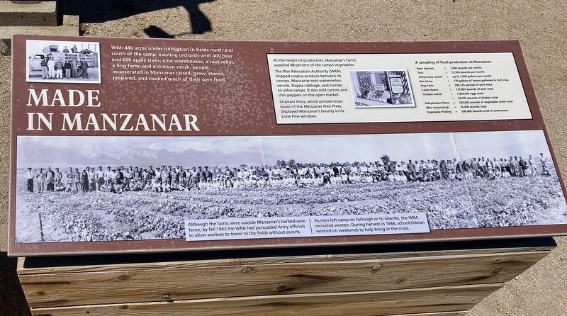
With 440 acres under cultivation in fields north and south of the camp, existing orchards with 400 pear and 600 apple trees, nine warehouses, a root cellar, a hog farm, and a chicken ranch, people incarcerated in Manzanar raised, grew, stored, prepared, and cooked much of their own food.
At the height of production, Manaanar's farms supplied 80 percent of the camp's vegetables.
The War Relocation Authority (MRA) shipped surplus produce between its centers, Manzanar sent watermelon carrots, Nappa cabbage, and to other camps. It also sold carrots and chili peppers on the open market Chalfant Press, which printed most Issues of the Manzanar Free Press displayed Manzanar's bounty in its Lone Pine window.
Although the farms were outside Manzanar's barbed wire fence, by fall 1942 the WRA had persuaded Army officials to allow workers to travel to the fields without escorts. As men left camp on furlough or to resettle, the WRA recruited women. During harvest in 1944, schoolchildren worked on weekends to help bring in the crops.
Sustaining a "City" of 10,000
The War Department chose
this page online
To supplement what the camp produced, the chief steward ordered canned goods through the US Army Quartermaster in southern California, and purchased milk and produce from Owens Valley farms.
Each morning, trucks delivered food to the mess halls. Twice a day, they hauled away the best garbage to the hog farm. "This garbage is found to be excellent pig food — much better than that found in city garbage," pig-farm foreman Shutaro Matsumura reported.
Another man noted the efficiency of the setup: "The hogs ate everything we left and ultimately we ate the hogs."
Erected by National Park Service.
Topics. This historical marker is listed in these topic lists: Asian Americans • War, World II. A significant historical month for this entry is June 1543.
Location. 36° 43.66′ N, 118° 9.052′ W.

Photographed by Craig Baker, May 15, 2026
2. Manzanar Marker

Regionally, this marker is in California’s Sierra Nevada. It is also in the American Mountain West. Globally, it is in North America, on the Ring of Fire, on the Pacific Rim, in the Western Hemisphere, in the Western World, and in the Anglosphere. Historically, it finds itself in what was once New Spain and also Mexico’s Alta California.
Other nearby markers. At least 8 other markers are within walking distance of this marker: Mess Halls of Manzanar (a few steps from this marker); "Waiting in a Breadline" (a few steps from this marker); Pressing Needs (a few steps from this marker); Community Activities (a few steps from this marker); "Zeal for Cleanliness" (within shouting distance of this marker); Enduring Humiliation (within shouting distance of this marker); "That's What You Call Survival" (about 400 feet away,

Photographed by Craig Baker, May 15, 2026
3. Made in Manzanar Marker
Credits. This page was last revised on July 5, 2026. It was originally submitted on July 4, 2026, by Craig Baker of Sylmar, California. This page has been viewed 13 times since then. Photos: 1, 2, 3. submitted on July 4, 2026, by Craig Baker of Sylmar, California.
