Spaarndam in Haarlemmermeer, North Holland, Netherlands — Northwestern Europe
Het Rijnlandshuis
⎯⎯⎯
The Rijnland House

Photographed by Andrew Ruppenstein, May 31, 2026
1. Het Rijnlandshuis / The Rijnland House Marker

Built in 1641 as a workshop, carpentry shed, and storage facility for the Rijnland Water Board, the structure reflects the style of Pieter Post. To its right stood the actual Gemeenlandshuis (Water Board headquarters) of Rijnland, known around 1600 as "Het Huys te Oosterwaal"; this building was gradually demolished after 1728. Rijnland supervisors such as Nicolaas Cruquius and Christiaan Brunings Jr. lived here. The small bell on the roof, dated 1524, was used to summon the
this page online
Erected by the ANWB, VVV.
Topics. This historical marker is listed in this topic list: Notable Buildings. A significant historical year for this entry is 1641.
Location. 52° 24.768′ N, 4° 40.965′ E. Marker is in Spaarndam, Noord-Holland (North Holland), in Haarlemmermeer. It is on Spaarndammerdijk, on the left when traveling west. Touch for map. Marker is at or near this postal address: Spaarndammerdijk 23, Spaarndam, Noord-Holland 2064 KM, Netherlands. Touch for directions.

Regionally, it is in Europe, the European Union, Atlantic Europe, the Benelux Low Countries, the Schengen Area, Western Europe, and the Western World. Historically, it finds itself in what was once the Holy Roman Empire.
Other nearby markers. At least 8 other markers are within walking distance of this marker: De Grote Haarlemmersluis / The Grote Haarlemmersluis (within shouting distance of this marker); Het Rijnlandshuis / The Rijnlandshuis (within shouting distance of this marker);

Photographed by Andrew Ruppenstein, May 31, 2026
2. Het Rijnlandshuis / The Rijnland House Marker - wide view
Also see . . . Gemeenlandshuis Spaarndam (Wikipedia, in Dutch). Excerpt (in translation):
The Gemeenlandshuis Spaarndam was one of the historic administrative buildings (gemeenlandshuizen) of the Rijnland Water Board, situated along the Spaarndammerdijk near the village of Spaarndam. Given the dike's frequent vulnerability to flooding and the proximity of the Spaarndam sluices, a facility was needed here to serve as a meeting place for the Rijnland board and a residence for the overseer. Renowned hydraulic engineers such as Brunings, Conrad, and Cruquius lived in this house. The site also included a carpentry workshop and storage(Submitted on July 7, 2026.)space for dike maintenance materials.Photographed by Andrew Ruppenstein, May 31, 20263. Het Rijnlandshuis / The Rijnland House Marker - wide view
Originally, the 'Huis te Oosterwaal' (dating from 1552) stood on this site. In 1641, it was expanded with the addition of the Gemeenlandshuis Spaarndam—which still stands today—after which the old house was demolished between 1728 and 1805.
The building's importance declined following the reclamation of the IJ and the construction of the North Sea Canal. The Gemeenlandshuis Spaarndam has been a listed national monument since 1973.


Photographed by Andrew Ruppenstein, May 31, 2026
4. Het Rijnlandshuis / The Rijnland House (from across the street from the marker)
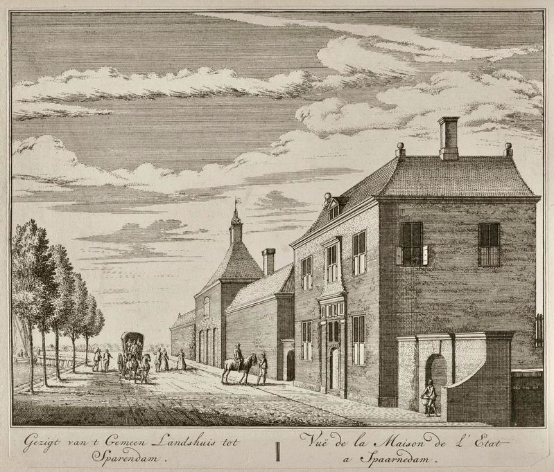
Abraham Rademaker (courtesy Voorhelm Schneevogt via Wikimedia Commons), 1740
5. View of the Rijnland House
Credits. This page was last revised on July 7, 2026. It was originally submitted on July 7, 2026, by Andrew Ruppenstein of Lamorinda, California. This page has been viewed 12 times since then. Photos: 1, 2, 3, 4, 5. submitted on July 7, 2026, by Andrew Ruppenstein of Lamorinda, California.
