San Fernando in Pampanga, Central Luzon, Philippines — Southeast Asia
Province of Pampanga
Lalawigan ng Pampanga
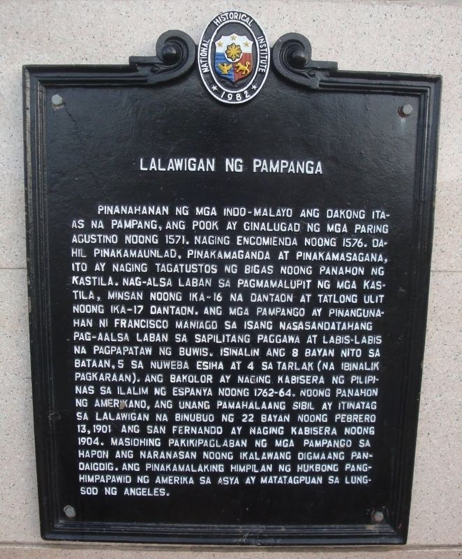
Photographed by Marco D. Nepomuceno
1. Lalawigan ng Pampanga Marker
 Pinanahanan ng mga Indo-Malayo ang dakong itaas na pampang, ang pook ay ginalugad ng mga paring Agustino noong 1571. Naging encomienda noong 1576. Dahil pinakamaunlad, pinakamaganda at pinakamasagana, ito ay naging tagatustos ng bigas noong panahon ng Kastila. Nag-alsa laban sa pagmamalupit ng mga Kastila, minsan noong ika-16 na dantaon at tatlong ulit noong ika-17 dantaon. Ang mga Pampango ay pinangunahan ni Francisco Maniago sa isang nasasandatahang pag-aalsa laban sa sapilitang paggawa at labis-labis ng pagpapataw ng buwis. Isinalin ang 8 bayan nito sa Bataan, 5 sa Nuweba Esiha, at 4 sa Tarlak (na ibinalik pagkaraan). Ang Bakolor ay naging Cabisera ng Pilipinas sa ilalim ng Espanya noong 1762–64. Noong panahon ng Amerikano, ang unang Pamahalaang Sibil ay itinatag sa lalawigan na binubuo ng 22 bayan noong Pebrero 13, 1901. Ang San Fernando ay naging Cabisera noong 1904. Masidhing pakikipaglaban ng mga Pampango sa Hapon ang naranasan noong Ikalawang Digmaang Pandaigdig. Ang pinakamalaking himpilan ng Hukbong Pang-Himpapawid ng Amerika sa Asya ay matatagpuan sa Lungsod ng Angeles.
Province
this page online
A place above the riverbank settled by Indo-Malays, it was explored by Augustinian friars in 1571. Became a land grant in 1576. Because it was the most progressive, most beautiful, and most bountiful, it became the supplier of rice during the time of the Spaniards. Rose against the abuses of the Spaniards, once during 16th century and thrice during the 17th century. The Kapampangan people were led by Francisco Maniago in an armed uprising against forced labor and the excessive imposition of taxes. Of its towns, 8 were transferred to Bataan, 5 to Nueva Ecija, and 4 to Tarlac (which were later returned). Bacolor became the Capital of the Philippines under Spain from 1762 to 1764. During the American period, the first Civil Government was established in the province that consisted of 22 towns on February 13, 1901. San Fernando became the Provincial Capital in 1904. There was intense fighting by Kapampangan people against the Japanese during the Second World War. The largest base of the U.S. Airforce in Asia is located in the City of Angeles.
Erected 1982 by National Historical Institute.
Topics. This historical marker is listed in this topic list: Notable Places. A significant historical year for this entry is 1571.
Location. 15° 1.433′ N, 120° 41.233′ E. Marker is in San Fernando, Central Luzon, in Pampanga. It can be reached from Santo Niño Viejo Road. The marker is mounted to the exterior of the Capitol Building. Touch for map. Marker is at or near this postal address: 65 Santo Niño Viejo Rd, San Fernando, Central Luzon 2000, Philippines. Touch for directions.

Regionally, it is in Asia, specifically in Southeast Asia, in the Malay Archipelago, in the Pacific Ocean, in North Pacific, on the Ring of Fire, on the Pacific Rim, and in the Anglosphere. Historically, it finds itself in what was once a Spanish colony.
Other nearby markers. At least one other marker is within 26 kilometers of this marker, measured as the crow flies: Col. John M. Stotsenburg - Maj. Harold M. Clark (approx. 24.6 kilometers away).
Also see . . . Pampanga (Wikipedia). Excerpt:
The name La Pampanga was given by the Spaniards, who found natives living along the banks (pampáng) of the Pampanga River. It was created in 1571 as the first Spanish province on Luzon (the province of Cebu in the Visayas is older, founded in 1565). The town of Villa de Bacolor briefly served as the Spanish colonial capital when Great Britain occupied Manila during the Seven Years' War. On the eve of the Philippine Revolution in 1896, Pampanga was one of eight provinces placed under martial law for rebelling against the Spanish Empire. It is represented on the Flag of the Philippines by one of the eight rays of the sun.(Submitted on July 8, 2026.)
Credits. This page was last revised on September 9, 2026. It was originally submitted on July 8, 2026, by Marco D. Nepomuceno of Angeles City, Pampanga, Philippines. This page has been viewed 23 times since then. Photo 1. submitted on July 8, 2026, by Marco D. Nepomuceno of Angeles City, Pampanga, Philippines. • Andrew Ruppenstein was the editor who published this page.
Editor’s want-list for this marker. photo of the marker within its surroundings • Can you help?
