Trammel in Dickenson County, Virginia — The American South (Mid-Atlantic)
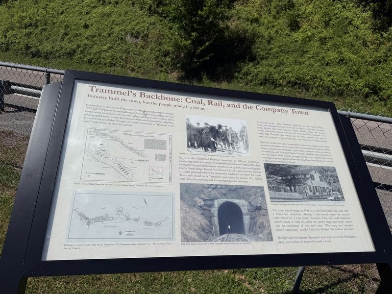
Trammel's Backbone: Coal, Rail, and the Company Town
Photographed by Devry Becker Jones (CC0), July 3, 2026
1. Trammel's Backbone: Coal, Rail, and the Company Town Marker
Hidden deep in the hills of Dickenson County, Trammel emerged between 1917 and 1919 to meet a national hunger for coal. The Virginia Banner Coal Corporation caved out this narrow, valley, building homes, offices, and a mining coperation to extract bituminous coal buried beneath the ridgelines. However, the spark that brought the small community of Trammel to life wasn't coal alone—it was the railroad.
In 1915, the Clinchfield Rialroad completed its Elkhorn Extension, connecting eastern Kentucky to coalfields in Southwest Virginia. This feat of engineering included massive tunnels and deep rock cuts, including the nearby Sandy Ridge Tunnel. On February 9, 1915, rail executive George L. Carter personally drove the ceremonial final spike just down the tracks. These rails would carry Trammel's coal across the eastern U.S., fueling steel mills, locomotives, and a booming industrial economy.
At its peak in the 1920s, Tammel employed over 300 miners. Black, white, and immigrant laborers lived side by side in a tight-knit company town divided into four sections: Upper, Middle, Main, and Lower Camp. The town's layout followed
this page online
Life here was hard but full of community. Homes were simple wood-frame structures with three to four rooms, coal stoves, and shared outhouses. Main Camp contained the essentials: a post office, company store, gas station, schoolhouse, and Trammel Baptist Church. Children played barefoot in the dirt streets while women swapped recipes over laundry lines. In the evenings, neighbors gathered for corn-shuckings, barn dances, or watch a film in the community theater.
The town school began in 1898 as a one-room cabin and grew into a four-room institution offering a nine-month term—an unusual achievement for a coal camp. Churches, clubs, and small businesses added texture to daily life, while the nearby tipple and trestle roared with the movement of coal and trains. "The camp was beautiful when I came here," recalled Lillie Mae Philips. "All painted and new."
Though built for business, Trammel's spirit was born in the friendships, labor, and routines of those who made
Topics. This historical marker is listed in these topic lists: Industry & Commerce • Natural Resources • Railroads & Streetcars • Settlements & Settlers. A significant historical date for this entry is February 9, 1915.
Location. 37° 0.666′ N, 82° 17.056′ W. Marker is in Trammel, Virginia, in Dickenson County. It is on Dante Mountain Road (Route 63) east of East Walnut Grove Road. Touch for map. Marker is at or near this postal address: 11742 Dante Mountain Rd, Dante VA 24237, United States of America. Touch for directions.

Regionally, this marker is in Southwest Virginia. It is also in the American South, specifically in the Upper South, in Appalachia, and specifically in Southern Appalachia. Globally, it is in North America, the Western Hemisphere, the Western World, and the Anglosphere. Historically, it finds itself in what was once the original Cherokee Nation, the territory of the Mississippian Culture, one of the original Thirteen Colonies, one of the Confederate States of America, and the Antebellum South.
Other nearby markers. At least 8 other markers are within 11 miles of this marker, measured as the crow flies: From Company Town to Community: Reclaiming Trammel (here, next to this marker); Dickenson County / Russell County (approx. 2.2 miles away); Old Buffalo School (approx. 6 miles away); Veterans Memorial (approx. 7½ miles away); McClure, VA. (approx. 8.3 miles away); Fort Gibson United Methodist Church (approx. 8.4 miles away); Russell’s Fort (approx. 9.3 miles away); Moore’s Fort (approx. 10.6 miles away).
Credits. This page was last revised on July 8, 2026. It was originally submitted on July 8, 2026, by Devry Becker Jones of Washington, District of Columbia. This page has been viewed 14 times since then. Photos: 1, 2. submitted on July 8, 2026, by Devry Becker Jones of Washington, District of Columbia.
