
Lawford in Essex, England, United Kingdom — Northwestern Europe (the British Isles)
Manningtree, Mistley, and Lawford
You're in the right place.
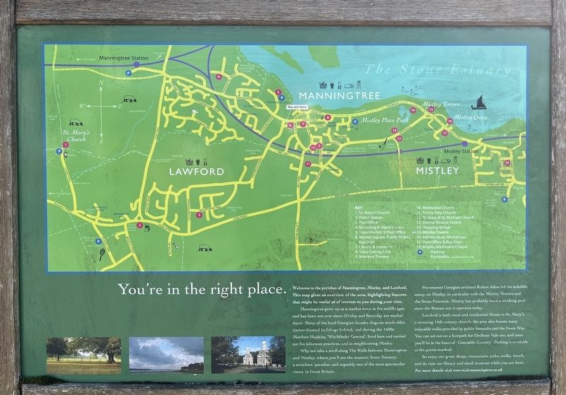
Photographed by Ray Gurganus, April 21, 2026
1. Manningtree, Mistley, and Lawford Marker
Manningtree grew up as a market town in the middle ages and has been one ever since (Friday and Saturday are market days). Many of the local Georgian facades disguise much older timber-framed buildings behind and during the 1600 Mathew Hopkins, 'Witchfinder General', lived here and carried out his infamous practices, and in neighbouring Mistley.
Why make a stroll along The Walls between Manningtree and Mistley where you'll see the majestic Stour Estuary; a twitchers' paradise, and arguably one of the most spectacular views in Great Britain.
Pre-eminent Georgian architect Robert Adam left his indelible stamp on Mistley, in particular with the Mistley Towers and the Swan Fountain. Mistley has probably been working port since the Roman era; it operates today.
Lawford is both rural and residential. Homes to St. Mary's, a stunning 14th century church, the area also boats many enjoyable walls provided by public footpaths and the Essex Way.
this page online
So enjoy our great shops, restaurants, pubs, walks back and do visit our library and all small museum while you are here.
Topics. This historical marker is listed in this topic list: Notable Buildings.
Location. 51° 56.72′ N, 1° 3.668′ E. Marker is in Lawford, England, in Essex. It is at the intersection of Station Road and Colchester Road, on the left when traveling west on Station Road. Touch for map. Marker is in this post office area: Lawford, England CO11 1XE, United Kingdom. Touch for directions.

Regionally, this marker is in the Greater South East. Globally, it is on the Atlantic Ocean, in the North Atlantic Region, in Europe, in Atlantic Europe, on one of the British Isles, in the Western World, and in the Anglosphere. Historically, it finds itself in what was once the Roman Empire.
Other nearby markers. At least 8 other markers are within 13 kilometers of this marker, measured as the crow flies: Mistley Towers (approx. 1.1 kilometers away); Walk in Constables Footsteps (approx. 1.2 kilometers away); a different marker also named Manningtree (approx. 1.2 kilometers away); Mistley Cobble Wall (approx. 1.3 kilometers away); Priory Street Bastion 5 (approx. 12.5 kilometers away); St Botolph's Priory (approx. 12.5 kilometers away); a different marker also named St Botolph's Priory (approx. 12.6 kilometers away); St Botolph's Churchyard (approx. 12.6 kilometers away). Touch for a list and map of all markers in Lawford.
Credits. This page was last revised on July 10, 2026. It was originally submitted on July 10, 2026, by Ray Gurganus of Washington, District of Columbia. This page has been viewed 6 times since then. Photo 1. submitted on July 10, 2026, by Ray Gurganus of Washington, District of Columbia. • Andrew Ruppenstein was the editor who published this page.
