
Downtown Roanoke , Virginia — The American South (Mid-Atlantic)
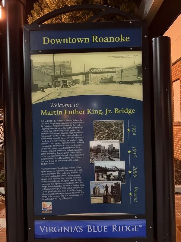
Welcome to Martin Luther King, Jr. Bridge
Downtown Roanoke
| — | Virginia's Blue Ridge | — |
Photographed by Devry Becker Jones (CC0), July 4, 2026
1. Welcome to Martin Luther King, Jr. Bridge Marker
Built in 1892 by the Norfolk & Western Railway, the First Street Bridge connects downtown Roanoke with the Gainsboro Neighborhood north of the tracks. Originally chartered as the Town of Gainesborough in 1835, the community developed as the predominantly AFrican American neighborhood of Gainsboro by the 1920s. The bridge, also known as the Henry Street Bridge, served as a physical divide in a racially-segregated society. Faced with the constraints of Jim Crow laws, the Black community developed its own businesses, institutions, services, and leaders with Henry Street serving as its commercial and entertainment cneter. Following desegregation in the 1960s, urban renewal destroyed much of the Gainsboro neighborhood. Both Henry Street and Gainsboro are now listed on the National Register of Historic Places.
The Warren Pony Truss Bridge consists of five spans resting on two bends, two stone piers and stone abutments. The bridge was repaired in 1953 and modified in 1990 to accommodate double-deck rail cars. After closing the steep and narrow vehicular bridge in 2000, the City renovated it as a pedestrian bridge in 2007.
this page online
Topics. This historical marker is listed in these topic lists: African Americans • Bridges & Viaducts • Settlements & Settlers. A significant historical year for this entry is 1892.
Location. 37° 16.355′ N, 79° 56.54′ W. Marker is in Roanoke, Virginia. It is in Downtown Roanoke. It is at the intersection of Salem Avenue Southwest and 1st Street Southwest, on the right when traveling west on Salem Avenue Southwest. Touch for map. Marker is at or near this postal address: 35 Campbell Ave SW, Roanoke VA 24011, United States of America. Touch for directions.

Regionally, this marker is in the Mountain Region and in Southwest Virginia. It is also in the American South and specifically in the Upper South. Globally, it is in North America, the Western Hemisphere, the Western World, and the Anglosphere. Historically, it finds itself in what
![Welcome to Martin Luther King, Jr. Bridge Marker [Reverse] image. Click for full size.](Photos9/957/Photo957042.jpg?710202654100PM "Welcome to Martin Luther King, Jr. Bridge Marker [Reverse]. Click for full size.")
Photographed by Devry Becker Jones (CC0), July 4, 2026
2. Welcome to Martin Luther King, Jr. Bridge Marker [Reverse]
Other nearby markers. At least 8 other markers are within walking distance of this marker: Dr. Martin Luther King Jr. Memorial Bridge (within shouting distance of this marker); N.W. Pugh & Co. (within shouting distance of this marker); Giles Brothers Furniture Co. (about 300 feet away, measured in a direct line); Rankin Jewelers (about 400 feet away); Roanoke Times (about 400 feet away); Oakey's (about 500 feet away); First National Bank (about 500 feet away); Norfolk & Western General Office Building (about 500 feet away). Touch for a list and map of all markers in Roanoke.
Another marker is no longer nearby. First Train to Big Lick (was about 400 feet away but has been confirmed missing).

Photographed by Devry Becker Jones (CC0), July 4, 2026
3. Welcome to Martin Luther King, Jr. Bridge Marker to the west of the bridge
Credits. This page was last revised on July 10, 2026. It was originally submitted on July 10, 2026, by Devry Becker Jones of Washington, District of Columbia. This page has been viewed 8 times since then. Photos: 1, 2, 3. submitted on July 10, 2026, by Devry Becker Jones of Washington, District of Columbia.
Editor’s want-list for this marker. Clear daylight photos of the marker and its context • Can you help?
