Naval Station Norfolk , Virginia — The American South (Mid-Atlantic)
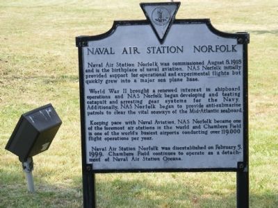
Naval Air Station Norfolk
Photographed by Don Morfe, June 4, 2008
1. Naval Air Station Norfolk Marker
World War II brought a renewed interest in shipboard operations and NAS Norfolk began developing and testing catapult and arresting gear systems for the Navy. Additionally, NAS Norfolk began to provide anti-submarine patrols to clear the vital seaways of the Mid-Atlantic seaboard.
Keeping pace with Naval Aviation, NAS Norfolk became one of the foremost air stations in the world and Chambers Field is one of the world’s busiest airports conducting over 119,000 flight operations per year.
Naval Air Station Norfolk was disestablished on February 5, 1999. Chambers Field continues to operate as a detachment of Naval Air Station Oceana.
Topics. This memorial is listed in these topic lists: Air & Space • War, World II. A significant historical date for this entry is August 8, 1918.
Location. 36° 56.707′ N, 76° 16.424′ W. Memorial is in Norfolk, Virginia. It is in Naval Station Norfolk. It is on Bellinger Boulevard
this page online

Regionally, this memorial is in Virginia’s Hampton Roads, specifically in Coastal Virginia, and in the Hampton Roads Metropolitan Area. It is also in the American South, specifically in the Upper South, in the Tidewater, and on the Eastern Seaboard. Globally, it is in the North Atlantic Region, North America, the Western Hemisphere, the Western World, and the Anglosphere. Historically, it finds itself in what was once the territory of the Mississippian Culture, one of the original Thirteen Colonies, one of the Confederate States of America, and the Antebellum South.
Other nearby markers. At least 8 other markers are within walking distance of this marker: Bell HH-1K (UH-1) Huey (a few steps from this marker); Grumman A-6E Intruder (within shouting distance of this marker); Grumman E-2C Hawkeye (within shouting
Photographed by Don Morfe, June 4, 2008
2. Naval Air Station Norfolk Marker
Photographed by Don Morfe, June 4, 2008
3. Naval Air Station Norfolk Marker

2024
4. Ely Memorial Park Station History Kiosk
A lengthy, multi-panel display about Naval Air Station Norfolk and the Aviation Depot is part of the park, just south by the F-14 Tomcat (Coordinates 36.94475720913638, -76.27363015567556)

2024
5. E-2 Hawkeye
Displayed at Ely Memorial Park. Marker is actually partially visible here, obscured by the first tree to the left of the aircraft - but part of its support frame is visible peeking out left of the trunk.
Credits. This page was last revised on July 12, 2026. It was originally submitted on December 23, 2013, by Don Morfe of Baltimore, Maryland. This page has been viewed 1,512 times since then and 83 times this year. Last updated on July 11, 2026, by Evan Dwyer of Richmond, Virginia. Photos: 1, 2, 3. submitted on December 23, 2013, by Don Morfe of Baltimore, Maryland. 4, 5. submitted on July 11, 2026. • Bernard Fisher was the editor who published this page.
