Littlefield in Mohave County, Arizona — The American Mountains (Southwest)
Tri-State Monument
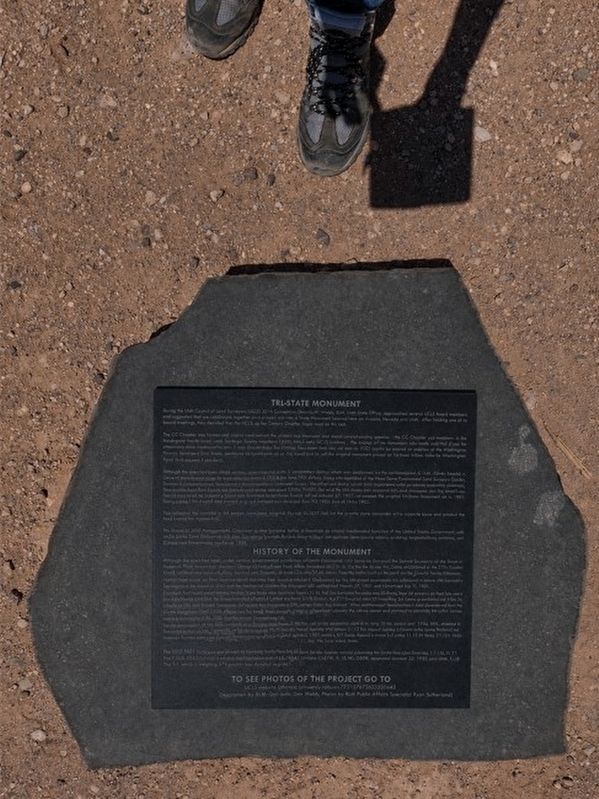
Photographed by Melissa H Spease
1. Tri-State Monument Marker
During the Utah Council of Land Surveyors (UCLS) 2016 Convention: Daniel W. Webb - BLM, Utah State Office, approached several UCLS Board members and suggested that we collaborate together and re-monument the Tri-State monument located here at Arizona, Nevada and Utah. After holding one of its board meetings it was decided that the UCLS, Color Country Chapter would take on this task.
The Color Country Chapter meet several times where the project was discussed and plans started coming together. The CC Chapter got members of the three State Professional Land Surveyor Society members (APLS, NALS, and UCLS) involved. The design of the monument was made and the plans for removal and placement were set. It was also decided the original monument that was set here in 1901 would be placed on display at the Washington County Administration Offices, located in St. George Utah. If you would like to see this original monument please go to these offices located at the corner of Tabernacle Street and 200 East Street in St. George.
The first step in this re-monumentation process was to perform a retracement survey, which was performed
this page online
After allowing the concrete to set another crew came out on February 3, 2017 and set the granite stone monument on its concrete base and stacked the rocks around the monument.
The Bureau of Land Management's Cadastral Survey Program is one of the oldest and most fundamental functions of the United States Government, with origins in the Land Ordinance of 1785. Cadastral Surveys are the foundation of our national land tenure system; creating, reestablishing, marking, and defining land boundaries.
History of the Monument
Under General

Photographed by Melissa H Spease, August 1, 2024
2. Tri-State Monument and Marker
Under General Land Office Contract dated October 13th, 1900, Howard B. Carpenter, U.S. Surveyor and Astronomer, was directed to survey the boundary line between the State of Utah and the Territory of Arizona. The survey was commenced March 24, 1901 and completed July 1, 1901.
Learning from local people living on the Virgin River near where it is crossed by the line between Nevada and a=Arizona, that old corners on that line were still in existence and that the sandstone shaft erected by Mr. James in 1870 to mark the 37th parallel was still standing, Mr. James proceeded out from St. George, Utah and Beaver Dam wash, in Arizona and found the 1870 James State line corners. After astronomical observations it was determined that the “James Monument was 111.51 chains too far north. Therefore pursuant to instructions I destroy the James corner and proceed to establish the initial corner at the intersection of the 37th parallel with the James line.”
“At the intersection of the 37th parallel north latitude with the James line I set a red sandstone shaft 6ft. Long 16 ins. Broad and 12 ins. Thick, dressed 8ins. Down from the top, diagonally in the ground, for the initial Monument, marked with letters 1 ½ ins. Square deeply graven in the stone NEVADA on the N.W. UTAH on the N.E. Arizona on the S.E. and Intl. Mont. 37 N.L. 1901 on the S.W. Faces. Raised a mound of stone 5 ½ ft. base 2 ½ ft. high around the shaft and dug pits 36x36x18 ins. N.E. And S. of corner 6 ft dist. No trees within limits.”
In addition to the 1870 and 1901 State boundary line surveys, Public Land Survey System surveys adjoining the State lines are: Nevada, T. 11 S., R. 71E., MDM, approved December 2, 1881, (suspended August 18, 1964); Arizona T. 42 N., W., R. 16 W., GSRM, approved January 25, 1922; and Utah, T. 43 s., R. 20 W., SLM, approved April 2, 1938.
Topics. This historical marker and monument is listed in this topic list: Notable Places. A significant historical date for this entry is August 16, 1870.
Location. 37° 0.012′ N, 114° 3.005′ W. Marker is in Littlefield, Arizona, in Mohave County. It is on no nearby street. There is no actual address for the marker. It is accessible by four-wheel drive vehicles with some clearance. Touch for map. Marker is in this post office area: Littlefield AZ 86432, United States of America. Touch for directions.

Regionally, this marker and monument is in the American Southwest and on the Colorado Plateau. Globally, it is in North America, the Western Hemisphere, the Western World, and the Anglosphere. Historically, it finds itself in what was once New Spain and also Mexico’s Alta California.
Other nearby markers. At least 8 other markers are within 14 miles of this marker, measured as the crow flies: Trading on the Early Frontier 1829-1848 (approx. 8.8 miles away in Utah); The Old Spanish Trail (approx. 9½ miles away); John David Pulsipher Home (approx. 13½ miles away in Nevada); Abram Woodbury Home and Gas Station (approx. 13½ miles away in Nevada); Charles Arthur Hughes Home (approx. 13½ miles away in Nevada); School and Gymnasium Block (approx. 13½ miles away in Nevada); Charles Hardy Home (approx. 13½ miles away in Nevada); Rock House (approx. 13½ miles away in Nevada). Touch for a list and map of all markers in Littlefield.
Credits. This page was last revised on July 21, 2026. It was originally submitted on July 17, 2026, by Melissa H Spease of Las Vegas, Nevada. This page has been viewed 39 times since then. Photos: 1, 2. submitted on July 17, 2026, by Melissa H Spease of Las Vegas, Nevada. • J. Makali Bruton was the editor who published this page.
