Sprague in Lincoln County, Washington — The American West (Northwest)
Railroads of the West
Photographed by Clayton Pickett, July 21, 2026
1. Railroads of the West Marker
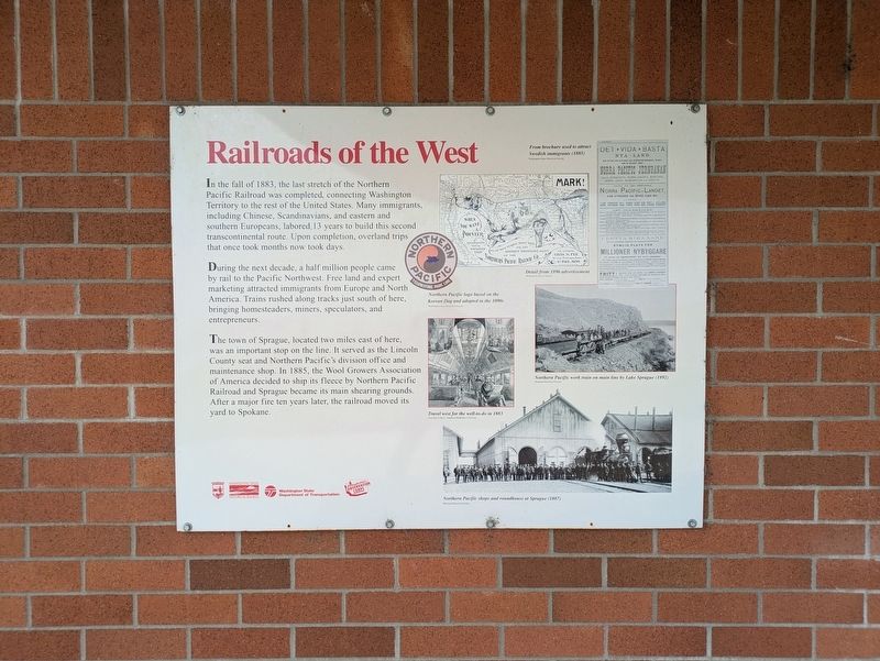
In the fall of 1883, the last stretch of the Northern Pacific Railroad was completed, connecting Washington Territory to the rest of the United States. Many immigrants, including Chinese, Scandinavians, and eastern and southern Europeans, labored 13 years to build this second transcontinental route. Upon completion, overland trips that once took months now took days.
During the next decade, a half million people came by rail to the Pacific Northwest. Free land and expert marketing attracted immigrants from Europe and North America. Trains rushed along tracks just south of here, bringing homesteaders, miners, speculators, and entrepreneurs.
The town of Sprague, located two miles east of here, was an important stop on the line. It served as the Lincoln County seat and Northern Pacific's division office and maintenance shop. In 1885, the Wool Growers Association of America decided to ship its fleece by Northern Pacific Railroad and Sprague became its main shearing grounds. After a major fire ten years later, the railroad moved its yard to Spokane.
(Photo Captions)
From brochure use to attract Swedish immigrants (1885)
Washington State Historical Society
Detail from 1896 advertisement
Montana Historical Society
Northern Pacific logo based on the Korean flag and adopted in the 1890s
Washington State Historical Society
Northern Pacific work train on main line by Lake Sprague (1892)
Montana Historical Society
Travel west for the well-to-do in 1883
DeGolyer Library, Southern Methodist University
Northern Pacific shops and roundhouse at Sprague (1887)
Montana Historical Society
Erected by Washington
this page online
Topics. This historical marker is listed in these topic lists: Industry & Commerce • Railroads & Streetcars • Settlements & Settlers. A significant historical year for this entry is 1883.
Location. 47° 17.359′ N, 118° 2.054′ W. Marker is in Sprague, Washington, in Lincoln County. It can be reached from Interstate 90 11 miles east of Danekas Road, on the right when traveling east. Touch for map. Marker is at or near this postal address: 43794 I-90, Sprague WA 99032, United States of America. Touch for directions.

Regionally, this marker is in the Columbia Basin and in Greater Spokane. It is also in the American Mountain West and in the Lewis & Clark Corridor. Globally, it is in North America, the Pacific Rim, the Western Hemisphere, the Western World, and the Anglosphere.
Other nearby markers. At least one other marker is within 3 miles of this marker, measured as the crow flies: Mary Queen of Heaven Parish (approx. 2.9 miles away).

Photographed by Clayton Pickett, July 21, 2026
2. Railroads of the West Marker
Credits. This page was last revised on July 23, 2026. It was originally submitted on July 22, 2026, by Clayton Pickett of Richland, Washington. This page has been viewed 12 times since then. Photos: 1, 2. submitted on July 22, 2026, by Clayton Pickett of Richland, Washington. • James Hulse was the editor who published this page.
