Honey Grove in Fannin County, Texas — The American South (West South Central)
Main Street Presbyterian Church
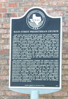
Photographed by Duane and Tracy Marsteller, May 2, 2026
1. Main Street Presbyterian Church Marker
Five historic congregations comprise the current Main Street Presbyterian Church. After uniting with First Presbyterian Church in Honey Grove (organized 1861) in 1911, Main Street Presbyterian Church also incorporated
this page online
Erected 2013 by Texas Historical Commission. (Marker Number 17516.)
Topics. This historical marker is listed in this topic list: Religion & Religious Structures. A significant historical month for this entry is February 1858.
Location. 33° 34.966′ N, 95° 54.437′ W. Marker is in Honey Grove, Texas, in Fannin County. It is at the intersection of East Main Street (Texas Route 56) and 9th Street, on the right when traveling east on East Main Street. Touch for map. Marker is at or near this postal address: 504 E Main St, Honey Grove TX 75446, United States of America.

Photographed by Duane and Tracy Marsteller, May 2, 2026
2. Main Street Presbyterian Church Marker

Regionally, this marker is in the Prairies & Lakes Region. It is also in the American South. Globally, it is in North America, a Gulf of Mexico state, the Western Hemisphere, the Western World, and the Anglosphere. Historically, it finds itself in what was once New Spain, the Republic of Texas, one of the Confederate States of America, and the Antebellum South.
Other nearby markers. At least 8 other markers are within walking distance of this marker: Church of St. Mark, the Evangelist, Episcopal (about 300 feet away, measured in a direct line); First Baptist Church of Honey Grove (about 300 feet away); Honey Grove Lodge No. 164, A.F. & A.M. (about 600 feet away); Honey Grove City Hall (about 800 feet away); McKenzie Methodist Church (approx. 0.2 miles away); Site of Bralley-Pendleton School (approx. ¼ mile away); Dial Home (approx. ¼ mile away); James Thomas Holt (approx. half a mile away). Touch for a list and map of all markers in Honey Grove.
Also see . . . Main Street Presbyterian Church, Honey Grove. The Main Street Presbyterian Church was tragically destroyed by fire on the early

via Honey Grove Preservation League (Public Domain)
3. Historic Main Street Presbyterian Church
Fire from a lightning strike destroyed the church in February 2013, just weeks after the historical marker was approved.
Credits. This page was last revised on July 22, 2026. It was originally submitted on July 22, 2026, by Duane and Tracy Marsteller of Murfreesboro, Tennessee. This page has been viewed 11 times since then. Photos: 1, 2, 3. submitted on July 22, 2026, by Duane and Tracy Marsteller of Murfreesboro, Tennessee.
